Dinah McIntire and Her Hill

Jim Gerhart, August 2019

Dinah McIntire died 200 years ago in Lancaster, in May 1819, at the reported age of 113. She was well known around Lancaster in the early years of the nineteenth century as the fortuneteller who worked at the White Swan Tavern in the square. Her death warranted a rare obituary in the Lancaster Journal, something usually reserved only for prominent male citizens, as well as a note in Reverend Joseph Clarkson’s journal about her burial in the St. James Episcopal Church cemetery, despite the fact that he was in Philadelphia at the time.

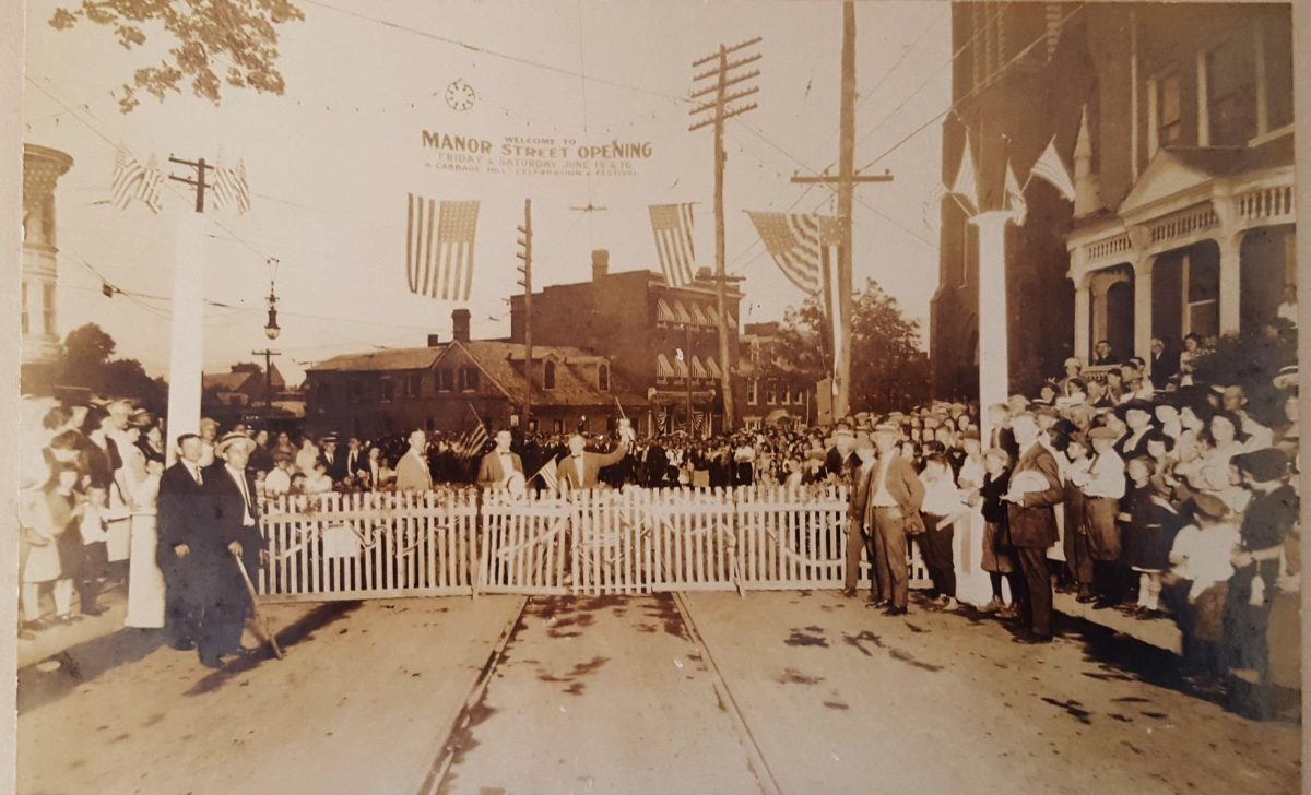
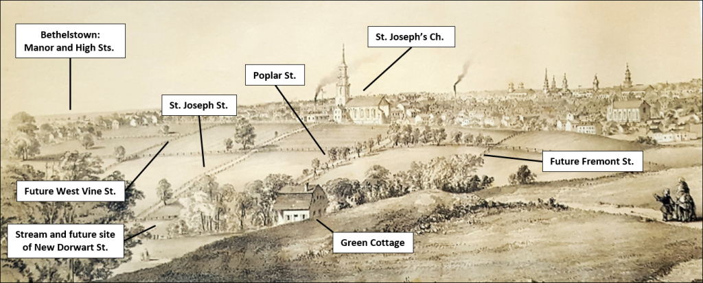
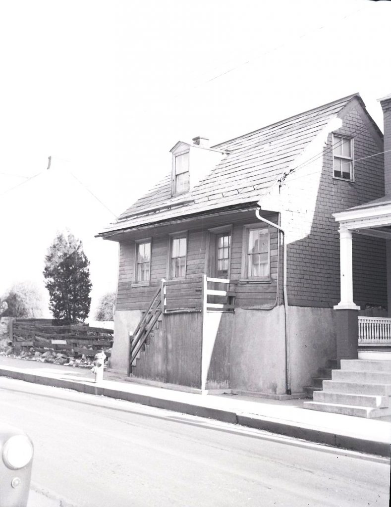
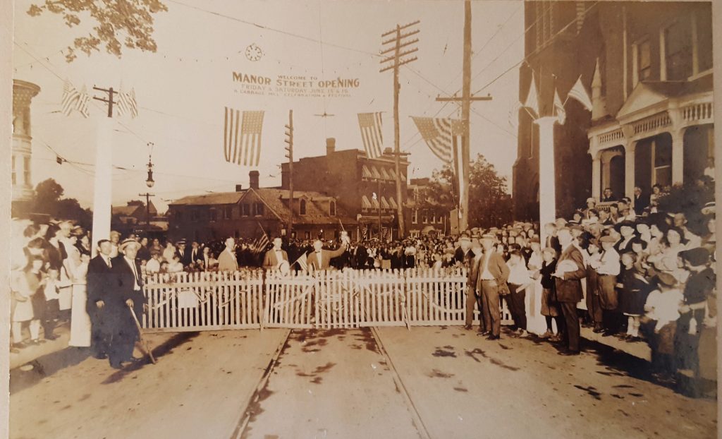
Dinah was one of the few women of her time who owned property; she had a small house near the intersection of West Strawberry and West Vine Streets. The site of her house was said to be near the highest point in that part of Lancaster, at the angle between West Strawberry and West Vine, and her notoriety was such that the hill on which she lived became known as Dinah’s Hill (see photo). By all accounts, she lived a remarkable life—all the more remarkable because she was African American and a slave for most of her life, including here in Lancaster.

Photograph of the intersection of West Strawberry and West Vine Streets,
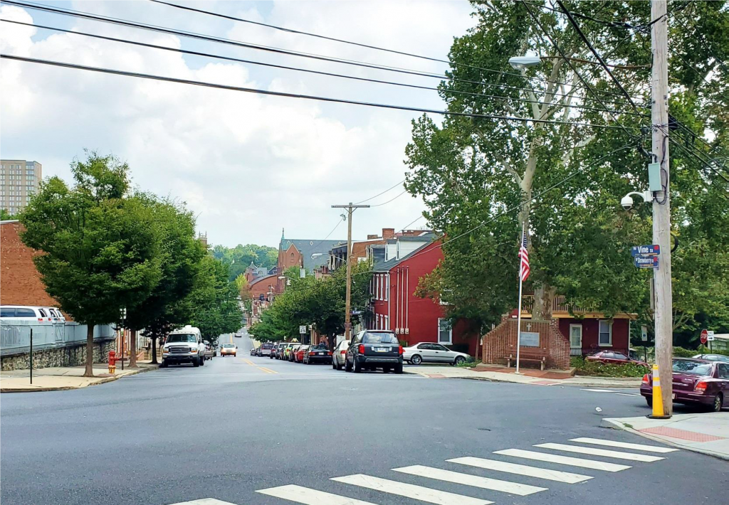
looking east down the hill on West Vine. Dinah McIntire lived in a small
frame house at this intersection, which is near the highest point in this part
of Cabbage Hill, which was called “Dinah’s Hill” throughout most of the 1800s.

According to several sources, Dinah McIntire was born into slavery in the town of Princess Anne, Somerset County, Maryland, about 1706. She spent the first half of her long life in Maryland, and raised four children there. She was already in her fifties when Matthias Slough, a prominent early citizen of Lancaster, bought her and brought her north to work at his White Swan Tavern.

When Dinah died in 1819, she owned two, and possibly three, lots of land on the northeast edge of Cabbage Hill. She owned two of the lots as early as 1798, when the lots were taxed as part of the 1798 federal Direct Tax. The tax was based on the amount of land owned and the number of windows and the total number of panes in the windows. One of Dinah’s lots was 62 x 242 feet and contained an 18 x 22 foot house and a 15 x 20 foot stable. The house was a one-story log and brick house with two windows of six panes each, and the stable was made of logs. The other lot she owned in 1798 was larger and apparently not built on; it measured 137 x 191 feet, adjoining the first lot.

In 1816, three years before her death, Dinah McIntire, having long outlived her four children, prepared a will in which she left all of her property and belongings to Jacob Getz, a young Lancaster silversmith. Like Dinah, Getz attended St. James Church in 1815, when he and his wife Martha had their first child baptized there. By 1816, when Dinah wrote her will, Getz had apparently befriended her to such an extent that she named him as her executor and sole heir.

Map showing the two lots that Dinah McIntire owned from at least 1798 to 1819 when she died. The lots are near the intersection of West Strawberry and West Vine, where Dinah is supposed to have lived. (The map is from 1875, so the features shown are not the same as they were when Dinah was living there. The map is modified from Everts & Stewart, Lancaster County Atlas, 1875.)

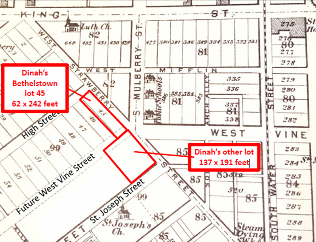
When Dinah died in 1819, Getz became the owner of Dinah’s property. Ground-rent records for Bethelstown, laid out by Samuel Bethel, Jr., in 1762, show that Jacob Getz became the owner of Bethelstown lot 45 after Dinah’s death. Lot 45 was 62 feet wide and 242 feet deep, and was bounded on its long dimension by West Strawberry between High and West Vine. This was clearly one of the two lots left to Getz by Dinah McIntire, and an examination of deeds shows that the other lot, which was a little larger, was immediately adjacent to the southeast across what is now the extension of West Vine southwest of West Strawberry (see map).

However, there is still some uncertainty surrounding exactly where Dinah McIntire actually lived. One obvious possibility is the 18 x 22 log and brick house on Bethelstown lot 45. But the most likely place for a house to have been built on that lot was on the High Street end of the lot. At the time Bethelstown was laid out, the other end of the lot did not front a street (the extension of West Vine Street didn’t occur until much later). And if Dinah had lived on the High Street end of lot 45, she would not have been at the angle of West Strawberry and West Vine, and she would not have had a direct view down the hill on West Vine, as numerous writers have claimed for her.

An article in The News Journal of Lancaster on June 9, 1898, provides an alternative, and I think more likely, location where Dinah may have lived. The article discusses how “another old landmark of the city” was about to be removed. The landmark had been condemned  because it was too close to the street and had become an eyesore. That landmark was a small frame cabin on the corner of West Vine and West Strawberry, and the article states that it was reputed to have been the house where Dinah had lived almost a century before.

An examination of an old fire-insurance map of the city from 1897 shows that a small one-and-a-half-story frame house, then being used as a tin shop, did indeed stick out into the street at the angle where West Strawberry and West Vine meet. A 1912 fire-insurance map shows that the small frame house was no longer there, which is consistent with the claim of the newspaper article that the house was about to be removed in 1898 (see side-by-side maps). I believe it is likely that this small house is where Dinah McIntire lived, and that this small piece of land was the third lot that some writers have attributed to her. The exact site of Dinah’s little house was where the flagpole is today in front of the memorial to fallen soldiers.

Dinah McIntire probably lived in the small house shown in the 1897 map as a tin shop (green)
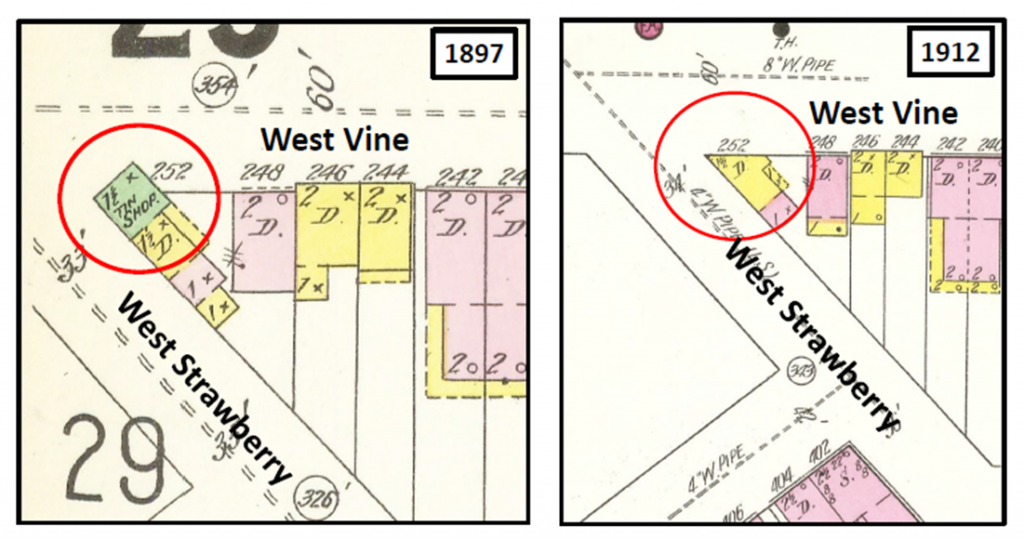
jutting out into the street. An 1898 newspaper article stated that Dinah’s old house was about
to be removed. The 1912 map shows that Dinah’s old house was removed as planned. Maps
modified from Sanborn Insurance Maps of 1897 and 1912.

Now, to complete the story of Dinah McIntire, we are compelled to circle back to the potentially problematic life of Matthias Slough, Dinah’s Lancaster slave master. Slough was as prominent a citizen as there was in Lancaster in the late 1700s. During the Revolutionary War, he served as the Colonel of the Seventh Battalion of the Pennsylvania Militia, and saw action at the Battle of Long Island. He also served at various times as assistant burgess, county coroner, county treasurer, and member of the Pennsylvania Provincial Assembly and General Assembly, all while he was running the very popular White Swan Tavern.

Certainly, this is a fine list of accomplishments worthy of our respect. However, just like numerous other prominent Lancaster citizens in the eighteenth century, Slough’s legacy is compromised by the fact that he was a slave owner. From 1770 to 1800, Slough owned at least three to four slaves at a time. In fact, a registry of Lancaster slaves indicates he owned eleven slaves in 1780.

Curiously, Dinah McIntire is not one of the eleven listed slaves in 1780. Did Slough free her before 1780? We know she was freed at least by 1798, because she owned property then. It is possible she was freed before 1780, because it was common for slave owners to free slaves when they reached old age and Dinah was already in her seventies in 1780. Whether he freed Dinah before 1780 or closer to 1798, it is reasonable to think that the wealthy Slough may have rewarded her for her years of servitude, and that her ownership of land may have been a result of that reward.

Whether we should temper our respect for Matthias Slough because he was so thoroughly invested in the “peculiar institution” of slavery is a question for individual conscience and professional historians. It seems fitting, though, that Dinah McIntire outlived her former slave master Slough, and that her newspaper obituary was almost as long as his obituary. On top of that, Dinah was the only one of the two for whom a hill was named.

The Largest Celebration in the History of Cabbage Hill

Jim Gerhart

August 1, 2019

The greatest expression of civic pride ever to take place on Cabbage Hill in the Eighth Ward of Lancaster occurred on June 15-16, 1923. On the evenings of those two days, a huge festival drew close to 10,000 people to Manor Street to celebrate the long-awaited completion of the paving of the street. More than $6,000 (about $84,000 in today’s dollars) was raised to benefit Rodney Park, a new city park on a triangle of land between Third, Rodney, and Crystal Streets.

The surface of Manor Street had been in terrible condition for many years. Finally, in early August 1922, work crews began the process of excavating the street so it could be paved with concrete. The city’s contractor, Swanger-Fackler Construction Company of Lebanon, was responsible for the overall project and the paving of most of the street, and Conestoga Traction Company was responsible for moving the trolley tracks from the edge of the street to the middle, and paving the street around the trolley tracks. The work proceeded slowly, as the crews ran into several unexpected complications as they excavated 150 years’ worth of old street surfaces.

When cold weather set in during the late fall and concrete could no longer be poured, work was halted for the winter, leaving some sections of the street torn up and virtually impassable. Fortunately, by the first week of April in the spring of 1923, the weather was good enough for the crews to get back to work. Progress was steady throughout April and May, and by late May the residents of the Eighth Ward were hopeful that the work would finally be completed by mid-June.

The Eighth Ward Community Association met on May 25, May 31, and June 7 to develop plans for a festival to celebrate the opening of the newly paved Manor Street. The festival was scheduled for June 15-16, 1923, and the Association decided to dedicate the proceeds of the festival to outfitting Rodney Park—acquired by the city just two months earlier—with playground equipment and a surrounding sidewalk for roller-skating.

Advertisement for festival in Examiner & New Era, June 15, 1923

In late May, the Association canvassed door to door in the Eighth Ward to gauge the level of interest and ask for donations to support the festival. The canvassing generated much enthusiasm and many donations; in fact, the level of interest was so high that the Association decided to expand the scope of the event from just a Manor Street opening  to “A Cabbage Hill Celebration and Festival”. One of the leaders of the Association said that “this is the first time in the history of the city that such a celebration has been held” and that “it is for all the people”.

To plan the festival, twenty-six committees were established, with each committee having a chairman and three to five other men as members. The women had their own committees, most of which corresponded in topic with the men’s committees, and the two sets of committees worked together to prepare for the festival. Committee chairs were selected for their expertise in the area of the committee’s topic. For example, Christ Kunzler of Kunzler’s Meat Market was the chair of the Hot Frankfurter committee, and Leo Houck of boxing fame was the chair of the Sports committee.

The committees included: Program, Publicity, Music, Decorations, Amusement, Sports, Dancing, Candy, Prizes, Hot Frankfurters, Soft Drinks, Popcorn, Flowers, Ice Cream, Fruit, Truck, Ice, Printing, Cigars, Equipment, Lumber/Chairs/Tables, Public safety, Tags, Cakes, Novelties, and Fancy Work. Probably to many people’s chagrin, there was no Beer committee—at least not officially—because the 18th Amendment (Prohibition) had gone into effect a few years earlier.

Advertisement for festival in Intelligence Journal, June 15, 1923

In the days leading up to the festival, several items were donated to be used as prizes. Congressman William Griest donated a new Ruud water heater that was put on display in the window of Louis Fellman’s hardware store (568 Manor Street) to help ratchet up interest. The Conestoga Traction Company donated a new Clark Jewel gas range, which was also displayed at Fellman’s store. The Friends of the Eighth Ward Community Association donated a $550 mahogany bedroom suite that was displayed at Hoffmeier’s furniture store on East King Street near the square.

Cash donations also were made. Christ Kunzler took up a collection of $87 at an Elks Club dinner held the week before the festival, and he also paid for the first hour of music by a band at the festival. Hamilton Watch Factory and Armstrong Linoleum Company each gave $50, as did the Fraim-Slaymaker Lock Company. The Select Council also presented a cash donation. In addition, the Intelligencer Journal and the Examiner-New Era newspapers would supply Rodney Park with a drinking fountain and a flagpole.

To the relief of all the committees, the paving of Manor Street was completed on time, and by the afternoon of Friday, June 15, the final preparations for the festival were underway. Two large banners were strung across the street at the ends of Manor Street—one at the crest of the hill near West King Street and one near South West End Avenue. American flags and bunting were displayed along the street and on many of the houses (Flag Day was the previous day), and colored electric lights were strung along and across Manor Street from West King Street to Fairview Avenue. Dozens of booths that had been built by the residents and decorated with flowers lined the street on both sides.

It was partly cloudy and about 80 degrees when the festival kicked off at 6:30 p.m. Friday evening. At that time, the leaders of the Eighth Ward Community Association, the American Legion Band, and some 500 school children of the Eighth Ward departed in a parade from the intersection of Manor and Dorwart Streets. They marched to City Hall, where they met Mayor Frank Musser and other city officials and escorted them back in the parade to the intersection of Manor and West King Streets, where a fence barrier had been erected across Manor Street.

At the barrier, the mayor was presented with a new axe, and with one stroke he broke through the ceremonial barrier, officially opening the newly paved street.  Immediately after the barrier was broken, a chorus of children sang a welcoming song, and a switch was flipped, lighting all the colored electric lights along the street. The Star Spangled Banner was played, followed by a short speech by the mayor. At the end of the ceremony, the whole group of officials, school children, and the American Legion Band paraded the length of Manor Street to great cheering. The festival was officially underway.

Photo of the ceremonial breaking of a barrier to open the newly paver Manor Street on June 15, 1923. The barrier is in front of 412-414 Manor St. Mayor Frank Musser stands in front of the barrier to the left. The banner reads, “Welcome to the Manor Street Opening, Friday & Saturday, June 15 & 16, A Cabbage Hill Celebration and Festival”.

For the festival, Manor Street was divided into three segments, each with a distinct focus—dancing, boxing, and amusements. Four bands, including the American Legion Band, the Iroquois Band, and the City Band, participated over the two nights, and each one was stationed at a different segment. The segments were linked together by the strings of colored lights that extended along the entire stretch of the street, and by 33 booths that lined the streets between the segments, offering the Eighth Ward’s best food, drinks, clothing, novelties, and hand-made items for sale.

The block of Manor Street between Laurel Street and Fairview Avenue was set aside for street dancing, with the music supplied by the American Legion Band. Rousing Roaring Twenties music was no doubt on the program, and the young people of the Eighth Ward danced until the festival closed each night. At one point during the dancing, the lights briefly went out, and the newspaper slyly reported that this unexpected feature was much appreciated by the young revelers.

The intersection of Manor and Dorwart Streets was designated for exhibition boxing matches, and a ring was set up in the street. Each night, there were five, three-round exhibition matches arranged by Leo Houck, the Eighth Ward’s own boxing hero. One match was for the championship of the Fraim-Slaymaker Lock Company (Young Biddy vs. Willie Bloom) and another was for the 125-pound title of Manor Street (Battling Fuzzy vs. Kid Carney). The final, much anticipated match was Leo Houck, who had fought many of the world’s best boxers in the previous two decades, facing off against his long-time sparring partner, Jule Ritchie. Unfortunately, Ritchie was late and the feature bout had to be replaced with a quickly arranged one between two different boxers.

The intersection of Manor and Third Streets was set up for amusements. Eddie Fisher, a well-known local clown, was in charge of the program at this location. Each night, the YMCA provided a gymnastics and stunts exhibition, and Fisher and a troupe of clowns performed. A little farther down the hill, the Strand Theater in the 600 block of Manor Street provided a free showing of a silent movie, and Brinkman’s Metropolitan Four sang a selection of songs. On Saturday night the Strand hosted a public wedding of a couple from Columbia, officiated by a pastor from Marietta.

An unusual feature of the festival that must have served as a good ice breaker was the Miss Rodney Park contest. Each evening, in three different hour-long time slots, a secretly selected young woman was designated as Miss Rodney Park for that hour. She went out among the crowd incognito and the first person who approached her with “You are Miss Rodney Park”, would be the prize winner for that hour. No doubt many young women were approached by many young men, but Miss Rodney Park was only correctly identified three times.

By the time midnight rolled around on Saturday night and the festival was over, it was clear to everyone that it had been a much bigger success than anyone had imagined. The crowds had been huge (almost 10,000 over two nights), the booths were almost completely sold out of their merchandise, and every featured event on the program had been a big hit. Over the next couple of days, as cleanup took place, the Eighth Ward Community Association counted up the proceeds and decided on the distribution of prizes, which were then awarded on Tuesday night, June 19, at Fellman’s hardware store. The amount of money raised exceeded $6,000, and on the night of June 20, again at Fellman’s store, the Community Association met with the City Parks Committee to discuss how to best use the money for Rodney Park.

The Eighth Ward had done itself proud. For two nights, the residents had channeled their abundant civic pride into accomplishing the largest festival ever seen on Cabbage Hill. The people of other parts of Lancaster who had joined in the festivities left with “a lot of respect for the manner in which the Eighth Ward does things”, as one of the newspaper articles put it. It was hoped that the paving of the street and the successful festival might end the long held opinion that Cabbage Hill was not treated like a fully accepted part of the city. In fact, one of the newspaper articles stated that the reconstruction of the street was “the first thing worth while the Hill has ever gotten from a city administration”. At least for two nights, on June 15-16, 1923, Cabbage Hill had finally gotten its due.

The City of Lancaster and SoWe are committed to promoting the same kind of neighborhood pride that made the 1923 celebration such a success. The city has installed pedestrian-style streetlights along Manor Street and part of West King Street, and has started the process of planting trees along the street as well. And SoWe, with its many partners, is working on numerous initiatives to build neighborhood pride, including a cost-sharing program to improve building façades on Manor Street, especially those that once had storefronts. It is hoped that all these efforts will help rekindle some of the proud neighborhood spirit of the past.


An Old Lithograph Captures Cabbage Hill on the Cusp of Development

Jim Gerhart

Sometimes an image inadvertently captures a scene just before it changes forever, locking in all the little details that will never be the same again. A lithograph of Lancaster as seen from the southwest in 1852 is just such an image. It was drawn with such attention to detail that it is almost as good as a photograph. But in one way, it is even better than a photograph because a photographer in 1852 would not have had the specialized equipment to take an almost 180-degree panoramic photograph.

The lithograph is entitled “View of Lancaster, Pa.” It was drawn by Charles R. Parsons in 1852 and published by James T. Palmatary in January 1853. Parsons was an English immigrant who apprenticed under George Endicott in New York City, and “View of Lancaster, Pa.”, done when he was thirty-one, was one of the first works of his long and distinguished career. Palmatary, also an English immigrant, was a famous lithographer in the mid-nineteenth century, who published many innovative lithographs of birds-eye views of major American cities. Parsons and Palmatary executed their work well, as an article in the Lancaster Intelligencer of January 18, 1853, advertised their 18×34-inch product as being “drawn from nature” and having a “rich and life-like appearance”.

“View of Lancaster, Pa.”, drawn by Charles R. Parsons in 1852 and published by James T. Palmatary in 1853.

The “View” shown in the lithograph extends from Manor and High Streets (Bethelstown) on the left (northwest) to Woodward Hill Cemetery on the right (southeast). It shows Lancaster as it appeared in 1852 to an artist sitting on a hill with an unobstructed view of the city. It quite faithfully reproduces churches, schools, factories, public buildings, and other landmarks of 1852 Lancaster with exacting precision. It includes some landmarks that had only recently been added to the city’s skyline, such as Fulton Hall (1852), Woodward Hill Cemetery (1852), Conestoga Steam Cotton Mills (1847), St. Joseph’s Catholic Church (1849), and even the new County Courthouse (1852) shown under construction in the scene.

But even more noteworthy for the history of Cabbage Hill is what is captured in the foreground of the “View”—a nearly empty landscape that had no inkling it was about to experience a virtual frenzy of development leading to the densely built and populated neighborhood we see today. Open pastures separated by fences and tree-lined farm lanes dominate the foreground of the lithograph. There are only two buildings seen on the central part of what would soon be called Cabbage Hill—St. Joseph’s Church in the left rear foreground and a house in the left middle foreground.

The topography of the Hill, which is difficult to fully grasp today amid all the houses, is clearly depicted. One can see that Cabbage Hill is really two hills separated by a valley. The hill in the foreground where Charles Parsons stood to draw the “View” is the southern hill and the hill where St. Joseph’s Church stands is the northern hill. The valley traversing the scene from left to right is the valley in which a tributary of Hoffman’s Run flowed on its way to a larger stream along South Water Street.

Several features that are important to the history of Cabbage Hill are captured in the scene. On the far left, several rows of houses trail away from the city toward the edge of the drawing. This is the only part of today’s Cabbage Hill that was developed in 1852. It is the neighborhood of Bethelstown along the first two blocks of High and Manor Streets that was laid out by Samuel Bethel, Jr. in 1762, and that had just begun to finally take off in the late 1840s. In the right center of the drawing are the three large buildings of the Conestoga Steam Cotton Mills on South Prince Street. In the late 1840s, these three mills and St. Joseph’s Church played key roles in attracting the new residents that were about to lead to the explosive growth of Cabbage Hill.

New streets and future streets can be identified on the lithograph. St Joseph Street can be seen as not much more than a fence-lined  farm lane emanating from the left side of St. Joseph’s Church and heading down to the tributary stream in the valley, where some thirty years later, New Dorwart Street would be constructed after the stream was drained into a large sewer beneath the street. To the right of St. Joseph Street, another fence-lined and tree-lined lane—Poplar Street—follows the same slope down to the valley bottom (are the trees lining this lane by any chance poplar trees?). Less well defined to the left of St. Joseph Street is another parallel fence line that looks like it might be the future site of West Vine Street. A similar fence line to the right of Poplar Street could be the future Fremont Street, as it seems to be leading to the house in the left foreground, which stands on Fremont Street today.

Enlargement of the left side of “View of Lancaster, Pa.”, showing important features of Cabbage Hill in 1852.

That house, partially hidden from Parsons’ view by the southern hill, and nestled on the lower slope above the valley floor, was the summer cottage of Catherine “Kitty” Yeates, daughter of Jasper Yeates, prominent lawyer and judge of late eighteenth and early nineteenth century Lancaster. The house, known as Green Cottage, was built about 1820 as Miss Yeates’ summer cottage, and was the first house other than small farmhouses in the central part of Cabbage Hill. The artist even captured the slight change in angle of the gambrel roof that can only be seen in today’s roof upon close inspection. The house was later owned by Alexander J. Gerz and used as a hotel, and it still stands today at 613 Fremont Street, adapted for use as apartments.

The buildings in the “View” are drawn with such accuracy that one can use their positions relative to each other to locate the general area where Charles R. Parsons positioned himself to make the drawing. The spot where Parsons set up his easel was the hilltop near where Frank’s Garage is located in the 600 block of Union Street. Only from that location does the alignment of the Yeates cottage with St. Joseph’s Church match the alignment in the “View”. And only there do the relationships among the buildings of the Conestoga Steam Cotton Mills (now Water Street Rescue Mission , Carter & MacRae Elementary School, and the office of the School District of Lancaster), agree with the relationships in the lithograph

Fortunately, a high-quality original of this lithograph survives in the Wheatland Collection at LancasterHistory. It currently hangs in what appears to be its original frame in the rear stair hall at Wheatland. It provides a rare glimpse of a moment in time, fortuitously captured more than 165 years ago, just before the central part of Cabbage Hill blossomed with development.

When Did Cabbage Hill Get Its Name, and Under What Circumstances?

Jim Gerhart, May 2019

Tradition has it that Cabbage Hill was named because of the smell from the making of sauerkraut that permeated the air above the Eighth Ward, whose residents were mostly of German descent. But when did the name enter common usage? And was the name intended to be complimentary or derogatory?

The first written reference to Cabbage Hill that I can find (so far) was in the October 11, 1871 edition of the Lancaster Intelligencer, and the subject of the article may provide a clue as to the circumstances under which the name came about. The name, Cabbage Hill, appeared in an article entitled, “RADICAL MEETING IN THE EIGHTH WARD”, which was a lunch meeting that took place at Samuel Erisman’s saloon at the corner of West Strawberry and West Vine Streets on October 11, 1871. The sentence in the article that contains the reference to Cabbage Hill is, “The Radical politicians, scared almost out of their boots, by the outpouring of the Democracy of Cabbage Hill, on Tuesday evening, determined to get up a counter demonstration to undo the damage which had been done to the cause of Reed, plunder and usury.”

The “Radical politicians” who met in Erisman’s saloon were members of a wing of the Republican party that before and during the Civil War, had advocated strongly for the total defeat of the secessionists and the end of slavery, and after the Civil War, had urged harsh punishment for the Confederate states. The “Democracy of Cabbage Hill” was the German population of the Eighth Ward, who were part of a wing of the northern Democratic party that strongly opposed the need for the Civil War and called for a truce and peace with the Confederacy. The Republican party dubbed the northern Democratic wing “Copperheads”, a name meant to disparage them by comparing them to the treacherous poisonous snake. Interestingly, another name for the German Democrats of the Eighth Ward, in an article in Father Abraham from October 23, 1868, was “Sauer Kraut Gorillas”, clearly not a compliment.

The lunch meeting of the Radical Republicans in Erisman’s saloon was apparently an attempt to upstage a very well attended meeting the previous evening of the Democrats of the Eighth Ward. An election was approaching, and the office of Mayor of Lancaster was on the ballot. The Republican Mayor whose tenure was just about to end was William Atlee, and the next Republican candidate for Mayor was George Reed. Both Atlee and Reed were at the lunch meeting at the saloon, trying to drum up votes among the residents of the Eighth Ward. To encourage attendance, a sauerkraut meal and free beer were on the menu. Unfortunately for the Mayor and Mayor-hopeful, the meeting was poorly attended, and somebody forgot to make the sauerkraut, and after a few beers and a speech by the current Mayor that was “a weak defense of his administration”, it was clear that Eighth Ward voters were going to favor the Democratic candidate for Mayor (Frederick Pyfer) in the upcoming election. 

So it appears that the name of Cabbage Hill was in common usage by October 1871. Also, we can surmise that the Eighth Ward was probably not called Cabbage Hill before the mid-1850s because it was not until then that the central part of the Eighth Ward began to be populated. My guess is that the name, Cabbage Hill, came into usage sometime in the 1860s, but I have no further evidence to back that up.

As for the circumstances under which the name came into common usage, it is possible that it came about as a result of the political differences accentuated by the Civil War and its aftermath. When considered in the context of another name from the same era, Sauer Kraut Gorillas, the name, Cabbage Hill, seems likely to have been a derogatory label bestowed by the Radical Republicans of Lancaster on the members of their rival party in the German Eighth Ward.  I am going to keep my eyes open for additional information on this topic. In the meantime, if anyone knows of an earlier usage of the name, Cabbage Hill, or about the circumstances under which it originated, please get in touch with me at SoWeCommunicate@sowelancaster.org  I will update this story with any new information in the next entry for this blog. Let’s see if together we can answer these long-asked questions about the origin of “Cabbage Hill”.                  

History on the Hill

Cabbage Hill has a long history as one of Lancaster’s most vibrant and enterprising neighborhoods. Quaint houses, hilly streets, a diverse population, and many neighborhood businesses are some of its attractions. But as we walk or drive around the Hill, it is easy to miss the amazing amount of rich history right before our eyes. Just beneath the surface of what we see are a couple of centuries’ worth of fascinating stories about the people, buildings, and businesses that once existed here.

The William Paulsen family posed in front of their house and bakery at 560 Manor Street in the summer of 1902.  (From private collection of Suzanne Stalling)

I am a retired geologist who was born and raised in Lancaster, and I have always been interested in history. For the past fifteen years, I have been researching selected topics of Lancaster’s history, with a recent emphasis on Cabbage Hill. Much of my research has been focused on my Hill ancestors, with surnames such as Paulsen, Krentz, Scherer, Kautz, and Frey. In the last few years, I have started researching other aspects of the Hill’s history, including Christ Lutheran Church, Bethelstown (the first neighborhood on the Hill), and early businesses on Manor Street. Some of my research has been published in The Journal of Lancaster County’s Historical Society.


The 400 block of Manor Street near West King Street during the grand opening of the newly paved street in June 1923. (From Author’s Private Collection)

Under the auspices of SoWe, the Southwest Lancaster Revitalization Project, I will be using this blog space to share some of my research findings, and to explore with you some of the hidden history of the Hill. I will periodically update this blog with what I hope you will find are interesting tidbits of Hill history. Several members of SoWe committees are as interested in Hill history as I am, and they will be bringing their historical knowledge to bear by suggesting research topics and providing input to this blog.

The Plow Tavern (1745-1924) on the northeast corner of the intersection of Charlotte and West King St in the early 1920’s. (From archival collection of LancasterHistory.org)

I also want to try to answer any questions you may have about Hill people, buildings, and businesses of the past, by researching things that interest you and reporting back on them in this blog. If you have always wondered about an unusual building, or are curious about how a well-known family name became established on the Hill, or are interested in what kinds of businesses have operated in a particular corner store, bring it to my attention by commenting on this blog or emailing SoWeCommunicate@SoWeLancaster.org and we can try to find the answers together.

I look forward to sharing and discovering with you many fascinating historical details and stories of…..History on the Hill.  

Jim Gerhart