The Emergency Rental Assistance Program is open and eligible households may receive up to 12 months of assistance, including rent, utility, and other housing related costs. This program is in response to the COVID-19 pandemic and aimed to alleviate renters who are struggling from a loss of income.
To find more information about the program and to see if you qualify visit Lancasterhelp.Rent or view the one page info sheets below.
SoWe and its partners are assisting residents to complete their application. If you need assistance or have questions please contact our team to schedule a time to meet.
Available locations for application assistance in SoWe and Lancaster City:
BASE Inc (By appointment) 447 S. Prince Street, Lancaster, PA 17603 Monday – Friday, 9am-5pm Contact: dmartinez@baseinc.org or 717-742-0115
Bright Side Opportunities Center 515 Hershey Avenue, Lancaster, PA 17603 Bilingual staff available to assist Hours: By appointment To contact: 717-509-1342
Community Action Partnership (CAP) 601 S. Queen Street, Lancaster, PA 17603 Bilingual staff able to assist Hours: Tuesdays & Thursdays, 10am-1pm, 2-4pm, by appointment To contact: 717-299-7301
Crispus Attucks 407 Howard Avenue, Lancaster, PA 17602 Hours: Mondays, 9am-12pm, 1-5pm, Fridays 9am-12pm, by appointment To contact: 717-394-6604
Parish Resource Center
Hours: Sunday 5-6pm at Grace Lutheran Church, 517 N. Queen St., Lancaster, PA (Parking lot) Monday 5-6pm at East Chestnut Street Mennonite Church, 432 E. Chestnut St., Lancaster PA (Front foyer) Tuesday 5-6pm at Shaarai Shomayim, 75 E. James St., Lancaster, PA (Sidewalk on Duke St.)
Price Elementary 615 Fairview Avenue, Lancaster, PA 17603 Bilingual staff available to assist by appointment Hours: Monday – Friday, 8:30am-4pm. Evening hours by appointment To contact: 717-291-6252
SoWe 417 Poplar Street, Lancaster, PA 17603 Bilingual staff able to assist Hours: By appointment To contact: 717-669-3633 or lpagan@bgclanc.org
Tabor/LHOP 308 E. King Street, Lancaster, PA 17602 Bilingual staff able to assist Hours: By appointment To contact: 717-291-9945 ext. 194 or brivera@lhop.org
The City of Lancaster has been awarded a $25,000 national grant from Bloomberg Philanthropies, in partnership with the SoWe Neighborhood Group and the Lancaster Housing Opportunity Partnership to create a street mural at the intersection of West Strawberry, South Mulberry, and West Vine Streets in the Cabbage Hill neighborhood. Support is also being provided by Sherwin Williams. This project is supported by a grant from the Bloomberg Philanthropies Asphalt Art Initiative which helps cities use art and community engagement to improve street safety and revitalize public space. The focus of the initiative is asphalt art: visual interventions on roadways, pedestrian spaces, and vertical infrastructure. Lancaster is one of 16 cities to receive the grant.
“To achieve the goals and programs outlined in our Ten-Year Plan for Public Art, we rely on grants like this. The support allows us to work directly with community members to create projects in their neighborhoods. An exciting part of this project is how it puts artists and neighbors together to solve design problems while working together with planners and engineers in our Department of Public Works. ” said Joanna Davis, City of Lancaster Public Art Manager.
The project is in its early stages and set to develop through the summer of 2021 with the goal to install in early fall. A steering committee consisting of Cabbage Hill residents, arts professionals and a member of the Public Art Advisory Board has begun to meet. The steering committee will help to move the project along by assisting in community outreach efforts, artist selection, and design review.
“Public art has many useful definitions, but for our Lancaster community it needs to involve the public. This intersection [project] at Vine, Mulberry and Strawberry is about the decisions and process through which the art will come to be. It’s an exciting time–so get involved and make your voice heard!” said Mimi Shapiro, City of Lancaster resident, artist, and Steering Committee member.
A quiz for
Cabbage Hill residents: Which of the following five street names were actual
street names on Cabbage Hill in the nineteenth century? (1) Buttonwood Alley,
(2) Roberts Street, (3) West Washington Street, (4) Williams Lane, and (5) Slab
Alley.
The answer
to the quiz: All five were actual street names on the Hill. OK, maybe the
question is a little unfair, even for old-timers. You would have to be well
over 100 years old to have any in-person
memory of some of the street names in the quiz.
The point is
that the names of many of the streets on the Hill have changed over the past
200 years. Specifically, there are 12 main streets in the historic core of
Cabbage Hill, which is bounded by Manor, West Strawberry, Fremont, and Fairview.
Those 12 streets have had more than 30 different names.
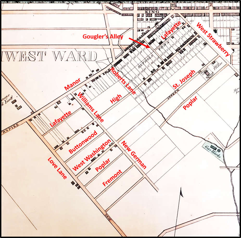
Streets on Cabbage Hill in the mid to late 1850s, shown on an 1858 map. From T.J. Kennedy’s Map of Lancaster.
Manor
Street, the oldest street on the Hill, was already a well-traveled Native
American trading trail when Lancaster was founded in 1729. It was known as the
Blue Rock Road in the mid to late 1700s, because it led to an early ferry
across the Susquehanna at Blue Rock just south of Washington Boro. In the early
1800s, the southwestern stretch of the street was often called the Manor
Turnpike, because of the toll levied on travelers as they crossed the
southwestern city limits. Finally, in the mid-1800s, the street became known as
Manor Street.
West
Strawberry Street is the second oldest street on the Hill, having been a dirt cowpath
that marked the southwest edge of central Lancaster when James Hamilton laid
out his building lots in 1729. It was known as Slab Alley as late as the 1840s
and then in the early 1850s, it became West Strawberry, to distinguish it from
its continuation known as East Strawberry on the other side of South Queen
Street.
On the opposite
end of the historic core of the Hill, Fairview Avenue has been around a long
time as a connecting road to South Prince and South Queen at Engleside. From
the mid-1800s to 1915, it was called Love Lane, and it has been Fairview Avenue
since then. The change of name to Fairview makes sense because it runs along a
ridge from which expansive views were possible. I can find no explanation for
its first, more amorous, name.
High Street
originated with the founding of Bethelstown in 1762 when building lots were
laid out on either side of its first two blocks (400 and 500 blocks). By the
1850s, High had been extended southwest to Love Lane, bridging the small stream
at the bottom of the hill where New Dorwart is today. Presumably it was called
High because of the location of the 400 block on a high point known as Dinah’s
Hill.
St. Joseph
Street has a complicated naming history. The 400 block of St. Joseph was
established in 1850 when St. Joseph Catholic Church was built. At the time the
church was built, the street it fronted was called Union Street (not to be
confused with today’s Union a few blocks to the southeast, which didn’t exist
yet). Then, in the early 1850s, just to make things even more confusing, the
street was sometimes referred to as Poplar Street (before today’s Poplar a
block over was established). Finally, by the end of the 1850s, the 400 and 500
blocks were renamed St. Joseph. However, at that time, St. Joseph did not
extend beyond what is now New Dorwart, and in the meantime the 700 block
between Fairview and Laurel had been laid out, and the street there was known
as West Washington Street. In the late 1850s, when the two streets were
connected by the building of a bridge over the small stream at the future New
Dorwart, the entire street became known as St. Joseph.
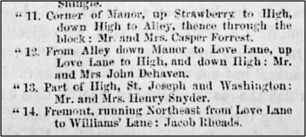
Part of an article establishing Block Committees in the Southwest Ward, in which the early names of some streets are referred to; from the Daily Evening Express, December 15, 1857.
Now that
we’ve brought up Poplar Street……When St. Joseph Church was built in 1850, the
small alley behind the church with no houses on it had no name. In the late
1850s, it became Poplar and it was extended to the stream at the bottom of the
hill at about the same time the future 700 block of Poplar was laid out on the
far side of the stream. In 1870, building lots were laid out on the east side
of the 400 block of Poplar. A year later, on the other side of the stream, the
700 block was named Poplar Alley. In the late 1870s, the street was connected
with a bridge over the stream, and the whole street was named Poplar Street.
Moving
farther east, Fremont Street was established in the late 1850s, starting with
the 700 block between Fairview and Laurel. In 1870, when the building lots were
laid out along the 400 block of Poplar, so too were building lots on both sides
of the 400 block of Fremont. In the early 1870s, the two ends of Fremont were
connected by completing the street in between them. Like Love Lane, I don’t know
the origin of the name of Fremont Street, although when the street was first
laid out in the 1850s, John C. Fremont was a popular national personality who
had been an explorer of the West and then the Republican opponent of James
Buchanan in the 1856 presidential election.
Now heading back
to the west……West Vine Street started as a narrow alley behind the
Bethelstown lots that fronted on the southeast side of High in 1762. The first
inkling of the street that would become West Vine was born between Fairview and
Laurel, where Buttonwood Alley was established in the late 1850s. When the
blocks to the northwest up to West Strawberry were established by the 1880s,
they were called Buttonwood Street. Buttonwood was renamed West Vine in 1890 as
the southwestern continuation of the older West Vine on the other side of West
Strawberry.
Next, to a
street that cuts across the Hill from the northwest to the southeast—Laurel
Street. It was first named in the early 1850s when it was a private lane
providing access to the 25-acre property of John Williams between Manor and St.
Joseph, and naturally enough it was called Williams Lane. In the 1860s, it was briefly
known as New German Street, and then just New Street, and by about 1870, it
became known as Laurel Alley, possibly named for local vegetation. From about 1885
to today, it has been Laurel Street.
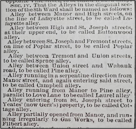
Part of an article describing the city’s plan for naming alleys in the 8th Ward; from the Intelligencer Journal, November 21, 1871.
Another
northwest-southeast street is Filbert Street. From the establishment of
Bethelstown in 1762, there had always been an alley where the first block of
Filbert is now. In the late 1850s to early 1860s, it was known locally as
Gougler’s Alley, so named because of the house of Jacob and Rebecca Gougler at
its intersection with Manor. But it wasn’t until 1871, when the city named or
renamed all its alleys, that it became Filbert Alley. About 1890, Filbert Alley
was promoted to Filbert Street. Because of irregular property boundaries near
the old St. Joseph Cemetery, Filbert had to be offset slightly at St. Joseph
Street.
Another
alley that eventually grew up to be a street is Lafayette Street. In old
Bethelstown, the lots on the southeast side of Manor extended back to meet the
lots on the northwest side of High. They met at a narrow alley that would
eventually become Lafayette Alley. In the late 1850s, houses had started to be
built fronting the alley and the 400 block of the alley was widened to become
Lafayette Street. At the same time, the 700 block of Lafayette was established,
with a gap in the street where the 500 and 600 blocks would soon be. By about
1890, the two developed ends of the street met in the middle, making one
continuous Lafayette Street. The street may have been named for the Lafayette Hotel,
which existed on Manor in the 1840s and 1850s, and backed to the alley that
would become Lafayette.
All the
streets that run from West Strawberry to Fairview had to contend with the small
stream that used to run where New Dorwart is today. For most of those streets,
the last segments to be built (the 500 and 600 blocks) were the ones nearest
the stream. In the 1860s, it appears that a rough path that ran along the
stream valley was known as Roberts Lane, likely named for Anthony Roberts who
owned land nearby. In the 1880s, the city placed a 6-foot-high brick sewer
under the stream, diverted the stream into it, and built New Dorwart on top of
it. New Dorwart was first named South Dorwart, a name that faded gradually over
time and was finally replaced with New Dorwart about the 1920s. New Dorwart had
to be offset at Lafayette, and again at High, because of bends in the
now-vanished stream around which early houses had to be built.
Now, if your
eyes have not yet completely glazed over with all these street names………In honor
of this month’s Valentine’s Day, if anybody has any ideas on why Fairview
Avenue was originally called Love Lane, please comment with your ideas!
Cabbage Hill
once had its very own volunteer fire company. From 1838 to 1882, it served the
West King and Manor Street corridors. Starting very humbly as the Humane Hose
Company, it fought many fires and was a source of much neighborhood pride.
The Humane
Hose Company was established in 1838 by a group of civic-minded citizens of the
west and southwest sections of Lancaster. In August of that year, they
purchased a hose carriage from a company in Philadelphia and paraded it through
the streets of Lancaster, with the “uniform of the members neat and
appropriate” and its members “entitled to much credit for their zeal and public
spirit.”
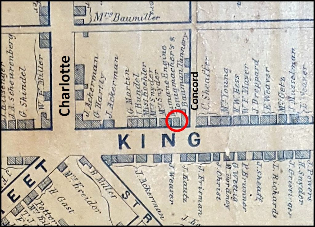
First location of Humane Hose Company on the north side of West King, just west of Concord Alley. From Moody and Bridgens, 1850.
In March
1839, the charter of the Humane Hose Company was approved, limiting the company
to 40 subscribing members and establishing its hierarchy of officers and
directors. The company rented part of a lot on the north side of West King just
above Concord, and built a small frame building in which to keep its hose
carriage.
In the early
1840s, a few of Lancaster’s more established fire companies had their own
horse-drawn, hand-pumper engines, but the Humane only had a hose carriage,
which was simply a large reel holding a wound-up hose on a four-wheeled
carriage. The members of the Humane would pull the carriage to the scene of a fire
using ropes, unwind the hose and hook it to one of the city’s new fire plugs, and
use the hose to fill the tanks of the hand-pumpers of the other companies.
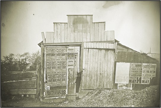
Remains of the first house of Humane Hose Company on West King. Photo taken in early 1880s by George M. Steinman, Humane treasurer, some 30 years after the Humane had moved from the site, and just before the building was torn down in the mid-1880s.
In June
1853, for $225, the Humane purchased the rear portion of a lot on West King to
be the site of their new larger hose house. The Humane’s lot fronted 21 feet on
the northwest side of Manor and extended 30 feet in depth. The Humane built a
two-story brick hose house on the site, approximately where the rear parking
lot for Reveron Electronic, Inc. is today, across from 424 Manor. The hose
house was topped with a bell tower from which fire calls would ring out.
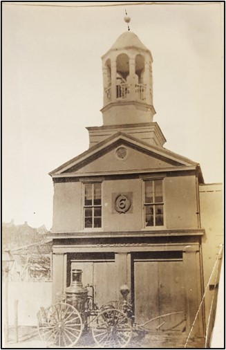
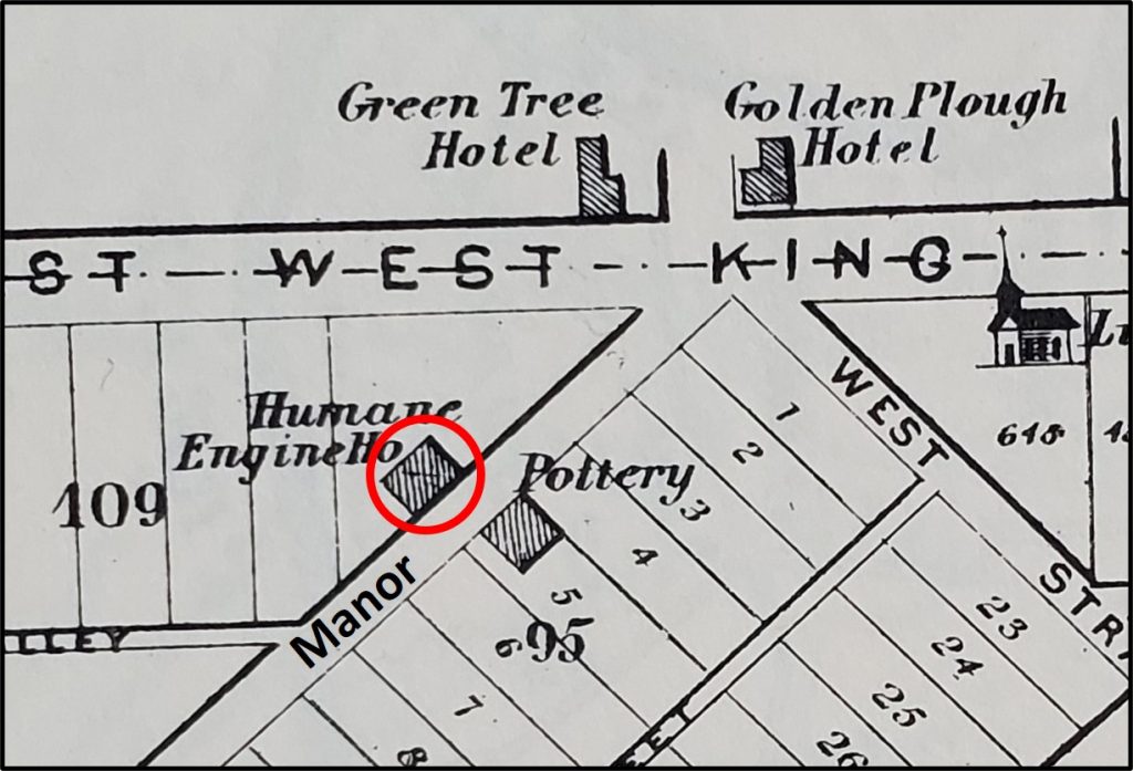
Location of Humane Steam Fire Engine Company No. 6 on Manor Street. From Everts and Stewart, 1875.
At the time
the Humane’s new hose house was built, the company boasted 75 active members.
Only six were property owners; the others were minors or those “who earn their
bread by hard labor”. Their hose carriage had become old and was in need of
repair, eight sections of hose were deemed too old to function dependably, and
the company was $550 in debt. Other volunteer companies also were struggling
with hose problems, and in 1854, the city allocated $3,000 to be shared among the
Humane and four other companies for the purchase of new hoses.
Humane Steam Fire Engine Company No. 6 on Manor Street, about where the rear parking lot of Reveron Electronic, Inc. is today, across from 424 Manor. This house was built in 1853, and was the home of the company for about 25 years. Note the steam-pumper fire engine proudly displayed in front of building. The Humane bought their steam-pumper in 1867, so this photo was likely taken shortly after then. Photo from collection of George M. Steinman, treasurer of the company.
By 1857, the
Humane’s situation had improved to the point that it was able to purchase its
first engine—a used hand-pumper purchased from the Union Fire Company for $300.
The hand-pumper engine was a metal tank mounted on a horse-drawn, four-wheeled
carriage. In the tank, which was filled with water, was a set of pistons that
were operated by long horizontal levers called brakes extending from either
side of the carriage. Teams of men moved the brakes up and down in rapid
succession to activate the pistons, drawing water in from a hose connected to a
water source with one stroke, and then driving the water out under pressure
through a hose leading to the site of the fire with the next stroke.
The Civil
War had a major impact on the Humane. The call for soldiers drew on the same
pool of young men who were active in the Humane. In early September 1862, about
10 days before the Battle of Sharpsburg (Antietam), the Governor of
Pennsylvania asked for all able-bodied men to start military drills in their
neighborhoods, as the Confederate Army was moving north to invade the state. As
a result, a large number of men from the “Hill” met at the Humane’s hose house
to get organized. One of the speakers noted that 69 of the Humane’s volunteers
had become soldiers and that only 18-20 volunteers were still available locally
to fight fires.
By the
mid-1860s, the Humane decided that it should have a steam-pumper like the one
the Union Fire Company had recently acquired. A steam-pumper consisted of a
steam boiler mounted on a horse-drawn, four-wheel carriage. The steam boiler
was used to pressurize the water, forcing a stream of water through a hose
directed at a fire. In 1866, the members of the Humane began canvassing the
neighborhood for subscriptions to buy a new steam-pumper.
In early
January 1867, after enough money had been pledged, a committee was appointed to
purchase a steam-pumper. The committee went to Philadelphia to purchase the new
apparatus, and a couple weeks later the new steam-pumper was delivered to
Lancaster. The steamer was purchased for $2,800 from the Undine Steam Fire
Company of Holland, New York, and had been built by A.B. Taylor.
On a cold January
day, a parade was held to deliver the new steamer to the Humane’s house on
Manor. Six Lancaster fire companies were represented, in addition to 75 men
from the Humane. After the parade was over, the men of the Humane were anxious
to see their new engine perform, so they took it back down to the square, where
they fired it up and threw a stream of water 200 feet up North Queen.
In the early
1870s, the Humane is said to have declined in membership, and was saved from
folding only by a reorganization in late 1875. Hugh Fulton was elected
President, and the company officially modified its charter in April 1876,
taking on the unwieldy new name of the Humane Steam Fire Engine and Forcing-Hose
Company No. 6.
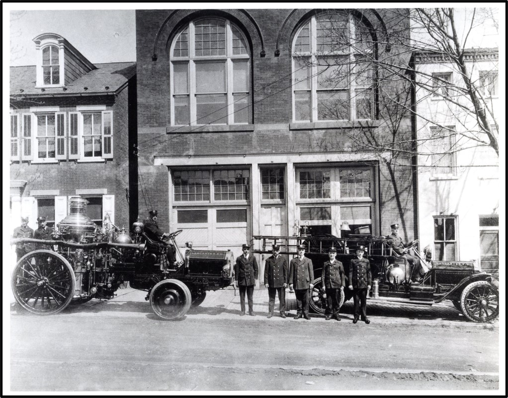
Lancaster City Fire Department Station House No. 1 in 1918. This house was completed in 1880 as the engine house of the Humane Steam Fire Engine and Forcing-Hose Company No. 6. The building is now occupied by Station One Center for the Arts. Photo courtesy of Ryan Conklin, Lancaster City Fire Department.
The
revitalized Humane decided to move out of its aging house on Manor. A lot was
purchased for $2,100 not far away on the north side of the 400 block of West
King, and the foundation for a new larger building was laid there in 1878. The
new engine house cost almost $5,300, and was completed in 1880. It still stands
at 411 West King and is currently occupied by Station One Center for the Arts.
The grand
opening of the new West King engine house in October 1880 was marked by a ball
attended by 150 couples. The ball was held in the large second-floor room of
the new house, which measured 40 by 100 feet. The newly energized version of
the Humane seemed to be on its way, but within about two years, it went out of
business when Lancaster City decided to take over the firefighting services
that had heretofore been handled by the numerous volunteer companies.
In April
1882, the new city fire department was established, and in June 1883, the city
purchased the Humane’s three-year-old house on West King for $5,200. The city
designated the house on West King as its Station House No. 1, which would
remain in use for many decades.
The Humane
Hose Company on Manor is now a forgotten ghost of old Cabbage Hill, but in its
time it was a formidable firefighting organization that helped protect the
Hill’s buildings for some 40 years, as well as an important part of the Hill’s
social scene.
We are hiring! We are seeking a dedicated community member to serve as a Housing Location Specialist. The Housing Location Specialist will develop and maintain working relationships with Lancaster landlords and property managers for the purpose of locating and securing housing for residents residing in Southern Lancaster City
Housing Location Specialist (part of the SoWe program)
Tabor Community Services, a
non-profit community benefit organization providing programs and
services to foster housing and financial stability in Lancaster County,
PA, is seeking qualified candidates for a
full-time Housing Location Specialist employed and supervised by
Tabor/LHOP as part of the SoWe program.
The Housing Location Specialist
will develop and maintain working relationships with Lancaster
landlords and property managers for the purpose of locating and securing
housing for residents residing in Southern Lancaster City. For the full
list of functions, please read the full job description.
Key Qualifications include:
2 years of post-secondary education required; Bachelor’s degree preferred.
One year of relevant experience required; two or more years preferred. Experience working in rental housing field preferred.
Commitment to housing as a human right.
Negotiation and sales skills are essential.
Ability to understand the
interests and concerns of landlords/property managers, and develop
effective working relationships with them.
Knowledge of available affordable rental housing in the County, building codes and safety standards for rental housing.
Knowledge/understanding of tenant’s rights and responsibilities
Excellent communication skills especially in listening and mediation.
Strong organizational skills with ability to meet a demanding workload.
Detail-orientated to complete requirements of files and contract compliance.
Ability to speak, write, and understand English is required; fluency in Spanish preferred.
Proficiency using computers and Microsoft Office.
Sensitivity to cultural and socio-economic characteristics of population served.
The ability to establish and maintain respectful relationships and healthy boundaries with residents.
The ability to work collaboratively with other personnel and/or service providers.
Valid driver’s license, a car, and willingness to travel in the community
Qualified applicants should
send, via e-mail (preferred) or U.S. mail, a letter detailing their
interest and qualifications, resume, and the names with contact
information for 3 references to:
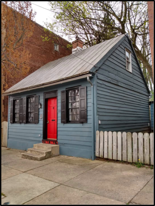
One of the better-preserved
one-story houses in Lancaster is the blue house with the red door at 434 West
King Street. This four-bay, center-chimney, Germanic-style house is typical of
the many hundreds of such houses, also sometimes known as one-and-a-half-story
houses, that once dominated the architecture of the city during the Federal
period of the late eighteenth and early nineteenth centuries. The 550-square-foot
house is located on the very northern edge of the SoWe project area, less than
a block outside of Cabbage Hill.
434 West King Street. Photo courtesy of its current owner, David Aviles Morales.
How old is
the house? Who built it? Who owned it over the years? There is not much
information available to answer these questions, and what little exists is somewhat
contradictory. Real-estate websites date the house as early as the 1790s and as
late as 1880. A 1985 survey by the Historic Preservation Trust and a 1995
report by the City of Lancaster both refer to the property as the Geise House
and date it to about 1840. But an old map and tax records show that a Barbara Geiss
owned the house next door instead. To try to resolve these conflicts and answer
the questions above, extensive research into historic deed, tax, directory,
newspaper, and other sources was undertaken.
The result
of that research indicates that 434 West King has an interesting and fairly
complicated history. Construction of this venerable old one-story frame house probably
was completed in 1817. The lot where the house is located was originally 64
feet wide along the south side of West King and 245 feet deep to what would
eventually become Campbell Alley. The house’s early history is closely tied to
the Eberman family, a prominent family in Lancaster in the late 1700s.
John Eberman
III (1776-1846) probably began building the house at 434 in late 1816. John III,
a cashier and bank treasurer, was the son of John Eberman, Jr. (1749-1835), a
famous clockmaker whose clocks are highly valued today. John, Jr. also was a
prominent Lancaster citizen who served as Chief Burgess and Justice of the
Peace, and as a sergeant in the Revolutionary War. John, Jr. made and installed
the four-dial clock in the steeple of the second courthouse in the square about
1785. John, Jr.’s father, John Eberman, Sr. (1722-1805), was a soap boiler and
tallow chandler who immigrated to Lancaster from Germany in the mid-1740s. The
Ebermans were a prolific family: John, Sr. had 12 children, John, Jr. 13, and
John III 10.
Part of the Lancaster County tax list for Lancaster Borough for 1817, the first year that 434 West King was on the tax rolls. Note that John Eberman, the owner, had taken in “P. Sugar’s” as a tenant in his “unfinished” house. The four numbers at the end of the entry denote 1 house, 1 lot, 63 shillings ground rent, and $250 assessed value.
Several
members of the extended Eberman family owned 434 from 1816 to 1838. Before John
III had even completed the house, his first tenant moved in. Tax records show
that John III rented the house “unfinished to P. Shugar’s” in 1817. (Presumably
John III and/or Shugar completed the house shortly thereafter.) Peter Shugar
was related to John III through marriage; he had married John III’s aunt,
Elizabeth Eberman, in 1796. Upon marrying into the Eberman family, Shugar took
over the aging John, Sr.’s soap and chandler business. The Shugars had six
children.
Unfortunately,
Peter Shugar, whose surname was later anglicized to Schucker, died a couple
years after moving into 434. Immediately after Peter’s death, his wife
Elizabeth bought the house, which was valued at $250, from her nephew, John
III. A few years later, in 1823 or 1824, Elizabeth divided the lot into two,
keeping 434 on the western half of the lot for herself and selling the vacant eastern
half of the lot back to her nephew, John III. By 1829, John III had built a
one-story frame house on the eastern half of the lot, the house number for
which would eventually be 430. (This house, which had a brick front and was a
little larger than 434, was torn down around 1900 and replaced with the three-story
building that now stands to the east of 434.)
In 1830 or
1831, the ownership of 434 became more complicated. Elizabeth Shugar sold the
house to Jacob Eberman, a shoemaker who was Elizabeth’s nephew, the son of her
older brother Philip. Jacob was also Elizabeth’s son-in-law. He had married his
first cousin, Peter and Elizabeth’s daughter Sarah Shugar, in 1824. Jacob’s
ownership of 434 did not last very long. By 1832, Jacob and Sarah and their
children had moved to Wooster, Ohio, selling 434 to Jacob’s cousin William
Eberman, the son of John, Jr., the clockmaker, and the younger brother of John
III. (Jacob and Sarah would return to Lancaster about a year later, and live in
a one-story house on West King across from 434.) William Eberman, who bought
434 from Jacob, was a tinsmith and an innkeeper. William also bought the house
at 430 at the same time.
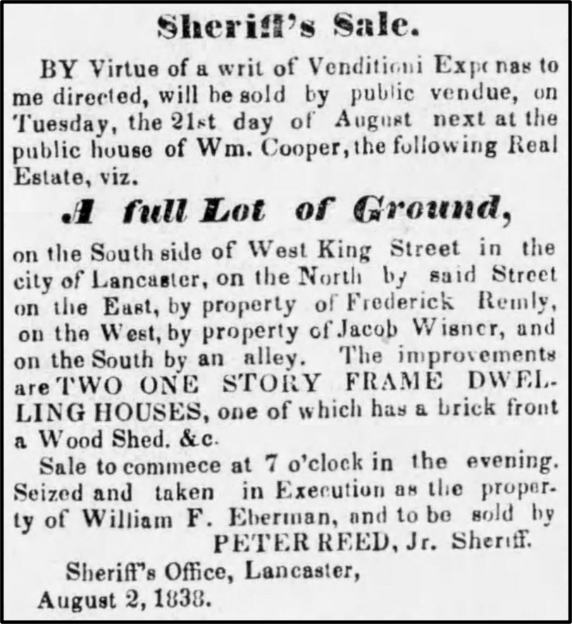
Advertisement in the Lancaster Examiner, August 16, 1838, describing the public sale of William Eberman’s two houses, one of which was the house at 434 West King.
William
Eberman owned 434 and 430 until 1838 when he apparently ran into financial
trouble and was forced to sell the two houses to pay off his debts. Dr. Charles
Herbst, a pharmacist, bought both houses at a public sale in September 1838. In
a newspaper advertisement for the sale, the houses were described as “two one
story frame dwelling houses, one of which has a brick front a wood shed etc.”
on a “full lot of ground on the south side of West King Street.”
Charles
Herbst sold both houses on April 1, 1840. The house at 430 was sold to Barbara
Geiss, a widow with a young son, for $475. The house at 434 was sold for $425
to Margaret Gantz, a widow who had two children. At about the same time widow
Gantz bought 434, she remarried, to Joseph Kunkle. Joseph Kunkle was a peddler,
and he and Margaret had four more children together over the next decade.
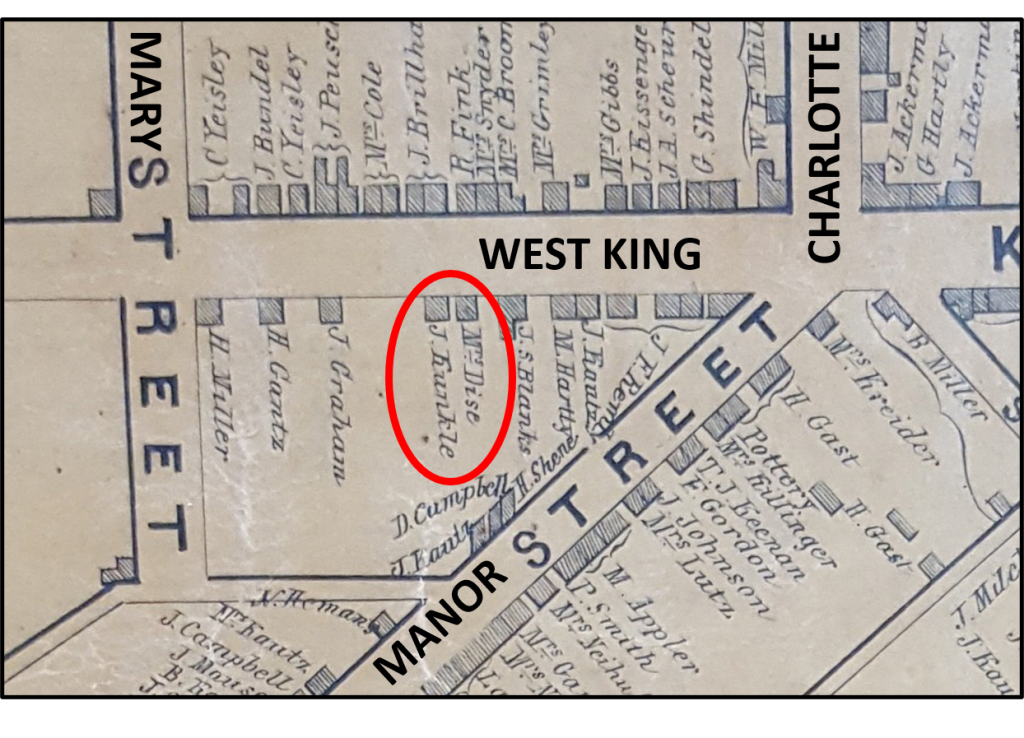
1850 map showing the house at 434 West King and its owner J. (Joseph) Kunkle. Also shown is the house next door at 430 West King and its owner Mrs. (Barbara) Geiss (misspelled Dise). From Moody and Bridgens.
Joseph Kunkle
died in the mid-1860s. His wife Margaret continued living in 434 until her
death in 1890. Margaret’s will stipulated that her daughters Mary and Rose were
to continue to live in 434 as long as they wished. The two sisters lived there
following Margaret’s death for five years until Rose came down from the attic
level one day to discover her sister Mary dead in the summer kitchen.
Rose Kunkle continued
living in 434 until she married Leo Myers in 1909 and moved with him to St.
Joseph Street, where Leo ran a grocery store. (Leo Myers’ grocery was located
in the recently-painted light green house on the corner of Filbert and St.
Joseph Streets, with “Welcome to Cabbage Hill” painted on its side.) When Leo
died in 1913, Rose moved back to 434, living there alone until her death in
1929.
After Rose’s
death, the administrator for Margaret Kunkle’s estate sold the house at public
sale to Sarah and Jack Winkoff, who paid $4,380 for the house and half lot. An
advertisement for the public sale stated that the “Lot fronts 33 feet on the
south side of West King street…” and “The improvements consist of a 1 ½ story
frame house, with six rooms.”
The Minkoffs
rented out 434 until 1965, when they sold it to Ronald Cook, who lived there
until 1973, when he sold it to Carol Miller, who lived there into the 1980s. The
current owner is David Aviles Morales, who has maintained it without changing
its basic historical appearance. The house is now available for booking as an
Airbnb rental.
So, to
answer the earlier questions: 434 West King was built about 1817 by John
Eberman III. For a 203-year-old house, it has not had very many owners, with
the Eberman, Kunkle, and Minkoff families accounting for nearly 150 of those years.
A good name for the house might be the Eberman-Kunkle House, in honor of its
builder and the family that owned it the longest.
As a
survivor from an earlier time in Lancaster’s history, 434 West King reminds us
of what much of Lancaster used to look like. Hopefully, it will continue to
have owners dedicated to its preservation, and serve as a reminder of our
history for many years to come.
Support SoWe and Lancaster Housing Opportunity Partnership during the 2020 Extra Give on Friday, November 20th. Since 2016, Lancaster Housing Opportunity Partnership has been intentionally working with the residents of South West Lancaster City. The goal of the SoWe initiative is to stem the tide of disinvestment and create a neighborhood that is safe, attractive to economic investment, full of opportunities for residents, and welcoming to visitors. This has been a challenging year for neighborhood residents due to the COVID-19 pandemic. SoWe has worked hard with our collaborative partners to ensure residents have the resources and opportunities they need to thrive.
SoWe is excited to the announce the opening of Culliton Park on November 20th to the public. Donate during the Extra Give to support our community! Just put a note with your online gift: SoWe (your gift will be designated to SoWe).
Cabbage Hill
has been home to many successful businesses over the past 150 years, some of
which have succeeded over several generations. Kunzler & Company, Inc. may
be one of the first to come to mind. But not all successful Hill businesses
lasted that long. One of the most successful businesses was the Helvetia
Leather Company, which is largely forgotten today. However, in the latter half
of the nineteenth century, working out of a large lot on Poplar Street, the
company achieved nationwide recognition for its unique products, but it was in
business for only about 30 years.
In the
mid-1870s, Albert Wetter, a Swiss immigrant living on West Strawberry near
South Water, began experimenting with a new way to make leather. By 1879, he
had patented his new method, which used hot air instead of tannin to make
leather from animal hides. Soon Wetter’s new method attracted several investors
and together they started to manufacture “Helvetia leather”, a tough but
pliable leather that was well suited to manufacturing applications. (Helvetia
was the Roman name for Switzerland, Albert Wetter’s native country.)
The new
venture, known by the names of its largest investors, Potts, Locher, & Dickey,
needed a place to conduct its business. In 1879, Wetter purchased a large lot
on the southeast side of the 500 block of Poplar, where the houses at 520-538
are located today. The lot extended 202 feet along Poplar, and 87 feet to an
alley that is now South Arch. Later, the company would purchase another lot
adjacent to the first, this one fronting on Fremont 100 feet and extending 85
feet to the same alley from the opposite direction.
Wetter and
his partners built a large two-story brick factory and associated frame and
brick buildings in which they started producing leather using Wetter’s new method.
The factory was powered by a steam engine using coal as its fuel source. Wetter
purchased the house next door at 518 Poplar in 1880 and he, his wife Lizzie,
and their son Robert moved in beside the factory. In 1882, Wetter enlisted the
noted Lancaster inventor, Anthony Iske, to design machinery that would make the
hot-air method of producing leather more efficient, and together they patented
that machinery. The company began to make a name for itself in the heavy-duty
leather field.
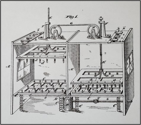
Diagram from patent application for “Machine for Treating Leather with Hot Air”, U.S. Patent No. 266,695, October 31, 1882, by Anthony Iske and Albert Wetter.
Ever since
its founding in 1729, Lancaster had always had numerous tanneries. Tanning
leather was a difficult and messy process. Fresh animal hides had to be
purchased from butcher shops and farms, and they had to be cleaned, de-haired,
cured, and dried for several weeks before they were ready to be tanned. Tanning
usually was accomplished through the use of tannin, which was obtained from
tree bark through a time-consuming process, but with Wetter’s new hot-air
method, that part of the process could be avoided.
Even so, the
tanning that took place on Poplar must have been a dirty, noisy, smelly
activity, becoming especially bothersome as that block of Poplar was built out with
houses in the 1880s. Also, tanning no doubt resulted in some nasty waste
products that were drained off downhill into the small stream that ran where
New Dorwart is located today. Following the burial of that small stream in a
sewer under New Dorwart by the late 1890s, the company built their own sewer to
connect to the one under New Dorwart, and discharged their waste that way.
Unfortunately,
due mostly to bad management, the first incarnation of Wetter’s business failed
after a few years. Wetter and his partners were forced to sell the Potts,
Locher, & Dickey business in 1882. The business was bought by a different
group of investors headed by John Holman and Philip Snyder. After a few years
of gradual success under its new management team, the business went public on
September 7, 1886, sold shares, and became a corporation called the Helvetia
Leather Company. (Wetter was not part of the newly incorporated business; in
fact, he seems to have left Lancaster.) The growing company, chartered for the
purpose of “tanning and manufacturing leather by patented or other process”,
soon became famous for its leather, which was ideal for belts in machinery,
laces for boots and shoes, industrial aprons, and similar uses.
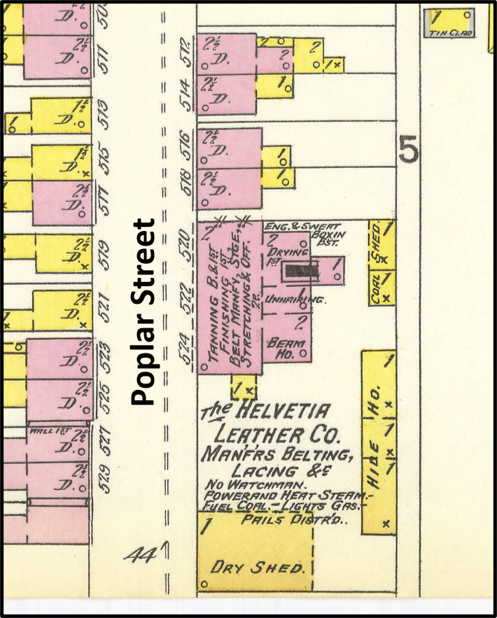
1897 map showing the Helvetia Leather Company complex at 520-534 Poplar Street; from Sanborn fire insurance map
The
nationwide recognition of the company was mainly due to its belt leather, that
is, belts used to run heavy-duty machinery in sawmills, cotton mills, silk
mills, printing plants, iron forges, railroad shops, and similar factories.
Helvetia leather was made only from the high-quality centers of the animal
hides, with the edges being cut off and sold to other manufacturers of different
leather products. The company’s leather belts were said to be strong yet
pliable, no matter their thickness, and they could run machinery with less
tension required than with other types of leather belts. The company’s belts
performed equally well in cold and hot temperatures, and did not slip as much
as others.
The Helvetia
Leather Company made heavy-duty leather belts for factories as far west as
South Dakota, as far south as the Carolinas, and as far north as Massachusetts.
Companies such as the Lehigh Valley Railroad Company, the Nonotuck Silk Mills,
the Lancaster New Era, and the Clark Mile End Spool Cotton Company installed
belts made by the Helvetia Leather Company. In fact, the Clark Mile End Spool
Cotton Company in Massachusetts used nearly two miles of Helvetia belting in
its factory, with one single belt being more than 2,100 feet long, a record for
the time.
Throughout
the 1880s and the 1890s, the Helvetia Leather Company on Poplar flourished
under the leadership of John Holman and Philip Snyder, as well as several other
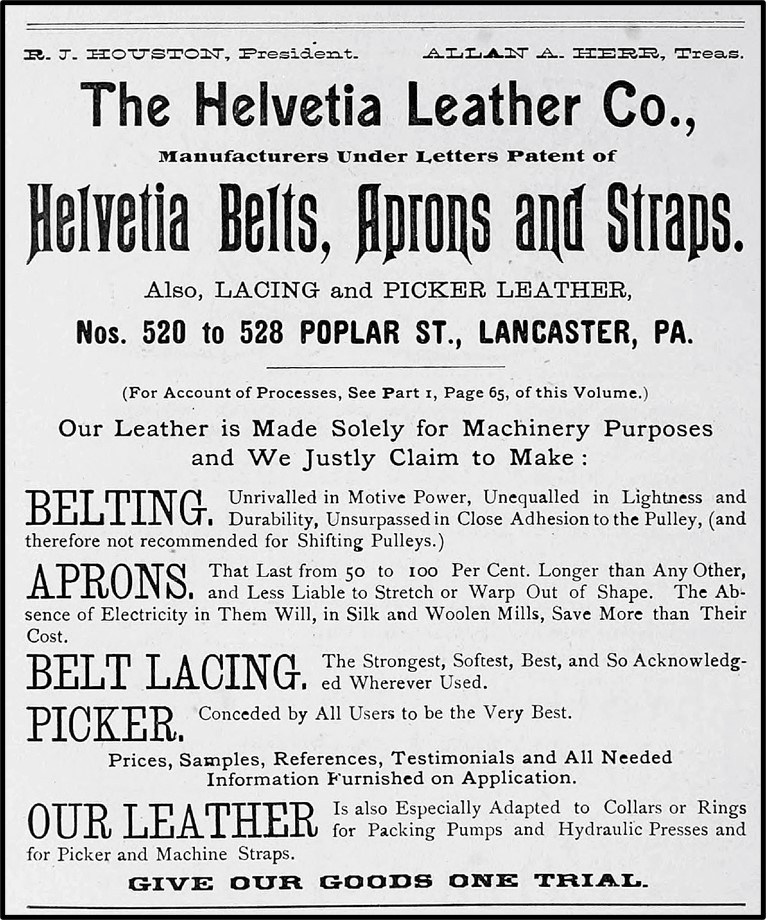
prominent Lancaster businessmen. Robert Houston was President for most of those
years, and local businessmen Allan Herr, Abraham Rohrer, Charles Landis, Elmer
Steigerwalt, and Benjamin Atlee played important roles in officer positions.
Gustavus Groezinger, owner of Groezinger’s Tannery at the foot of West
Strawberry, also was an investor and officer. For many years, John Zercher was
the factory superintendent, until he died suddenly at his desk one morning in
1906.
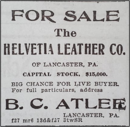
Advertisement for public sale of Helvetia Leather Company in 1909.
By the first
decade of the twentieth century, Helvetia Leather Company had trouble paying
its shareholders their annual dividends because of high prices for raw
materials. By the end of the decade, the company struggled to meet expenses, no
doubt partly because of the rising popularity of rubber belting. As a result,
the company was put up for public sale in 1909, but the reserve amount was not
met. It was finally sold in 1910 to Henry Schneider, and its buildings were almost
immediately razed to make room for new houses. Within two years, eight two-story
brick houses had been built at 520-534 Poplar.
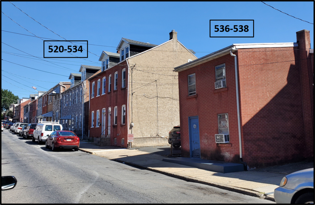
Building at 536-538 Poplar that was once part of the complex of buildings of the Helvetia Leather Company tannery and factory. The eight two-story houses at 520-534 Poplar, just uphill from 536-538, were built about 1911 where the factory and other buildings once stood.
Two small,
unusual houses at 536-538 Poplar are all
that remain of the Helvetia Leather Company’s complex of buildings; these two
houses used to mark the southwestern extent of the tannery property. Looking at
the row of eight tidy houses just uphill from 536-538 now, it is difficult to imagine
that, in their place, a large, busy, noisy tannery once produced machinery
belts and other products that helped run factories all around the country.
Today, the Helvetia Leather Company is just another ghost of Cabbage Hill past.
The
five-point intersection of West Strawberry, South Mulberry, and West Vine
Streets, which is the gateway to Cabbage Hill from downtown Lancaster, has
witnessed a lot of history. On the northeast corner of the intersection,
bounded by South Mulberry and West Vine, a large school building now stands on
a lot where 170 years ago some of the very first schools of Lancaster’s
public-education system once stood. Let’s peel back the layers of school history
at this site, starting with the first layer (today) and working back to 1850,
with the emphasis on the fourth (earliest) layer, about which less is commonly
known.
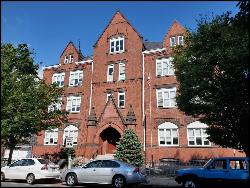
Layer 1,
1992-2020–The first
and most recent layer of school history at this intersection covers 1992 to the
present. Housed in the large Victorian-era brick building on the northeast
corner of the intersection is the Intensive Day Treatment Program run by
Catholic Charities of the Harrisburg Diocese. The program offers a
five-day-a-week program of counseling, therapy, and life-skill education for
at-risk Lancaster County children between the ages of nine and fifteen.
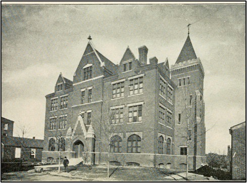
The Victorian-era school building on the northeast corner of South Mulberry and West Vine. Photo taken in 2020.
Layer 2,
1939-1992–The second
layer of school history, just beneath today’s surface layer, covers 1939 to 1992.
Many long-time residents of Cabbage Hill will remember this layer, when the
current large brick building was the home of St. Joseph Catholic School. The
Harrisburg Diocese bought the building on behalf of St. Joseph Catholic Church
on July 10, 1939, and established a parochial school for the education of
Catholic children on the Hill. The diocese purchased the building from the
Lancaster City School District for $22,500 and renovated it to meet St. Joseph
Church’s needs. The purchase was made to ease the crowding of the school located
next to St. Joseph Church a block away. Many Cabbage Hill children received
their primary-school education at St. Joseph School.
Layer 3,
1892-1939–Peeling
back the second layer of school history, we expose the older third layer, which
covers 1892 to 1939. No doubt there are a few old-timers who remember at least
the later years of this layer, which begins with the completion of the current
large brick school by the School District of Lancaster in 1892, and ends when
the building was sold to the Harrisburg Diocese in 1939. The building currently
at the site, then known as the South Mulberry Street School, was part of the
City of Lancaster’s public-school system for nearly fifty years, and served as
both a primary and secondary school. It was built to accommodate the growing
numbers of students that resulted from increased immigration to the Cabbage
Hill area in the late nineteenth century.
The
architect who designed the South Mulberry Street School (1892) was James H.
Warner, who also designed several other prominent buildings in Lancaster at
about the same time, including Central Market (1889) and Christ Lutheran Church
(1892). It is not surprising that the exterior of the South Mulberry Street
School bears a strong resemblance to the exteriors of these other two buildings,
in that all three are built in similar Victorian style with red brick
highlighted by decorative brownstone accents.
Also built
about the same time and in similar style was the three-story Victorian-era
brick building on the corner across West Strawberry that until recently housed
the Strawberry Hill Restaurant, and was originally the Centennial Hotel. In
addition, the grouping of three three-story brick houses diagonally across the
intersection, and directly facing the intersection on the south corner, was
built in the 1890s. The late Victorian makeover of the intersection was
complete by the late 1890s.
Layer 4,
1850-1892–Finally, way
down in the layers of school history at this site is the fourth and earliest
layer. It begins in 1850 and ends in 1892, when the large school building now
on the site was completed. To clear the ground for the large current building,
the School District of Lancaster razed two older school buildings built in 1850
and a third school building built in the late 1860s. All three of the earlier
buildings were one-story brick buildings, with the third building being
slightly larger than the first two.
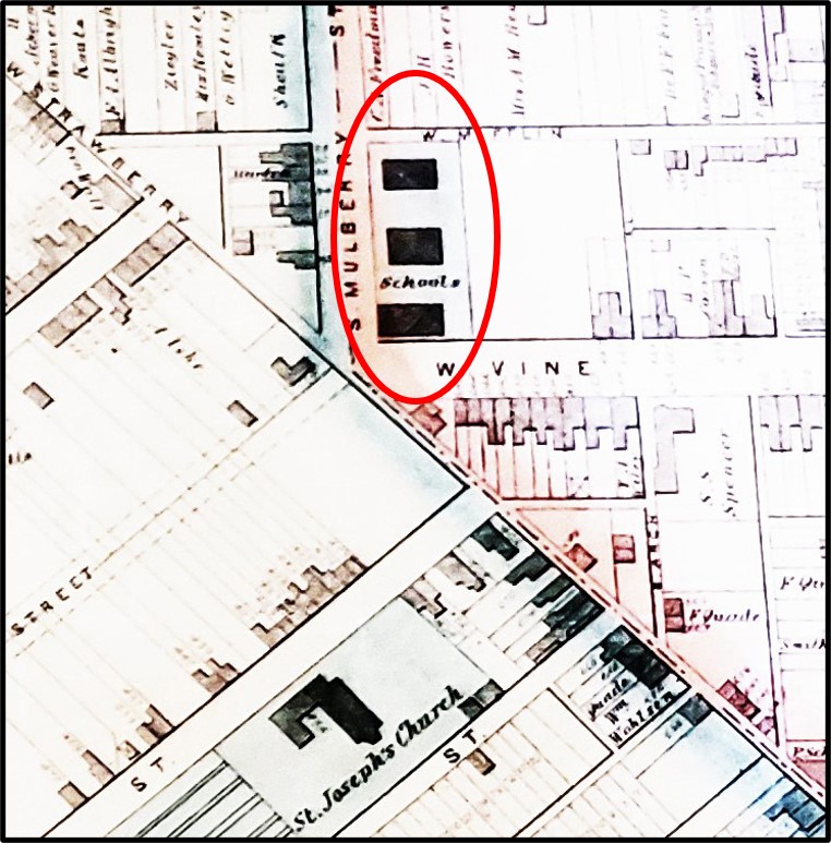
Map showing the three school houses in 1874. The third, slightly larger, school house had just recently been built. Note that West Strawberry was still a narrow lane, and the southern West Vine extension was just being laid out. From Roe and Colby, Map of the City of Lancaster, 1874.
The first
two of these early school buildings were among the very first public-school
buildings built in Lancaster following the implementation of the city’s common
(public) school system in the early 1840s. The first two buildings—essentially
double one-story brick houses—were built in 1850. They were built on Hamilton
lot 386, one of the original building lots laid out by James Hamilton in 1730.
Lot 386 had been purchased by the Board of Directors of the Common Schools from
Margaret and Catharine Yeates, daughters of Judge Jasper Yeates, on June 26,
1849, for $300. The lot was 64 feet on West Vine, extending 242 feet to
Mifflin.
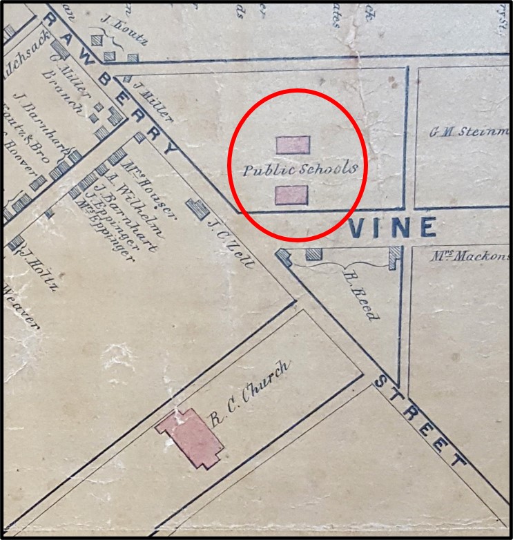
Map showing the first two one-story brick school houses on the north side of West Vine in 1850. Mulberry had not yet been extended south past West Orange, and West Vine had not yet been extended across West Strawberry. St. Joseph Catholic Church had just been built. From Moody and Bridgens, Map of the City of Lancaster, 1850.
At the time
the Board of Directors purchased lot 386 and built the first two school houses,
South Mulberry did not yet exist; Mulberry’s southern extent ended at West
Orange. As a result, the two school houses were referred to as the West Vine
Street School until Mulberry was extended in the mid-1850s. Also, when the
school houses were first built, West Vine did not exist south of West
Strawberry. Therefore, today’s distinctive five-point intersection was only a
three-point T-intersection with the north part of West Vine truncating at West
Strawberry, which was still a narrow dirt lane. In addition, in 1850, the
foundation of the first St. Joseph Catholic Church was just being dug, and today’s
Christ Lutheran Church was still several decades in the future.
Lot 386 was
near the top of Dinah’s Hill and it looked out on downtown Lancaster to the
north and was bounded on the south, in 1850, by pasture land of the still undeveloped
central part of Cabbage Hill. Across West Strawberry to the south was Christopher
Zell’s one-story frame blacksmith shop that would soon be enlarged into the
Centennial Hotel and Saloon. There were only a few other buildings within a
block of the two school houses, including the small log cabin across West Vine
where 113-year-old ex-slave and fortune-teller Dinah McIntire had lived several
decades before, giving her name to the hill on which lot 386 was located.
Enlargement of an 1852 lithograph showing the first St. Joseph Catholic Church and the first two school houses on West Vine. The flattened perspective makes it seem that the school houses are across the street from the church, but they were actually a half block past the church across West Strawberry. Drawing by Charles R. Parsons.
When the
first two small school buildings opened in 1850, they served both primary- and
secondary-age children, mostly of German heritage. It didn’t take long for the
two school buildings to become crowded as Cabbage Hill began to grow.
Anticipating and reacting to that growth, the Lancaster School District acquired
two more pieces of land adjacent to lot 386—a 16-foot strip of land between lot
386 and the recently extended South Mulberry to the west in 1860, and a 24-foot
strip of land on the east side of lot 386 in 1878. Both strips of land extended
to Mifflin.
The third
school building was added to the south of the first two in the late 1860s to
serve as a primary school for both boys and girls. It was a little larger and
sat a little closer to South Mulberry, taking advantage of the strip of land added
in 1860. By the late 1880s, the three small school houses were again becoming
crowded as well as outdated, prompting the School District to plan for their
replacement by a larger, more modern building—the one that is on the site
today.
It would, of
course, be historically interesting to have a photograph of the three early
public-school buildings before they were torn down in the early 1890s, but it
seems there are none devoted to just the three buildings themselves. However,
partial images of the first school houses on the site were inadvertently
captured in the corners of two other photographs before the early school houses
were forever lost to history.
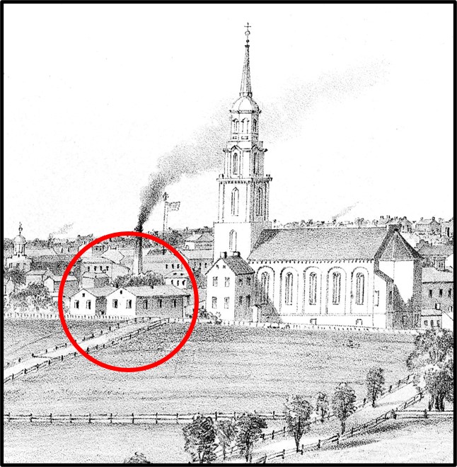
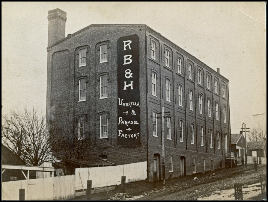
Photograph of Rose Bros. & Hartman Parasol & Umbrella Factory on South Mulberry in the late 1880s. The factory is now the rear one-third of the Umbrella Works Apartments. From LancasterHistory photo archive, no. A-13-01-28.
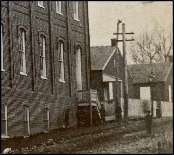
Enlargement of the lower right corner of the photograph to the left, showing the two one-story brick school houses (built in 1850), prior to them being torn down.
First, in
the late 1880s, a few years before the current building was built, a
photographer from the Fowler Gallery took a picture of the Rose Bros. &
Hartman Parasol & Umbrella Factory in the first block of South Mulberry.
This factory would soon be expanded down to West King and become the Follmer, Clogg
& Company umbrella factory, and today the Umbrella Works Apartments. On the
right edge of the photograph one can see the fronts of the first two small,
one-story, brick school houses built in 1850.
South Mulberry Street School, at the completion of construction in 1892. Note the old one-story brick school house, built in 1850, on the left edge of the photograph, and the old one-story brick school house, built in the late 1860s, on the right edge. Photo from Riddle, 1905.
Then, in
1892, when the current larger building had just been finished, a photograph was
taken to commemorate its completion. On the left edge of the photograph can be
seen the side of one of the first school houses built in 1850, and on the right
can be seen the front edge of the third school house built in the late 1860s.
It seems that only the middle school house had to be torn down to build the new
larger school, and the other two were used for classes while the new larger
school was being built. Then, when the new school opened, the remaining two old
school houses were torn down.
One can
learn a lot about the evolution of schools at this iconic five-point
intersection just by using historical records and photographs to peel back the
layers of history.
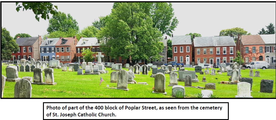
The 400 block of Poplar Street, one of the most picturesque blocks on Cabbage Hill, dates back to October 5, 1872. On that date, at 2:00 p.m., a public sale of building lots was held as part of the estate settlement of Henry C. Locher, the developer of the lots, who had died the previous year.
First, by way of a little background…..In 1872, the central part of Cabbage Hill was in the midst of a development boom, spreading from Manor Street eastward. In the west, the 400 and 500 blocks of Manor and High Streets in the Bethelstown neighborhood were almost completely built up, with the former Lafayette and Buttonwood (West Vine) Alleys beginning to be built on as well. Moving east, the 400 and 500 blocks of St. Joseph Street had acquired houses on about half of their lots. But on Poplar Street, although St. Joseph Catholic Church was on the northwest side, the southeast side of the 400 block was devoid of houses. With the October 1872 sale of Henry C. Locher’s lots, that was about to change.
Thirty-one lots on the southeast side of Poplar had been staked out by Locher and his family in early 1870. All but two of the lots were 20 feet wide by 100 feet deep; the exceptions were the two end lots that were a little wider at 30 and 27 feet. All the lots backed to an alley that would eventually become South Arch Street. The lots were numbered from 7 to 37. Bidders on the lots could bid on single lots or as many as three contiguous lots.
The sale took place across Poplar from the rear of St. Joseph Catholic Church and the adjoining cemetery, which had been established less than 25 years earlier. According to an announcement of the sale in the Lancaster Examiner and Herald: “These lots are pleasantly situated, on high ground, and in an improving and rapidly growing part of the city, and very desirable for building lots…”
The land had been purchased by Henry C. Locher and his wife Cecelia Margaretta from Daniel Harman just two years earlier in 1870. Locher laid out building lots shortly after buying the land, and first tried to sell the lots privately, without success. When Henry died in April 1871, Charles A. Locher was assigned to be the guardian of Henry’s and Cecelia’s youngest daughter, Laura, who was 10 years old and still a minor. The public sale of lots was arranged to generate enough funds to provide for Laura’s share of her father’s estate, to be managed by her guardian until she became of age.
Henry C. Locher was able to invest in real estate because of his successful tannery located at the corner of West Strawberry and South Water Streets, where the wading pool in Culliton Park was until recently located. He and his wife Cecelia and their four daughters lived in a house next to the tannery. The tannery was established by Henry C.’s father and from the late 1830s to the early 1870s, it produced a specialized leather known as Moroccan leather that was made from goatskin.
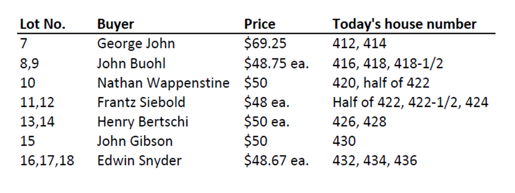
The public sale of Locher’s building lots on October 5, 1872 went well. A dozen lots on the southeast side of Poplar were sold that day, ranging in price from $48 apiece for lots 11 and 12, to $69.25 for lot 7 (the widest lot). The purchasers were required to pay half the price by April 1, 1873, and the other half, with interest, by April 1, 1874. The twelve lots that were sold that day in the 400 block of Poplar were:
The building of houses on the recently purchased lots began shortly after the public sale. Most of the new lot owners kept their lots at the original 20-foot widths, but a few lot owners subdivided their lots before houses were built. Lot 7, with an original 30-foot width, was divided into two 15-foot wide lots. Also, two pairs of 20-foot wide lots, each pair having a total of 40 feet of width, were each divided into three lots a little over 13 feet wide. Lots 8 and 9, and lots 10 and 11, were combined and then subdivided in this way, so that four 20-foot wide lots became six 13-foot wide lots. The result was that thirty-four houses could be built on the original thirty-one lots.
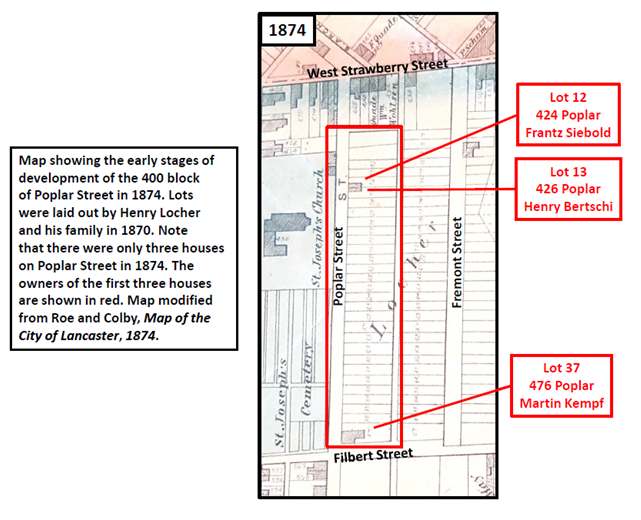
The first two houses to be built were completed by 1874 (see 1874 map). They were built by Frantz Siebold (lot 12) and Henry Bertschi (lot 13). Today those houses are 424 and 426 Poplar, across the street from the SoWe office in the rear of the St. Joseph Church annex. The third house built was that of Martin Kempf, who bought lots 36 and 37 for $475 about six months after the public sale. Kempf built a larger house on lot 37 on the corner of Poplar and Filbert, where he opened a beer saloon on the first floor. Kempf’s house and saloon is now 476 Poplar.
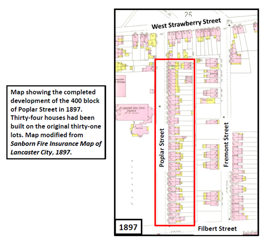
The purchase of lots from Locher’s heirs, and the building of houses on the lots, continued for another fifteen years. In 1880, eight years after the public sale, eight houses had been built (416-424, 476). Just six years later, in 1886, another twenty houses had been built (412-414, 426-430, 434-436, 442-448, 456-472). Finally, by 1888, sixteen years after the public sale, all thirty-one lots had been sold and all thirty-four houses had been built (see 1897 map). Every house was a 2-1/2-story brick Victorian house.
In a little more than fifteen years (1872-1888), the southeast side of the 400 block of Poplar Street had gone from boundary stakes in the ground to fully built out, testifying to the intense development of the Hill that was occurring at that time. Today, the same thirty-four houses that were built more than one hundred and thirty years ago are still present, making the 400 block of Poplar perhaps the only block on Cabbage Hill where all the original houses pre-date 1890 and are still in use.
Today’s residents of the 400 block of Poplar are living with a lot of history just waiting to be discovered. If you live in one of those houses, the history of your property dates back to the lots laid out by Henry C. Locher in 1870. That would be a good starting point from which to develop the rest of your house’s history to the present. If you are interested in researching your house’s history, you can contact me at SoWeCommunicate@sowelancaster.org, and I will try to point you in the right direction.