The City of Lancaster is working with local artist, Fern Dannis, along with Two Dudes Painting Company to create an artful intersection at the Strawberry Hill intersection. This project is part of the Bloomberg Foundation’s Asphalt Art Initiative to create street murals and other creative interventions to improve pedestrian safety and enhance public spaces.
The intersection of West Strawberry Street, West Vine Street, and South Mulberry Street sits at the top of Cabbage Hill. This five-way intersection is a confusing space for pedestrians and vehicles and is integral to the neighborhood and city-wide traffic circulation. Public engagement is beginning June 3rd, with the artwork being designed over the summer. The final application of paint-to-asphalt is set for September 11, 2021.
Cant make the community events but still want to provide feedback? Fill out this survey.
What is an artful intersection? Artful Intersections connect artists and neighbors to work together to create street murals in their neighborhoods. The street murals serve as a reflection of the life and culture of the neighborhood; it is expected to expand the perceived public space to encompass the street; increase awareness and safety of alternative forms of transportation, and boost community development.
To learn more about the project, please visit https://engage.cityoflancasterpa.com. We are asking residents to respond to a community survey to provide input on pedestrian safety and the artwork for the intersection.
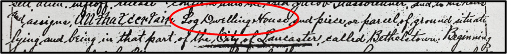
Cabbage Hill
was nothing but forest, farmland, and pasture until 1762 when Bethelstown was
laid out with 66 building lots on the first two blocks of what would become
Manor and High Streets. Bethelstown grew slowly; by 1815, more than 50 years
after its founding, there were only about 25-30 houses on its 66 lots. Nearly
all of the houses were one-story houses made of logs and rough-sawn wood.
Most of the
original houses on Manor and High were later replaced by two- and three-story
brick houses built in the second half of the nineteenth century. However, at
least one of the charter-member houses of old Bethelstown lasted well into the
twentieth century before being razed—a log house with weatherboarding that used
to stand at 442 Manor before it was taken down in 1963 to make room for a
parking lot.
Which raises
the question: Was 442 Manor the only survivor of the original 25-30 one-story
houses from old Bethelstown, or is it possible that more of the original
one-story houses are still present, hiding behind modern vinyl siding and
form-stone? Most of the historical sources needed to answer this question are
available online. The only one not completely online is county tax lists, and
the staff of LancasterHistory was kind enough to supply the lists for the years
not yet online.
Using Google
Maps, I was surprised to discover that 27 one-story houses are still present in
the 400 and 500 blocks of Manor and High. Of the 27, nine are single houses,
fourteen are in seven house pairs, and four are grouped together in a connected
row of houses. Using newspaper articles, city directories, street maps,
property deeds, and other sources, I was able to determine that 20 of the 27
current one-story houses in the first two blocks of Manor and High were built
in 1850 or later, and therefore are not old enough to be original houses from
old Bethelstown. The remaining seven possibilities—two on Manor and five on
High—were investigated in more detail.
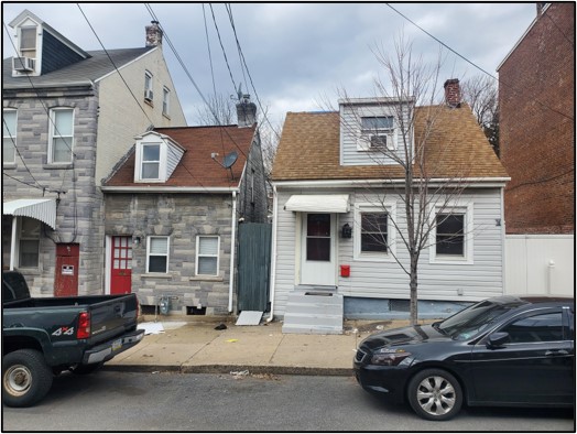
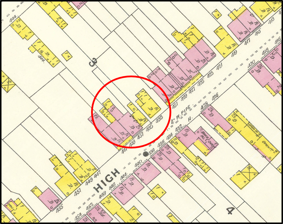
The one-story log house at 433 High (right) and the one-story frame house at 435 High (left). Author’s photo, 2021.
Of the seven
houses that predate 1850, five were found to have been built in the 1840s,
leaving just two—433 and 435 High Street—that had the potential to be old
enough to be original Bethelstown houses. A couple of key deeds and tax records
show that these two one-story houses, which are next-door neighbors on the
northwest side of the 400 block of High, were built on Bethelstown lot 28, and
that both houses were already present in 1840. The deeds show that 433 is a log
house, adding to the potential that it could have been built quite a bit before
1840.
Making
things a little more challenging, detailed maps and city directories do not
exist before 1840, and many pre-1840 deeds that would be helpful seem to have
gone unrecorded or have been lost. Consequently, tax lists took on a more
important role in tracking these two houses before 1840. The continuity from
year to year in the amount of ground rent paid for the lot, as well as the
assessed value of the houses, enabled me to trace 433 and 435 High back in time
before 1840 with some success. Also helpful were occasional notes written by
the tax assessor when the properties were bought or sold.[1]
The result
is that “YES” is my answer to the question of whether any of the 25-30 houses
from the pre-1815 days of old Bethelstown have survived. The weight of the
evidence points to the one-story log house at 433 High as the oldest surviving
house on the Hill. It appears to have been built no later than about 1801, and
possibly earlier. Not surprisingly, because they are neighboring houses on the
same original lot, the one-story frame house at 435 High also is old, having
been built about 1814. I believe these two are the oldest surviving houses on
Cabbage Hill—older by at least a couple decades than Catharine Yeates’ 1838
summer cottage at 613 Fremont, previously considered the oldest survivor.
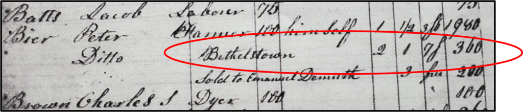
Part of county tax lists for 1840 that shows the properties on which Peter Bier III paid taxes. Note the second listing for Bier, which is for two houses on one lot in Bethelstown. These houses are now 433 and 435 High Street. Bier III paid ground rent of seven shillings on the lot, and the two houses together were valued at $360.
So, who
built these historic houses at 433 and 435 High, and who were their early
owners? The early history of the houses involves a couple generations of the
Bier family. Peter Bier, Sr. (1701-1781) was a German immigrant who arrived in
this country in 1748, bringing with him a teenaged son, Peter, Jr. (1732-1801),
and settling in Lancaster about 1760. Peter, Jr. was a cordwainer (shoemaker)
living in the southeast part of the city, but owning several other houses and
significant acreage, including on the Hill. Peter, Jr. married Elizabeth Buch
in 1760 at First Reformed Church, and they had a son, Peter III (1763-1843).
Peter III also was a shoemaker, but later in life a farmer. Peter III and his
wife Catharine had several children, including a fourth-generation Peter
(1797-1849) who became a doctor.
Peter Bier,
Jr., who died in 1801, appears to have acquired Bethelstown lot 28 shortly
before his death. Peter, Jr. may have built the house now at 433 High as soon
as he acquired the lot, or the lot may have already had the house on it when he
acquired it. If Peter, Jr. built it, the house dates to about 1800-01; if lot
28 already had a house on it when he bought it, the house dates to the late
1700s and was built by an unknown first owner. I suspect the house was already
there when Peter, Jr. bought the lot, because he died within six months, and
probably would not have had the time to build a house. This means the house
likely was built in the late 1700s.
As part of
Peter, Jr.’s estate, lot 28 and the house on it was inherited by his widow
Elizabeth. She may have lived in the house for a short time, but mostly she
rented the house to a series of tenants, including, in the years immediately
following Peter, Jr.’s death, to John Williams, a young mason who decades later
would end up owning most of the land in the southern half of Cabbage Hill.
Also, a few records suggest that John Drepperd may have lived in the house in
the early 1810s. Drepperd was a gunmaker whose father and grandfather were both
famous gunmakers supplying rifles for troops in the Revolutionary War.
Sometime
about 1814, the widow Bier (or her son Peter III) seems to have added a frame
house to lot 28 (now 435 High). Both houses were occupied by tenants for the
next 10 years or so, but then, about 1824, Elizabeth transferred the deed for
the lot and houses to her son Peter III. Peter III continued to rent the houses
to tenants up until 1841 when he sold lot 28 and both houses to Jacob Liphart,
a real-estate investor who lived in Marietta.
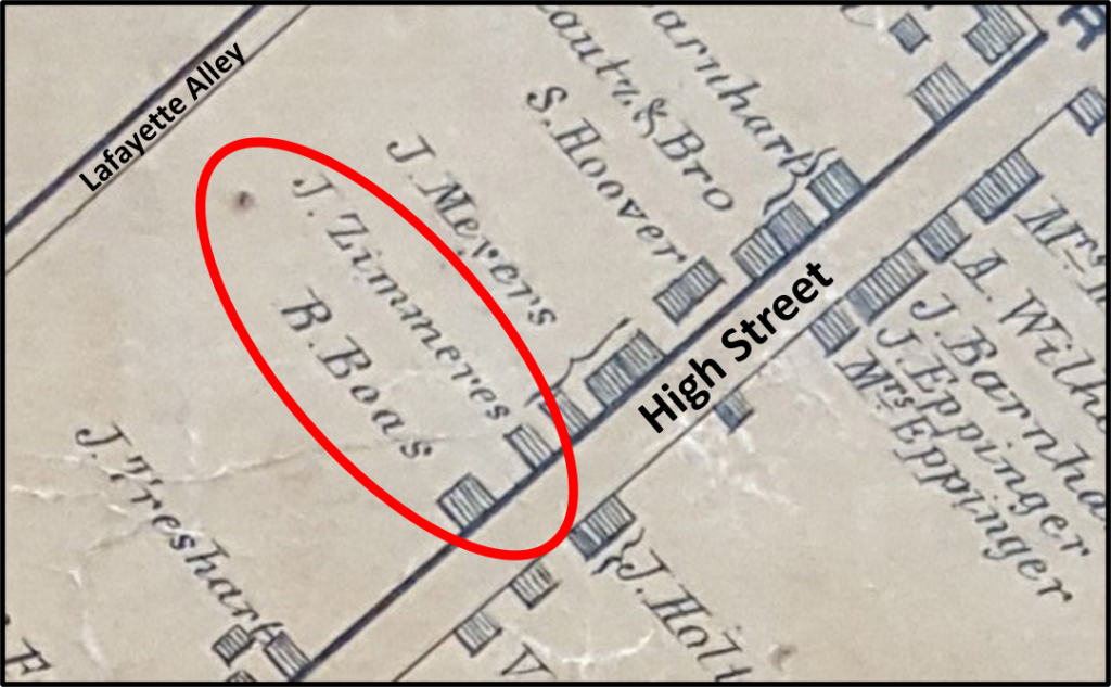
Map of part of the 400 block of High Street in 1850, showing the one-story houses at 433 (owned by John Zimmerer) and 435 (owned by Robert Boas). From Moody and Bridgens.
Liphart
rented the houses out for a short while, and then split the 62-foot-wide lot in
half, with the northeast half containing the one-story log house now numbered
433 High, and the southwest half containing the one-story frame house now
numbered 435 High. In 1844, Liphart sold the half with 433 to John Zimmerer, a
middle-aged tailor and his wife Sarah. Earlier, in 1842, Liphart had sold the
half with 435 to Robert Boas, a middle-aged laborer, his wife Franciska, and
their young son. Both Zimmerer and Boas were German immigrants, and both
families lived in the houses they had bought, each of which was valued at $220
in 1845.
Part of 1857 deed (Book I, Volume 14, Page 478) with mention of the log house at what is now 433 High.
John
Zimmerer died in 1857, and his wife Sarah sold the log house at 433 to Jacob
and Susan Glassbrenner for $300. The Glassbrenner family lived in the house for
a few years and then rented it out to tenants. After Jacob died, his widow
Susan, who had moved to Philadelphia, sold the house to William Lebkicher in
1906.
Robert and
Franciska Boas lived in the frame house at 435 High for many years. Sometime in
the 1860s, they added the two-story brick house next door at 437 High,
squeezing it into the remaining part of their lot. Boas and his wife moved into
the larger 437 and rented 435 out to tenants until Boas’s death. In 1881, the
frame house at 435 High and its larger brick companion at 437 were sold as part
of Boas’s estate for $1,000 to John Kirsch. In 1920, after Kirsch had died, the
courts granted the property to his widow Barbara at a value of $500 as part of
her widow’s exemption.
Map of part of the 400 block of High Street in 1897, showing the one-story log house at 433 High and the one-story frame house at 435 High, as well as the two-story brick house at 437 High that was added next to 435 in the 1860s. From Sanborn Fire Insurance Map.
Today, Peter
Bier III would have difficulty recognizing his houses. The one-story log house
at 433 High is covered with vinyl siding, and the one-story frame house at 435
High is sheathed in gray form-stone. Both houses have had their original doors,
windows, and roofs replaced. Dormers have been replaced or enlarged, and
concrete steps now lead up to the front doors. But behind all the modern
features, more than 200 years of history lie hidden.
It is my
belief that 433 and 435 High Street are the only two houses that survive from
the original 25-30 houses built in old Bethelstown between 1762 and 1815. Since
Bethelstown preceded the development of the rest of the Hill, these two houses
also are the oldest surviving houses on all of Cabbage Hill.
Sometimes a little historical sleuthing can uncover some remarkable stories hiding just behind modern siding and form-stone on the old houses on the Hill.
A quiz for
Cabbage Hill residents: Which of the following five street names were actual
street names on Cabbage Hill in the nineteenth century? (1) Buttonwood Alley,
(2) Roberts Street, (3) West Washington Street, (4) Williams Lane, and (5) Slab
Alley.
The answer
to the quiz: All five were actual street names on the Hill. OK, maybe the
question is a little unfair, even for old-timers. You would have to be well
over 100 years old to have any in-person
memory of some of the street names in the quiz.
The point is
that the names of many of the streets on the Hill have changed over the past
200 years. Specifically, there are 12 main streets in the historic core of
Cabbage Hill, which is bounded by Manor, West Strawberry, Fremont, and Fairview.
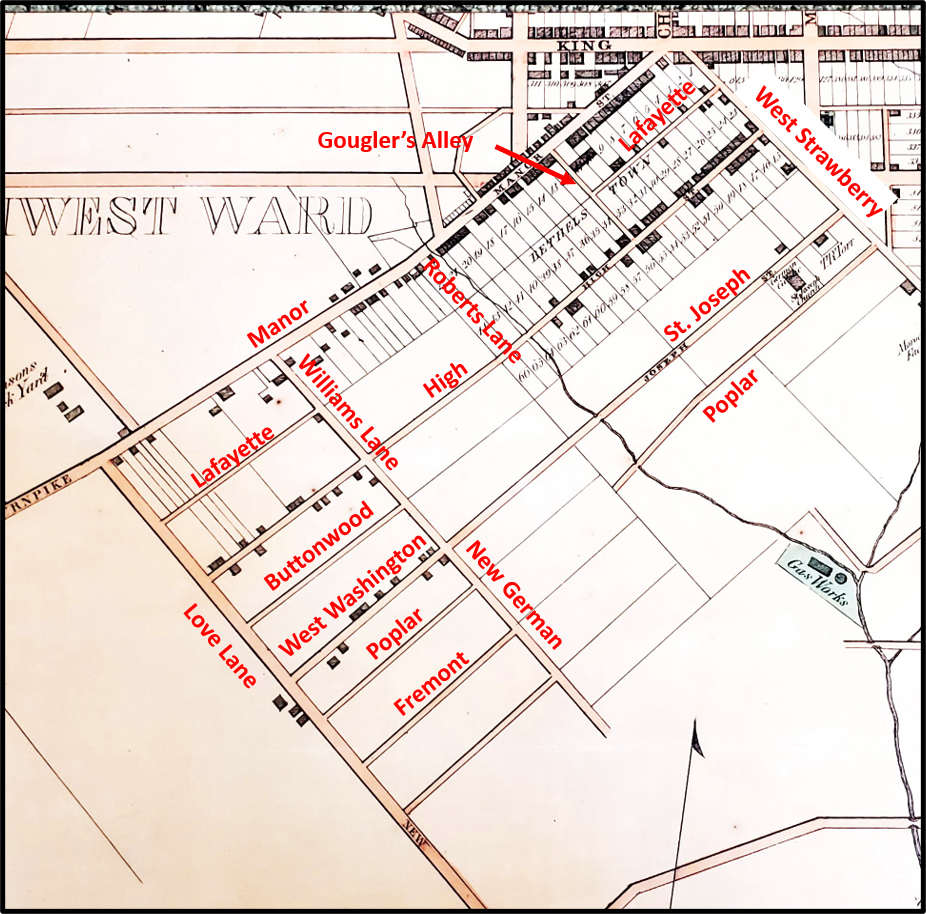
Those 12 streets have had more than 30 different names.
Streets on Cabbage Hill in the mid to late 1850s, shown on an 1858 map. From T.J. Kennedy’s Map of Lancaster.
Manor
Street, the oldest street on the Hill, was already a well-traveled Native
American trading trail when Lancaster was founded in 1729. It was known as the
Blue Rock Road in the mid to late 1700s, because it led to an early ferry
across the Susquehanna at Blue Rock just south of Washington Boro. In the early
1800s, the southwestern stretch of the street was often called the Manor
Turnpike, because of the toll levied on travelers as they crossed the
southwestern city limits. Finally, in the mid-1800s, the street became known as
Manor Street.
West
Strawberry Street is the second oldest street on the Hill, having been a dirt cowpath
that marked the southwest edge of central Lancaster when James Hamilton laid
out his building lots in 1729. It was known as Slab Alley as late as the 1840s
and then in the early 1850s, it became West Strawberry, to distinguish it from
its continuation known as East Strawberry on the other side of South Queen
Street.
On the opposite
end of the historic core of the Hill, Fairview Avenue has been around a long
time as a connecting road to South Prince and South Queen at Engleside. From
the mid-1800s to 1915, it was called Love Lane, and it has been Fairview Avenue
since then. The change of name to Fairview makes sense because it runs along a
ridge from which expansive views were possible. I can find no explanation for
its first, more amorous, name.
High Street
originated with the founding of Bethelstown in 1762 when building lots were
laid out on either side of its first two blocks (400 and 500 blocks). By the
1850s, High had been extended southwest to Love Lane, bridging the small stream
at the bottom of the hill where New Dorwart is today. Presumably it was called
High because of the location of the 400 block on a high point known as Dinah’s
Hill.
St. Joseph
Street has a complicated naming history. The 400 block of St. Joseph was
established in 1850 when St. Joseph Catholic Church was built. At the time the
church was built, the street it fronted was called Union Street (not to be
confused with today’s Union a few blocks to the southeast, which didn’t exist
yet). Then, in the early 1850s, just to make things even more confusing, the
street was sometimes referred to as Poplar Street (before today’s Poplar a
block over was established). Finally, by the end of the 1850s, the 400 and 500
blocks were renamed St. Joseph. However, at that time, St. Joseph did not
extend beyond what is now New Dorwart, and in the meantime the 700 block
between Fairview and Laurel had been laid out, and the street there was known
as West Washington Street. In the late 1850s, when the two streets were
connected by the building of a bridge over the small stream at the future New
Dorwart, the entire street became known as St. Joseph.
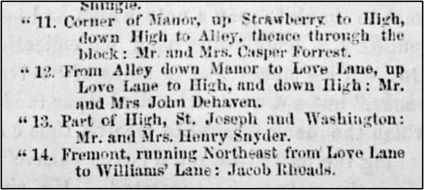
Part of an article establishing Block Committees in the Southwest Ward, in which the early names of some streets are referred to; from the Daily Evening Express, December 15, 1857.
Now that
we’ve brought up Poplar Street……When St. Joseph Church was built in 1850, the
small alley behind the church with no houses on it had no name. In the late
1850s, it became Poplar and it was extended to the stream at the bottom of the
hill at about the same time the future 700 block of Poplar was laid out on the
far side of the stream. In 1870, building lots were laid out on the east side
of the 400 block of Poplar. A year later, on the other side of the stream, the
700 block was named Poplar Alley. In the late 1870s, the street was connected
with a bridge over the stream, and the whole street was named Poplar Street.
Moving
farther east, Fremont Street was established in the late 1850s, starting with
the 700 block between Fairview and Laurel. In 1870, when the building lots were
laid out along the 400 block of Poplar, so too were building lots on both sides
of the 400 block of Fremont. In the early 1870s, the two ends of Fremont were
connected by completing the street in between them. Like Love Lane, I don’t know
the origin of the name of Fremont Street, although when the street was first
laid out in the 1850s, John C. Fremont was a popular national personality who
had been an explorer of the West and then the Republican opponent of James
Buchanan in the 1856 presidential election.
Now heading back
to the west……West Vine Street started as a narrow alley behind the
Bethelstown lots that fronted on the southeast side of High in 1762. The first
inkling of the street that would become West Vine was born between Fairview and
Laurel, where Buttonwood Alley was established in the late 1850s. When the
blocks to the northwest up to West Strawberry were established by the 1880s,
they were called Buttonwood Street. Buttonwood was renamed West Vine in 1890 as
the southwestern continuation of the older West Vine on the other side of West
Strawberry.
Next, to a
street that cuts across the Hill from the northwest to the southeast—Laurel
Street. It was first named in the early 1850s when it was a private lane
providing access to the 25-acre property of John Williams between Manor and St.
Joseph, and naturally enough it was called Williams Lane. In the 1860s, it was briefly
known as New German Street, and then just New Street, and by about 1870, it
became known as Laurel Alley, possibly named for local vegetation. From about 1885
to today, it has been Laurel Street.
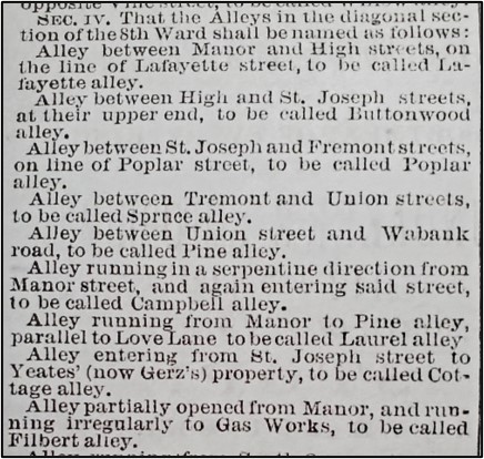
Part of an article describing the city’s plan for naming alleys in the 8th Ward; from the Intelligencer Journal, November 21, 1871.
Another
northwest-southeast street is Filbert Street. From the establishment of
Bethelstown in 1762, there had always been an alley where the first block of
Filbert is now. In the late 1850s to early 1860s, it was known locally as
Gougler’s Alley, so named because of the house of Jacob and Rebecca Gougler at
its intersection with Manor. But it wasn’t until 1871, when the city named or
renamed all its alleys, that it became Filbert Alley. About 1890, Filbert Alley
was promoted to Filbert Street. Because of irregular property boundaries near
the old St. Joseph Cemetery, Filbert had to be offset slightly at St. Joseph
Street.
Another
alley that eventually grew up to be a street is Lafayette Street. In old
Bethelstown, the lots on the southeast side of Manor extended back to meet the
lots on the northwest side of High. They met at a narrow alley that would
eventually become Lafayette Alley. In the late 1850s, houses had started to be
built fronting the alley and the 400 block of the alley was widened to become
Lafayette Street. At the same time, the 700 block of Lafayette was established,
with a gap in the street where the 500 and 600 blocks would soon be. By about
1890, the two developed ends of the street met in the middle, making one
continuous Lafayette Street. The street may have been named for the Lafayette Hotel,
which existed on Manor in the 1840s and 1850s, and backed to the alley that
would become Lafayette.
All the
streets that run from West Strawberry to Fairview had to contend with the small
stream that used to run where New Dorwart is today. For most of those streets,
the last segments to be built (the 500 and 600 blocks) were the ones nearest
the stream. In the 1860s, it appears that a rough path that ran along the
stream valley was known as Roberts Lane, likely named for Anthony Roberts who
owned land nearby. In the 1880s, the city placed a 6-foot-high brick sewer
under the stream, diverted the stream into it, and built New Dorwart on top of
it. New Dorwart was first named South Dorwart, a name that faded gradually over
time and was finally replaced with New Dorwart about the 1920s. New Dorwart had
to be offset at Lafayette, and again at High, because of bends in the
now-vanished stream around which early houses had to be built.
Now, if your
eyes have not yet completely glazed over with all these street names………In honor
of this month’s Valentine’s Day, if anybody has any ideas on why Fairview
Avenue was originally called Love Lane, please comment with your ideas!
Cabbage Hill
once had its very own volunteer fire company. From 1838 to 1882, it served the
West King and Manor Street corridors. Starting very humbly as the Humane Hose
Company, it fought many fires and was a source of much neighborhood pride.
The Humane
Hose Company was established in 1838 by a group of civic-minded citizens of the
west and southwest sections of Lancaster. In August of that year, they
purchased a hose carriage from a company in Philadelphia and paraded it through
the streets of Lancaster, with the “uniform of the members neat and
appropriate” and its members “entitled to much credit for their zeal and public
spirit.”
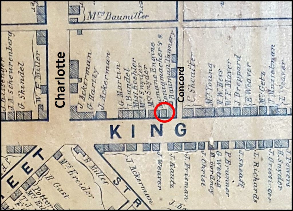
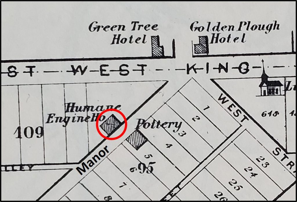
First location of Humane Hose Company on the north side of West King, just west of Concord Alley. From Moody and Bridgens, 1850.
In March
1839, the charter of the Humane Hose Company was approved, limiting the company
to 40 subscribing members and establishing its hierarchy of officers and
directors. The company rented part of a lot on the north side of West King just
above Concord, and built a small frame building in which to keep its hose
carriage.
In the early
1840s, a few of Lancaster’s more established fire companies had their own
horse-drawn, hand-pumper engines, but the Humane only had a hose carriage,
which was simply a large reel holding a wound-up hose on a four-wheeled
carriage. The members of the Humane would pull the carriage to the scene of a fire
using ropes, unwind the hose and hook it to one of the city’s new fire plugs, and
use the hose to fill the tanks of the hand-pumpers of the other companies.
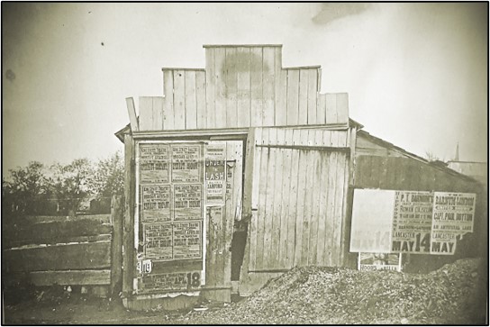
Remains of the first house of Humane Hose Company on West King. Photo taken in early 1880s by George M. Steinman, Humane treasurer, some 30 years after the Humane had moved from the site, and just before the building was torn down in the mid-1880s.
In June
1853, for $225, the Humane purchased the rear portion of a lot on West King to
be the site of their new larger hose house. The Humane’s lot fronted 21 feet on
the northwest side of Manor and extended 30 feet in depth. The Humane built a
two-story brick hose house on the site, approximately where the rear parking
lot for Reveron Electronic, Inc. is today, across from 424 Manor. The hose
house was topped with a bell tower from which fire calls would ring out.
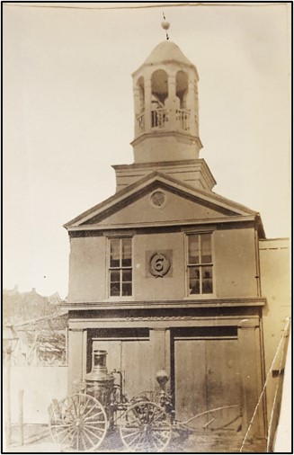
Location of Humane Steam Fire Engine Company No. 6 on Manor Street. From Everts and Stewart, 1875.
At the time
the Humane’s new hose house was built, the company boasted 75 active members.
Only six were property owners; the others were minors or those “who earn their
bread by hard labor”. Their hose carriage had become old and was in need of
repair, eight sections of hose were deemed too old to function dependably, and
the company was $550 in debt. Other volunteer companies also were struggling
with hose problems, and in 1854, the city allocated $3,000 to be shared among the
Humane and four other companies for the purchase of new hoses.
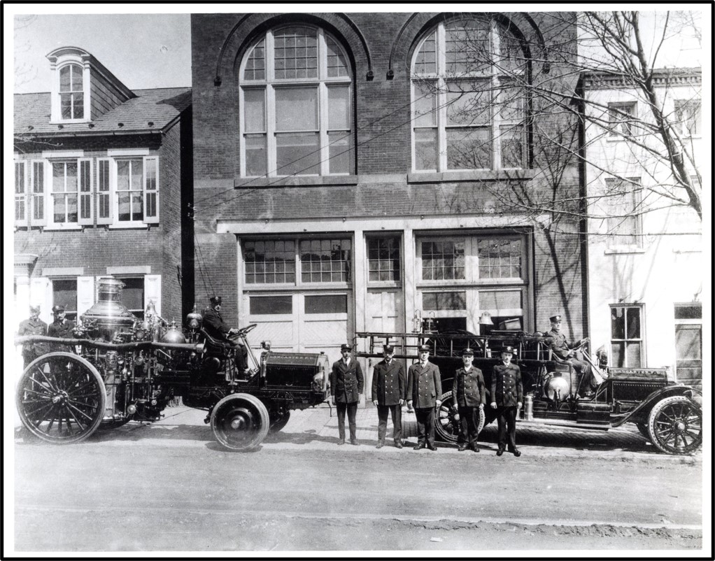
Humane Steam Fire Engine Company No. 6 on Manor Street, about where the rear parking lot of Reveron Electronic, Inc. is today, across from 424 Manor. This house was built in 1853, and was the home of the company for about 25 years. Note the steam-pumper fire engine proudly displayed in front of building. The Humane bought their steam-pumper in 1867, so this photo was likely taken shortly after then. Photo from collection of George M. Steinman, treasurer of the company.
By 1857, the
Humane’s situation had improved to the point that it was able to purchase its
first engine—a used hand-pumper purchased from the Union Fire Company for $300.
The hand-pumper engine was a metal tank mounted on a horse-drawn, four-wheeled
carriage. In the tank, which was filled with water, was a set of pistons that
were operated by long horizontal levers called brakes extending from either
side of the carriage. Teams of men moved the brakes up and down in rapid
succession to activate the pistons, drawing water in from a hose connected to a
water source with one stroke, and then driving the water out under pressure
through a hose leading to the site of the fire with the next stroke.
The Civil
War had a major impact on the Humane. The call for soldiers drew on the same
pool of young men who were active in the Humane. In early September 1862, about
10 days before the Battle of Sharpsburg (Antietam), the Governor of
Pennsylvania asked for all able-bodied men to start military drills in their
neighborhoods, as the Confederate Army was moving north to invade the state. As
a result, a large number of men from the “Hill” met at the Humane’s hose house
to get organized. One of the speakers noted that 69 of the Humane’s volunteers
had become soldiers and that only 18-20 volunteers were still available locally
to fight fires.
By the
mid-1860s, the Humane decided that it should have a steam-pumper like the one
the Union Fire Company had recently acquired. A steam-pumper consisted of a
steam boiler mounted on a horse-drawn, four-wheel carriage. The steam boiler
was used to pressurize the water, forcing a stream of water through a hose
directed at a fire. In 1866, the members of the Humane began canvassing the
neighborhood for subscriptions to buy a new steam-pumper.
In early
January 1867, after enough money had been pledged, a committee was appointed to
purchase a steam-pumper. The committee went to Philadelphia to purchase the new
apparatus, and a couple weeks later the new steam-pumper was delivered to
Lancaster. The steamer was purchased for $2,800 from the Undine Steam Fire
Company of Holland, New York, and had been built by A.B. Taylor.
On a cold January
day, a parade was held to deliver the new steamer to the Humane’s house on
Manor. Six Lancaster fire companies were represented, in addition to 75 men
from the Humane. After the parade was over, the men of the Humane were anxious
to see their new engine perform, so they took it back down to the square, where
they fired it up and threw a stream of water 200 feet up North Queen.
In the early
1870s, the Humane is said to have declined in membership, and was saved from
folding only by a reorganization in late 1875. Hugh Fulton was elected
President, and the company officially modified its charter in April 1876,
taking on the unwieldy new name of the Humane Steam Fire Engine and Forcing-Hose
Company No. 6.
Lancaster City Fire Department Station House No. 1 in 1918. This house was completed in 1880 as the engine house of the Humane Steam Fire Engine and Forcing-Hose Company No. 6. The building is now occupied by Station One Center for the Arts. Photo courtesy of Ryan Conklin, Lancaster City Fire Department.
The
revitalized Humane decided to move out of its aging house on Manor. A lot was
purchased for $2,100 not far away on the north side of the 400 block of West
King, and the foundation for a new larger building was laid there in 1878. The
new engine house cost almost $5,300, and was completed in 1880. It still stands
at 411 West King and is currently occupied by Station One Center for the Arts.
The grand
opening of the new West King engine house in October 1880 was marked by a ball
attended by 150 couples. The ball was held in the large second-floor room of
the new house, which measured 40 by 100 feet. The newly energized version of
the Humane seemed to be on its way, but within about two years, it went out of
business when Lancaster City decided to take over the firefighting services
that had heretofore been handled by the numerous volunteer companies.
In April
1882, the new city fire department was established, and in June 1883, the city
purchased the Humane’s three-year-old house on West King for $5,200. The city
designated the house on West King as its Station House No. 1, which would
remain in use for many decades.
The Humane
Hose Company on Manor is now a forgotten ghost of old Cabbage Hill, but in its
time it was a formidable firefighting organization that helped protect the
Hill’s buildings for some 40 years, as well as an important part of the Hill’s
social scene.
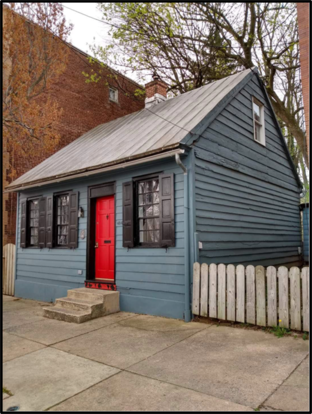
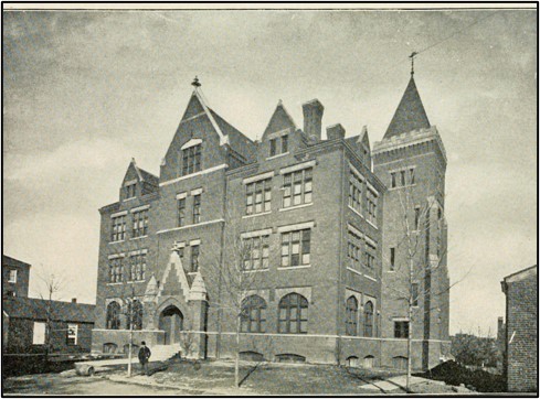
One of the better-preserved
one-story houses in Lancaster is the blue house with the red door at 434 West
King Street. This four-bay, center-chimney, Germanic-style house is typical of
the many hundreds of such houses, also sometimes known as one-and-a-half-story
houses, that once dominated the architecture of the city during the Federal
period of the late eighteenth and early nineteenth centuries. The 550-square-foot
house is located on the very northern edge of the SoWe project area, less than
a block outside of Cabbage Hill.
434 West King Street. Photo courtesy of its current owner, David Aviles Morales.
How old is
the house? Who built it? Who owned it over the years? There is not much
information available to answer these questions, and what little exists is somewhat
contradictory. Real-estate websites date the house as early as the 1790s and as
late as 1880. A 1985 survey by the Historic Preservation Trust and a 1995
report by the City of Lancaster both refer to the property as the Geise House
and date it to about 1840. But an old map and tax records show that a Barbara Geiss
owned the house next door instead. To try to resolve these conflicts and answer
the questions above, extensive research into historic deed, tax, directory,
newspaper, and other sources was undertaken.
The result
of that research indicates that 434 West King has an interesting and fairly
complicated history. Construction of this venerable old one-story frame house probably
was completed in 1817. The lot where the house is located was originally 64
feet wide along the south side of West King and 245 feet deep to what would
eventually become Campbell Alley. The house’s early history is closely tied to
the Eberman family, a prominent family in Lancaster in the late 1700s.
John Eberman
III (1776-1846) probably began building the house at 434 in late 1816. John III,
a cashier and bank treasurer, was the son of John Eberman, Jr. (1749-1835), a
famous clockmaker whose clocks are highly valued today. John, Jr. also was a
prominent Lancaster citizen who served as Chief Burgess and Justice of the
Peace, and as a sergeant in the Revolutionary War. John, Jr. made and installed
the four-dial clock in the steeple of the second courthouse in the square about
1785. John, Jr.’s father, John Eberman, Sr. (1722-1805), was a soap boiler and
tallow chandler who immigrated to Lancaster from Germany in the mid-1740s. The
Ebermans were a prolific family: John, Sr. had 12 children, John, Jr. 13, and
John III 10.
Part of the Lancaster County tax list for Lancaster Borough for 1817, the first year that 434 West King was on the tax rolls. Note that John Eberman, the owner, had taken in “P. Sugar’s” as a tenant in his “unfinished” house. The four numbers at the end of the entry denote 1 house, 1 lot, 63 shillings ground rent, and $250 assessed value.
Several
members of the extended Eberman family owned 434 from 1816 to 1838. Before John
III had even completed the house, his first tenant moved in. Tax records show
that John III rented the house “unfinished to P. Shugar’s” in 1817. (Presumably
John III and/or Shugar completed the house shortly thereafter.) Peter Shugar
was related to John III through marriage; he had married John III’s aunt,
Elizabeth Eberman, in 1796. Upon marrying into the Eberman family, Shugar took
over the aging John, Sr.’s soap and chandler business. The Shugars had six
children.
Unfortunately,
Peter Shugar, whose surname was later anglicized to Schucker, died a couple
years after moving into 434. Immediately after Peter’s death, his wife
Elizabeth bought the house, which was valued at $250, from her nephew, John
III. A few years later, in 1823 or 1824, Elizabeth divided the lot into two,
keeping 434 on the western half of the lot for herself and selling the vacant eastern
half of the lot back to her nephew, John III. By 1829, John III had built a
one-story frame house on the eastern half of the lot, the house number for
which would eventually be 430. (This house, which had a brick front and was a
little larger than 434, was torn down around 1900 and replaced with the three-story
building that now stands to the east of 434.)
In 1830 or
1831, the ownership of 434 became more complicated. Elizabeth Shugar sold the
house to Jacob Eberman, a shoemaker who was Elizabeth’s nephew, the son of her
older brother Philip. Jacob was also Elizabeth’s son-in-law. He had married his
first cousin, Peter and Elizabeth’s daughter Sarah Shugar, in 1824. Jacob’s
ownership of 434 did not last very long. By 1832, Jacob and Sarah and their
children had moved to Wooster, Ohio, selling 434 to Jacob’s cousin William
Eberman, the son of John, Jr., the clockmaker, and the younger brother of John
III. (Jacob and Sarah would return to Lancaster about a year later, and live in
a one-story house on West King across from 434.) William Eberman, who bought
434 from Jacob, was a tinsmith and an innkeeper. William also bought the house
at 430 at the same time.
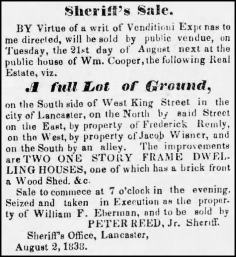
Advertisement in the Lancaster Examiner, August 16, 1838, describing the public sale of William Eberman’s two houses, one of which was the house at 434 West King.
William
Eberman owned 434 and 430 until 1838 when he apparently ran into financial
trouble and was forced to sell the two houses to pay off his debts. Dr. Charles
Herbst, a pharmacist, bought both houses at a public sale in September 1838. In
a newspaper advertisement for the sale, the houses were described as “two one
story frame dwelling houses, one of which has a brick front a wood shed etc.”
on a “full lot of ground on the south side of West King Street.”
Charles
Herbst sold both houses on April 1, 1840. The house at 430 was sold to Barbara
Geiss, a widow with a young son, for $475. The house at 434 was sold for $425
to Margaret Gantz, a widow who had two children. At about the same time widow
Gantz bought 434, she remarried, to Joseph Kunkle. Joseph Kunkle was a peddler,
and he and Margaret had four more children together over the next decade.
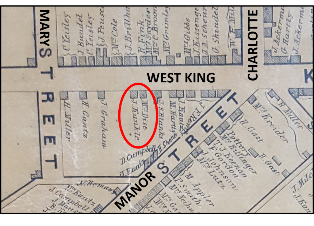
1850 map showing the house at 434 West King and its owner J. (Joseph) Kunkle. Also shown is the house next door at 430 West King and its owner Mrs. (Barbara) Geiss (misspelled Dise). From Moody and Bridgens.
Joseph Kunkle
died in the mid-1860s. His wife Margaret continued living in 434 until her
death in 1890. Margaret’s will stipulated that her daughters Mary and Rose were
to continue to live in 434 as long as they wished. The two sisters lived there
following Margaret’s death for five years until Rose came down from the attic
level one day to discover her sister Mary dead in the summer kitchen.
Rose Kunkle continued
living in 434 until she married Leo Myers in 1909 and moved with him to St.
Joseph Street, where Leo ran a grocery store. (Leo Myers’ grocery was located
in the recently-painted light green house on the corner of Filbert and St.
Joseph Streets, with “Welcome to Cabbage Hill” painted on its side.) When Leo
died in 1913, Rose moved back to 434, living there alone until her death in
1929.
After Rose’s
death, the administrator for Margaret Kunkle’s estate sold the house at public
sale to Sarah and Jack Winkoff, who paid $4,380 for the house and half lot. An
advertisement for the public sale stated that the “Lot fronts 33 feet on the
south side of West King street…” and “The improvements consist of a 1 ½ story
frame house, with six rooms.”
The Minkoffs
rented out 434 until 1965, when they sold it to Ronald Cook, who lived there
until 1973, when he sold it to Carol Miller, who lived there into the 1980s. The
current owner is David Aviles Morales, who has maintained it without changing
its basic historical appearance. The house is now available for booking as an
Airbnb rental.
So, to
answer the earlier questions: 434 West King was built about 1817 by John
Eberman III. For a 203-year-old house, it has not had very many owners, with
the Eberman, Kunkle, and Minkoff families accounting for nearly 150 of those years.
A good name for the house might be the Eberman-Kunkle House, in honor of its
builder and the family that owned it the longest.
As a
survivor from an earlier time in Lancaster’s history, 434 West King reminds us
of what much of Lancaster used to look like. Hopefully, it will continue to
have owners dedicated to its preservation, and serve as a reminder of our
history for many years to come.
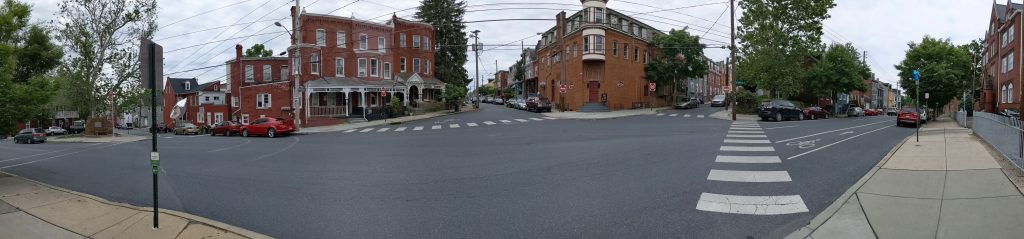
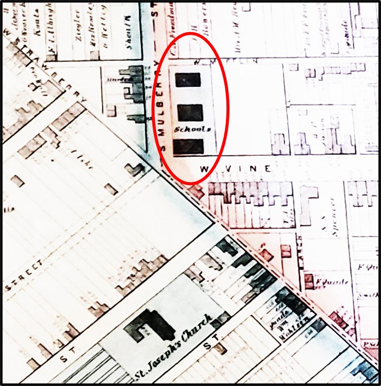
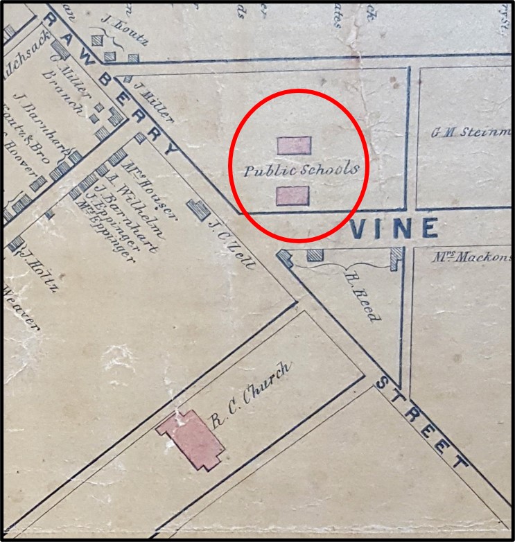
The
five-point intersection of West Strawberry, South Mulberry, and West Vine
Streets, which is the gateway to Cabbage Hill from downtown Lancaster, has
witnessed a lot of history. On the northeast corner of the intersection,
bounded by South Mulberry and West Vine, a large school building now stands on
a lot where 170 years ago some of the very first schools of Lancaster’s
public-education system once stood. Let’s peel back the layers of school history
at this site, starting with the first layer (today) and working back to 1850,
with the emphasis on the fourth (earliest) layer, about which less is commonly
known.
Layer 1,
1992-2020–The first
and most recent layer of school history at this intersection covers 1992 to the
present. Housed in the large Victorian-era brick building on the northeast
corner of the intersection is the Intensive Day Treatment Program run by
Catholic Charities of the Harrisburg Diocese. The program offers a
five-day-a-week program of counseling, therapy, and life-skill education for
at-risk Lancaster County children between the ages of nine and fifteen.
The Victorian-era school building on the northeast corner of South Mulberry and West Vine. Photo taken in 2020.
Layer 2,
1939-1992–The second
layer of school history, just beneath today’s surface layer, covers 1939 to 1992.
Many long-time residents of Cabbage Hill will remember this layer, when the
current large brick building was the home of St. Joseph Catholic School. The
Harrisburg Diocese bought the building on behalf of St. Joseph Catholic Church
on July 10, 1939, and established a parochial school for the education of
Catholic children on the Hill. The diocese purchased the building from the
Lancaster City School District for $22,500 and renovated it to meet St. Joseph
Church’s needs. The purchase was made to ease the crowding of the school located
next to St. Joseph Church a block away. Many Cabbage Hill children received
their primary-school education at St. Joseph School.
Layer 3,
1892-1939–Peeling
back the second layer of school history, we expose the older third layer, which
covers 1892 to 1939. No doubt there are a few old-timers who remember at least
the later years of this layer, which begins with the completion of the current
large brick school by the School District of Lancaster in 1892, and ends when
the building was sold to the Harrisburg Diocese in 1939. The building currently
at the site, then known as the South Mulberry Street School, was part of the
City of Lancaster’s public-school system for nearly fifty years, and served as
both a primary and secondary school. It was built to accommodate the growing
numbers of students that resulted from increased immigration to the Cabbage
Hill area in the late nineteenth century.
The
architect who designed the South Mulberry Street School (1892) was James H.
Warner, who also designed several other prominent buildings in Lancaster at
about the same time, including Central Market (1889) and Christ Lutheran Church
(1892). It is not surprising that the exterior of the South Mulberry Street
School bears a strong resemblance to the exteriors of these other two buildings,
in that all three are built in similar Victorian style with red brick
highlighted by decorative brownstone accents.
Also built
about the same time and in similar style was the three-story Victorian-era
brick building on the corner across West Strawberry that until recently housed
the Strawberry Hill Restaurant, and was originally the Centennial Hotel. In
addition, the grouping of three three-story brick houses diagonally across the
intersection, and directly facing the intersection on the south corner, was
built in the 1890s. The late Victorian makeover of the intersection was
complete by the late 1890s.
Layer 4,
1850-1892–Finally, way
down in the layers of school history at this site is the fourth and earliest
layer. It begins in 1850 and ends in 1892, when the large school building now
on the site was completed. To clear the ground for the large current building,
the School District of Lancaster razed two older school buildings built in 1850
and a third school building built in the late 1860s. All three of the earlier
buildings were one-story brick buildings, with the third building being
slightly larger than the first two.
Map showing the three school houses in 1874. The third, slightly larger, school house had just recently been built. Note that West Strawberry was still a narrow lane, and the southern West Vine extension was just being laid out. From Roe and Colby, Map of the City of Lancaster, 1874.
The first
two of these early school buildings were among the very first public-school
buildings built in Lancaster following the implementation of the city’s common
(public) school system in the early 1840s. The first two buildings—essentially
double one-story brick houses—were built in 1850. They were built on Hamilton
lot 386, one of the original building lots laid out by James Hamilton in 1730.
Lot 386 had been purchased by the Board of Directors of the Common Schools from
Margaret and Catharine Yeates, daughters of Judge Jasper Yeates, on June 26,
1849, for $300. The lot was 64 feet on West Vine, extending 242 feet to
Mifflin.
Map showing the first two one-story brick school houses on the north side of West Vine in 1850. Mulberry had not yet been extended south past West Orange, and West Vine had not yet been extended across West Strawberry. St. Joseph Catholic Church had just been built. From Moody and Bridgens, Map of the City of Lancaster, 1850.
At the time
the Board of Directors purchased lot 386 and built the first two school houses,
South Mulberry did not yet exist; Mulberry’s southern extent ended at West
Orange. As a result, the two school houses were referred to as the West Vine
Street School until Mulberry was extended in the mid-1850s. Also, when the
school houses were first built, West Vine did not exist south of West
Strawberry. Therefore, today’s distinctive five-point intersection was only a
three-point T-intersection with the north part of West Vine truncating at West
Strawberry, which was still a narrow dirt lane. In addition, in 1850, the
foundation of the first St. Joseph Catholic Church was just being dug, and today’s
Christ Lutheran Church was still several decades in the future.
Lot 386 was
near the top of Dinah’s Hill and it looked out on downtown Lancaster to the
north and was bounded on the south, in 1850, by pasture land of the still undeveloped
central part of Cabbage Hill. Across West Strawberry to the south was Christopher
Zell’s one-story frame blacksmith shop that would soon be enlarged into the
Centennial Hotel and Saloon. There were only a few other buildings within a
block of the two school houses, including the small log cabin across West Vine
where 113-year-old ex-slave and fortune-teller Dinah McIntire had lived several
decades before, giving her name to the hill on which lot 386 was located.
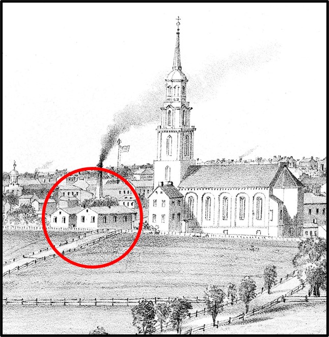
Enlargement of an 1852 lithograph showing the first St. Joseph Catholic Church and the first two school houses on West Vine. The flattened perspective makes it seem that the school houses are across the street from the church, but they were actually a half block past the church across West Strawberry. Drawing by Charles R. Parsons.
When the
first two small school buildings opened in 1850, they served both primary- and
secondary-age children, mostly of German heritage. It didn’t take long for the
two school buildings to become crowded as Cabbage Hill began to grow.
Anticipating and reacting to that growth, the Lancaster School District acquired
two more pieces of land adjacent to lot 386—a 16-foot strip of land between lot
386 and the recently extended South Mulberry to the west in 1860, and a 24-foot
strip of land on the east side of lot 386 in 1878. Both strips of land extended
to Mifflin.
The third
school building was added to the south of the first two in the late 1860s to
serve as a primary school for both boys and girls. It was a little larger and
sat a little closer to South Mulberry, taking advantage of the strip of land added
in 1860. By the late 1880s, the three small school houses were again becoming
crowded as well as outdated, prompting the School District to plan for their
replacement by a larger, more modern building—the one that is on the site
today.
It would, of
course, be historically interesting to have a photograph of the three early
public-school buildings before they were torn down in the early 1890s, but it
seems there are none devoted to just the three buildings themselves. However,
partial images of the first school houses on the site were inadvertently
captured in the corners of two other photographs before the early school houses
were forever lost to history.
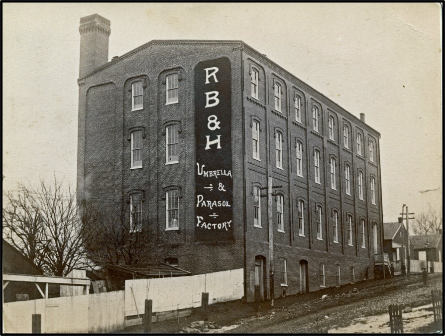
Photograph of Rose Bros. & Hartman Parasol & Umbrella Factory on South Mulberry in the late 1880s. The factory is now the rear one-third of the Umbrella Works Apartments. From LancasterHistory photo archive, no. A-13-01-28.
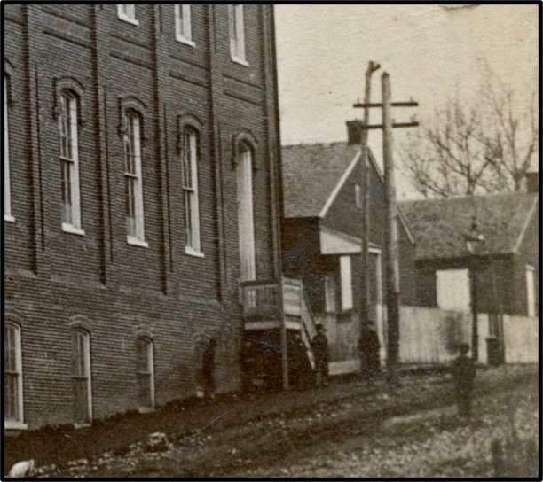
Enlargement of the lower right corner of the photograph to the left, showing the two one-story brick school houses (built in 1850), prior to them being torn down.
First, in
the late 1880s, a few years before the current building was built, a
photographer from the Fowler Gallery took a picture of the Rose Bros. &
Hartman Parasol & Umbrella Factory in the first block of South Mulberry.
This factory would soon be expanded down to West King and become the Follmer, Clogg
& Company umbrella factory, and today the Umbrella Works Apartments. On the
right edge of the photograph one can see the fronts of the first two small,
one-story, brick school houses built in 1850.
South Mulberry Street School, at the completion of construction in 1892. Note the old one-story brick school house, built in 1850, on the left edge of the photograph, and the old one-story brick school house, built in the late 1860s, on the right edge. Photo from Riddle, 1905.
Then, in
1892, when the current larger building had just been finished, a photograph was
taken to commemorate its completion. On the left edge of the photograph can be
seen the side of one of the first school houses built in 1850, and on the right
can be seen the front edge of the third school house built in the late 1860s.
It seems that only the middle school house had to be torn down to build the new
larger school, and the other two were used for classes while the new larger
school was being built. Then, when the new school opened, the remaining two old
school houses were torn down.
One can
learn a lot about the evolution of schools at this iconic five-point
intersection just by using historical records and photographs to peel back the
layers of history.
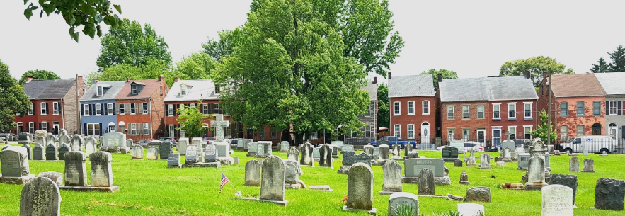
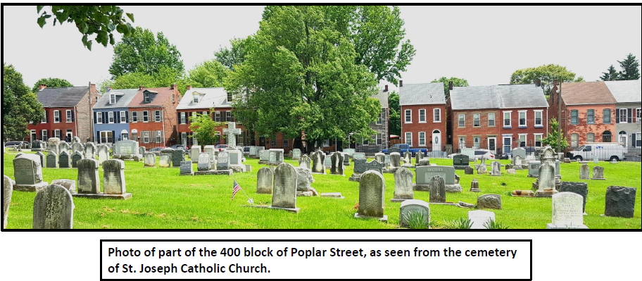
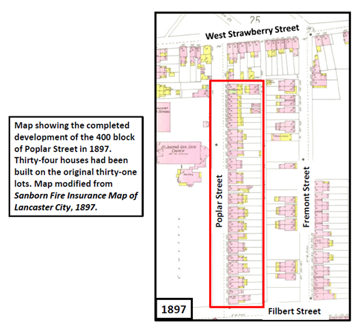
The 400 block of Poplar Street, one of the most picturesque blocks on Cabbage Hill, dates back to October 5, 1872. On that date, at 2:00 p.m., a public sale of building lots was held as part of the estate settlement of Henry C. Locher, the developer of the lots, who had died the previous year.
First, by way of a little background…..In 1872, the central part of Cabbage Hill was in the midst of a development boom, spreading from Manor Street eastward. In the west, the 400 and 500 blocks of Manor and High Streets in the Bethelstown neighborhood were almost completely built up, with the former Lafayette and Buttonwood (West Vine) Alleys beginning to be built on as well. Moving east, the 400 and 500 blocks of St. Joseph Street had acquired houses on about half of their lots. But on Poplar Street, although St. Joseph Catholic Church was on the northwest side, the southeast side of the 400 block was devoid of houses. With the October 1872 sale of Henry C. Locher’s lots, that was about to change.
Thirty-one lots on the southeast side of Poplar had been staked out by Locher and his family in early 1870. All but two of the lots were 20 feet wide by 100 feet deep; the exceptions were the two end lots that were a little wider at 30 and 27 feet. All the lots backed to an alley that would eventually become South Arch Street. The lots were numbered from 7 to 37. Bidders on the lots could bid on single lots or as many as three contiguous lots.
The sale took place across Poplar from the rear of St. Joseph Catholic Church and the adjoining cemetery, which had been established less than 25 years earlier. According to an announcement of the sale in the Lancaster Examiner and Herald: “These lots are pleasantly situated, on high ground, and in an improving and rapidly growing part of the city, and very desirable for building lots…”
The land had been purchased by Henry C. Locher and his wife Cecelia Margaretta from Daniel Harman just two years earlier in 1870. Locher laid out building lots shortly after buying the land, and first tried to sell the lots privately, without success. When Henry died in April 1871, Charles A. Locher was assigned to be the guardian of Henry’s and Cecelia’s youngest daughter, Laura, who was 10 years old and still a minor. The public sale of lots was arranged to generate enough funds to provide for Laura’s share of her father’s estate, to be managed by her guardian until she became of age.
Henry C. Locher was able to invest in real estate because of his successful tannery located at the corner of West Strawberry and South Water Streets, where the wading pool in Culliton Park was until recently located. He and his wife Cecelia and their four daughters lived in a house next to the tannery. The tannery was established by Henry C.’s father and from the late 1830s to the early 1870s, it produced a specialized leather known as Moroccan leather that was made from goatskin.
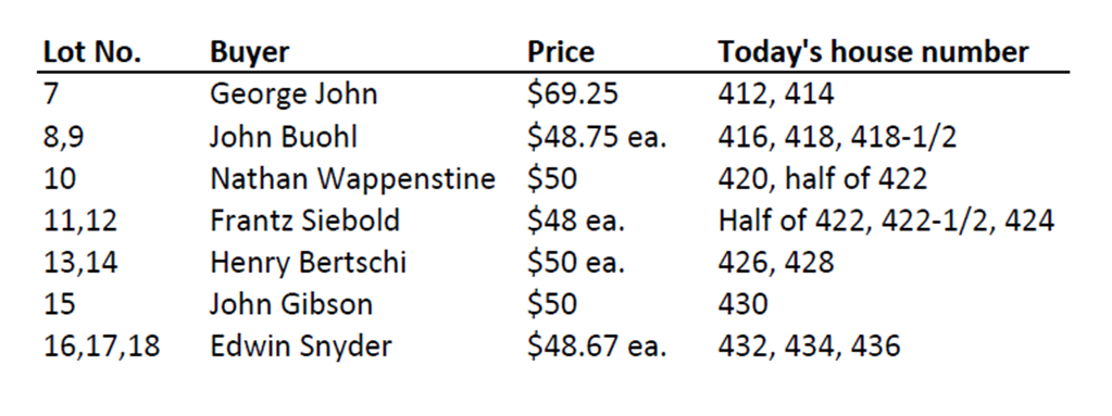
The public sale of Locher’s building lots on October 5, 1872 went well. A dozen lots on the southeast side of Poplar were sold that day, ranging in price from $48 apiece for lots 11 and 12, to $69.25 for lot 7 (the widest lot). The purchasers were required to pay half the price by April 1, 1873, and the other half, with interest, by April 1, 1874. The twelve lots that were sold that day in the 400 block of Poplar were:
The building of houses on the recently purchased lots began shortly after the public sale. Most of the new lot owners kept their lots at the original 20-foot widths, but a few lot owners subdivided their lots before houses were built. Lot 7, with an original 30-foot width, was divided into two 15-foot wide lots. Also, two pairs of 20-foot wide lots, each pair having a total of 40 feet of width, were each divided into three lots a little over 13 feet wide. Lots 8 and 9, and lots 10 and 11, were combined and then subdivided in this way, so that four 20-foot wide lots became six 13-foot wide lots. The result was that thirty-four houses could be built on the original thirty-one lots.
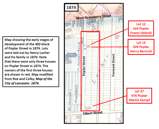
The first two houses to be built were completed by 1874 (see 1874 map). They were built by Frantz Siebold (lot 12) and Henry Bertschi (lot 13). Today those houses are 424 and 426 Poplar, across the street from the SoWe office in the rear of the St. Joseph Church annex. The third house built was that of Martin Kempf, who bought lots 36 and 37 for $475 about six months after the public sale. Kempf built a larger house on lot 37 on the corner of Poplar and Filbert, where he opened a beer saloon on the first floor. Kempf’s house and saloon is now 476 Poplar.
The purchase of lots from Locher’s heirs, and the building of houses on the lots, continued for another fifteen years. In 1880, eight years after the public sale, eight houses had been built (416-424, 476). Just six years later, in 1886, another twenty houses had been built (412-414, 426-430, 434-436, 442-448, 456-472). Finally, by 1888, sixteen years after the public sale, all thirty-one lots had been sold and all thirty-four houses had been built (see 1897 map). Every house was a 2-1/2-story brick Victorian house.
In a little more than fifteen years (1872-1888), the southeast side of the 400 block of Poplar Street had gone from boundary stakes in the ground to fully built out, testifying to the intense development of the Hill that was occurring at that time. Today, the same thirty-four houses that were built more than one hundred and thirty years ago are still present, making the 400 block of Poplar perhaps the only block on Cabbage Hill where all the original houses pre-date 1890 and are still in use.
Today’s residents of the 400 block of Poplar are living with a lot of history just waiting to be discovered. If you live in one of those houses, the history of your property dates back to the lots laid out by Henry C. Locher in 1870. That would be a good starting point from which to develop the rest of your house’s history to the present. If you are interested in researching your house’s history, you can contact me at SoWeCommunicate@sowelancaster.org, and I will try to point you in the right direction.
Oscar
Shane’s pigeon arrived at its loft behind the Shane house at 608 High Street at
4:44 p.m. on June 10, 1908. The pigeon had been released, along with fellow
competing pigeons, in Concord, North Carolina, at 5:10 that morning. It had
averaged almost 35 miles per hour over its 400-mile journey back to Lancaster, winning
the competition arranged by the members of the Lancaster District of the
International Federation of Homing Pigeon Fanciers (IFHPF).
The
breeding, raising, training, and racing of homing pigeons became a popular
hobby on Cabbage Hill in the late nineteenth and early twentieth centuries. The
sport of pigeon racing had been imported from Europe in the 1860s, with most of
the bred-for-speed and bred-for-homing-ability pigeons coming from Belgium. In
the U.S., it first blossomed in the big East Coast cities of Boston, New York,
and Philadelphia, but by the 1880s pigeon racing had found its way to
Lancaster.
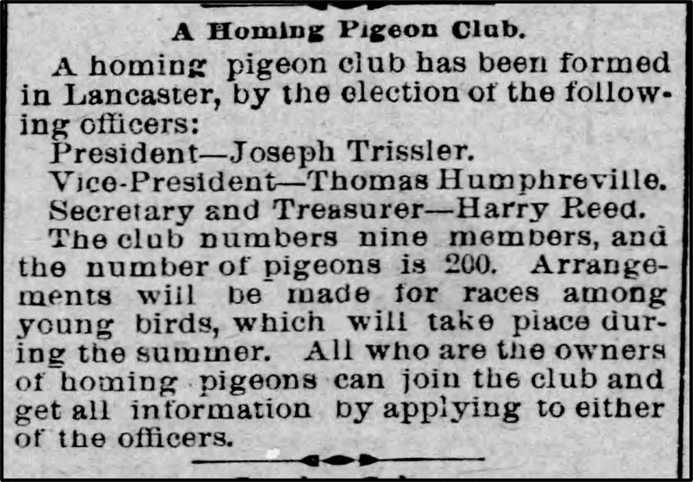
Article about the formation of the first homing pigeon club in Lancaster, The Lancaster Examiner, February 20, 1889.
The first
organized group of homing-pigeon owners in Lancaster was established in early
1889. It was called the Lancaster Homing Pigeon Club and it was made up of nine
members owning some 200 pigeons. By the early 1890s, at least several pigeon
owners from Cabbage Hill had joined the club—the aforementioned Oscar Shane
(556 Manor), William Paulsen (560 Manor, the author’s great grandfather), and
Adam Danz (606 High). In 1894, a second racing club was formed, the Hillside
Homing Pigeon Club, possibly named so because it was headquartered on the Hill.
How did
pigeon racing work? The clubs organized races on weekends during the spring,
summer, and fall, with the participating members shipping their pigeons in
crates by train to wherever the starting point of the race was. Most of the
starting points were southward, usually in Virginia or the Carolinas. Each
racing pigeon would have a metal band on one of its legs inscribed with the
owner’s initials and a unique identifying number. At a designated time, usually
in the early morning, all the pigeon contestants would be released and the trek
home to Lancaster would begin. The pigeons would use their acute sense of smell
and their uncanny ability to discern minute differences in the Earth’s magnetic
field to find their way home to where they knew they would be fed and reunited
with their mates.
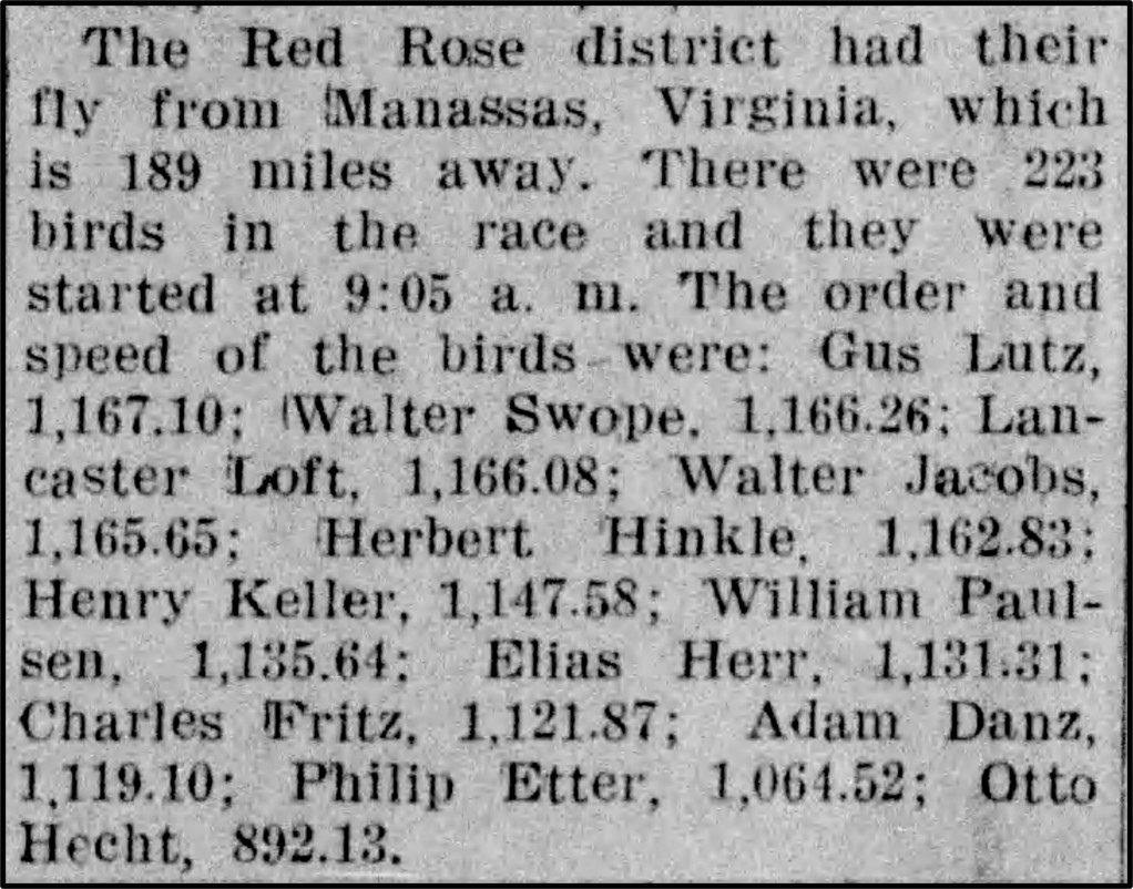
Results of a race of the Red Rose District of the IFHPF, in The Intelligencer Journal, May 18, 1908. The average speeds are given in yards per minute.
Back in
Lancaster, an official judge would be stationed at each loft where a competitor
made its home, ready to read off from synchronized clocks the exact time at
which each pigeon would alight at the door to its loft. The judges would then
compare the times, and award a prize to the owner of the winner and runners-up.
The prizes were often of significant value, and an owner with an especially
accurate and fast-flying pigeon could offset the expense of his hobby.
But it was
not always easy or pleasant for the pigeons. Often, some would not make it home,
especially when flying through bad weather. In one particularly bad storm in
1911, only 15 of 73 pigeons made it home to Lancaster within four days of being
released in Newberry, South Carolina. Others would finally arrive long after
the race was over. For example, in at least two extreme cases, Hill pigeons
returned nearly two years after their release.
On the other
hand, there were some feel-good stories as well—for example, after one loft owner’s
death, his many pigeons were sold to a place in New York for butchering. A few
days after their arrival in New York, two of the condemned pigeons were found
back at their original loft, “strutting around the old coop, contented and
cooing”, having escaped and found their way home. One hopes double jeopardy
ensured them a long happy life.
Perhaps the
high tide of early pigeon racing in Lancaster occurred in the latter part of
the first decade of the twentieth century. In 1908, there were three clubs in
Lancaster, each with at least ten members and many hundreds of pigeons. The
Lancaster District of the IFHPF, with about half its members being from Cabbage
Hill, and the Red Rose District of the IFHPF, with nearly all of its members being
from the Hill, were two of the clubs. The third club was the Keystone Homing
Pigeon Club, which was not affiliated with the IFHPF and which had no members
from the Hill.
To give an
idea of the makeup of these clubs, here are nine Cabbage Hill members of the
Red Rose District, with their 1907 addresses:
Gustavus F. Lutz
529 High
Herbert J. Henkel 436 West Vine
Henry P. Keller 636
Lafayette
William Paulsen 560 Manor
Elias E. Herr 638 Lafayette
Charles J. Fritsch 812 High
Adam J. Danz 826
St. Joseph
Philip Etter 725 High
Otto Hecht 530 Lafayette
Of these nine
club members, six of them lived on High and Lafayette. Their average age was about
35, and all of them were tradesmen, with six of them working in the cigar
industry. Only two of them had been born in Germany, but the majority of them
were sons of German immigrants.
In the
decade from 1910-1920, which included World War I, the Red Rose District of the
IFHPF continued to actively compete. Even during the war, the club continued
racing, but the number of Hill members dwindled to just four—Oscar Shane (657
High), Charles J. Schill (618 West Vine), Frank Wechock (420 High), and Frank
Martin (710 St. Joseph). Perhaps this had something to do with the members of
German heritage wanting to avoid the spotlight during the intense anti-German
sentiment directed at Cabbage Hill during the war.
In 1917, Red
Rose member Charles Schill was elected Secretary of the entire IFHPF, and in
his official capacity he was asked by the Army to provide an inventory of all
the homing pigeons affiliated with the IFHPF. The inventory was essentially a
draft registration for homing pigeons, because there was a need for their
service at the European war front. The pigeons were expected to be “doing a bit
as a patriot, to help our country in this great crisis.” In fact, in May 1918,
General Pershing directed 3,000 homing pigeons and 100 trained handlers to be
dispatched to the European front.
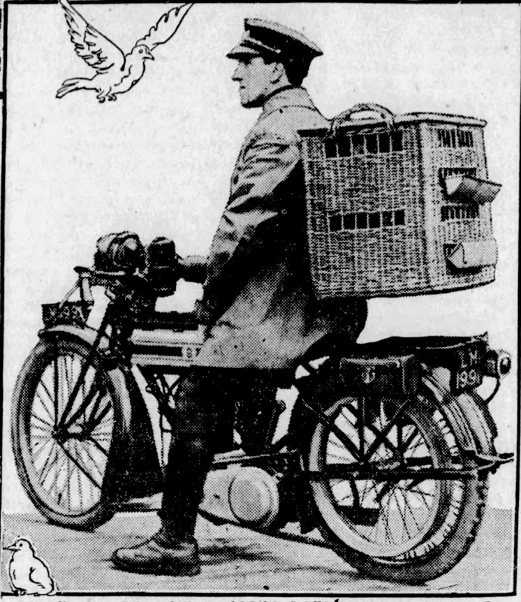
A dispatch rider taking homing pigeons to the trenches in WWI, The Inquirer, May 18, 1918.
Once at the
front, homing pigeons were used to deliver messages back from the front lines.
As a 1918 newspaper article noted, “They did work which the wireless, telegraph
and telephone could not do under certain conditions.” Homing pigeons with
rolled messages in containers banded to their legs would circle up from the
trenches, dodge through the shells, bullets, and poison gas, and deliver their
messages to military headquarters miles behind the battle lines. They were said
to have a 97% success rate, and there was at least one pigeon who was hit by
German fire and still was able to deliver its message.
Back on
Cabbage Hill after the war, pigeon racing continued for many years. As just one
example, Charles Schill, the Secretary of the IFHPF during WWI, went on to own race-winning
homing pigeons well into the 1940s. However, about ten years ago, due to
complaints of unsanitary conditions in backyard lofts, Lancaster was forced to
ban the keeping of pigeons within the city limits. That ended more than 100
years of the homing-pigeon sport in the city, but many rural clubs still exist,
and a large national network of racing aficionados still compete in much the
same way as before.
Today, if
you stop on Cabbage Hill and listen carefully, especially around High and
Lafayette, you might be able to pick up the last echoing coos from the golden
age of homing-pigeon racing on the Hill.
In the mid-19th
to early 20th centuries, Cabbage Hill boasted numerous hotels. Most
didn’t look like the typical hotels of today, but instead looked like larger
houses, with saloons on the first floor and rooms for rent in a rear wing. The
proprietor and his family usually lived on the second floor above the saloon. Often
hotels had a main front door for the saloon and hotel, and a second door off to
one side for the proprietor’s upstairs living quarters. Most old hotels were on
corners at intersections.
By far the
earliest (1745) hotel near Cabbage Hill was the Golden Plough (later the Plow
Tavern) at West King and Charlotte, just north of the Hill proper (razed in
1928). Probably the earliest hotel actually on the Hill was the Lafayette Hotel
operated by George Hinkle in the 400 block of Manor Street in the mid-1840s (no
longer there). After the Lafayette went out of business in the early 1850s,
there were no more hotels on the Hill until after the Civil War, although there
were always a couple saloons.
Between the
Civil War and the beginning of the 20th century, eight iconic hotels
were established in the historic core of the Hill, bounded by Manor, West
Strawberry, Fremont, and Fairview. Each of these eight hotels flourished at
least until the back-to-back challenges of Prohibition and the Great Depression,
which put several of them out of the hotel business. The saloon part of their
business, however, persisted through Prohibition, with many of them becoming
speak-easies and occasionally running afoul of the Volstead Act. After World
War II, many of the saloons in the old hotels were transformed into cafes,
taverns, and bars through the late 1900s. Although none of the eight iconic
hotels is a hotel anymore, all eight hotel buildings survive, and some still
house successful businesses.
In their heyday,
the eight hotels were the hubs of many Hill activities. Political meetings,
speeches, and rallies often took place in the hotels, sometimes drawing
hundreds of people. Many of the hotels served as polling places as well.
Special events and celebrations often took place at the hotels, and music and
dancing were common on weekends. Athletic, shooting, and other competitions
between different hotel were frequently arranged. And, of course, Hill
residents spent many a night gathered around the long bars drinking locally
brewed beers. Occasionally, fights would break out and the police would be
called.
The eight
iconic Hill hotels are briefly described next, starting with the oldest:
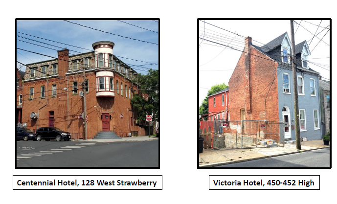
Centennial
Hotel, 128 West Strawberry—Established by Samuel Erisman in 1865, and named in 1876 during the
Nation’s 100th birthday, the Centennial started out as a saloon in a
one-story frame building. In 1892, the old building was replaced with a 3-story
brick one (the current building) with 15 rooms, one bath, and a large bar room.
Edward Kirchner ran the hotel and saloon during the challenging Prohibition
years. Obie Miller’s Steak House operated in the building from the mid-1940s to
the mid-1980s, and then Strawberry Hill Restaurant from the mid-1980s to 2012.
The scars of two large saloon windows remain near the angled front door.
Victoria
Hotel, 450-452 High—In
1865, Christian Diehl built a 2-story frame building and opened a saloon in it.
When he died in 1877, his wife Victoria took over running the saloon, added a
hotel component, and named it Victoria Hotel. She replaced the frame building
with the current brick one about 1890. Joseph Fritsch ran the hotel and saloon
until Prohibition in 1920. The hotel business closed in 1937, and Ziegler’s
Café operated here in the 1940s. The outline of the old hotel entrance is still
visible in the brick pattern on the façade.
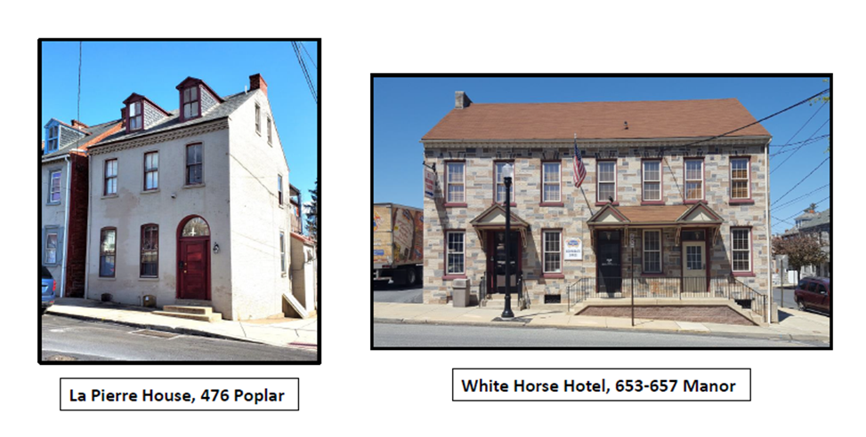
La Pierre
House, 476 Poplar—Martin
Kempf built the current building and opened it as a saloon in 1873. After
Kempf’s death, John Snyder took over in the 1880s and 1890s and added the hotel
business, calling it La Pierre House. Lancaster brewer Charles Wacker bought
the hotel and saloon in 1900 and Charles A. Kirchner ran it for him until 1930.
At that time, the hotel business closed, and Albert Karch ran Fibber’s Café in
the old saloon until 1953. Since then, it has been Danz Café, Brau House,
Farrell’s Café, and My Linda’s Tavern, which closed in 1992.
White
Horse Hotel, 653-657 Manor—Albert Kohlhaas opened a saloon at this location in 1874, and built the
current building as the White Horse Hotel about 1880. He sold the hotel to
Frank Rieker of Rieker’s Brewery in 1899. John Kirchner ran the hotel for Rieker for
about 20 years, followed by Thomas Goodhart for 15 more. Since the 1940s, the hotel
has been closed, but numerous drinking and eating establishments have used the
building—Noden’s Café, Bishop’s Café, Bartnichak’s Café, and most recently,
O’Henry’s, which closed in the 1980s. Kunzler’s now uses the old hotel as its
corporate offices. Multi-colored formstone now covers the original brick
exterior.
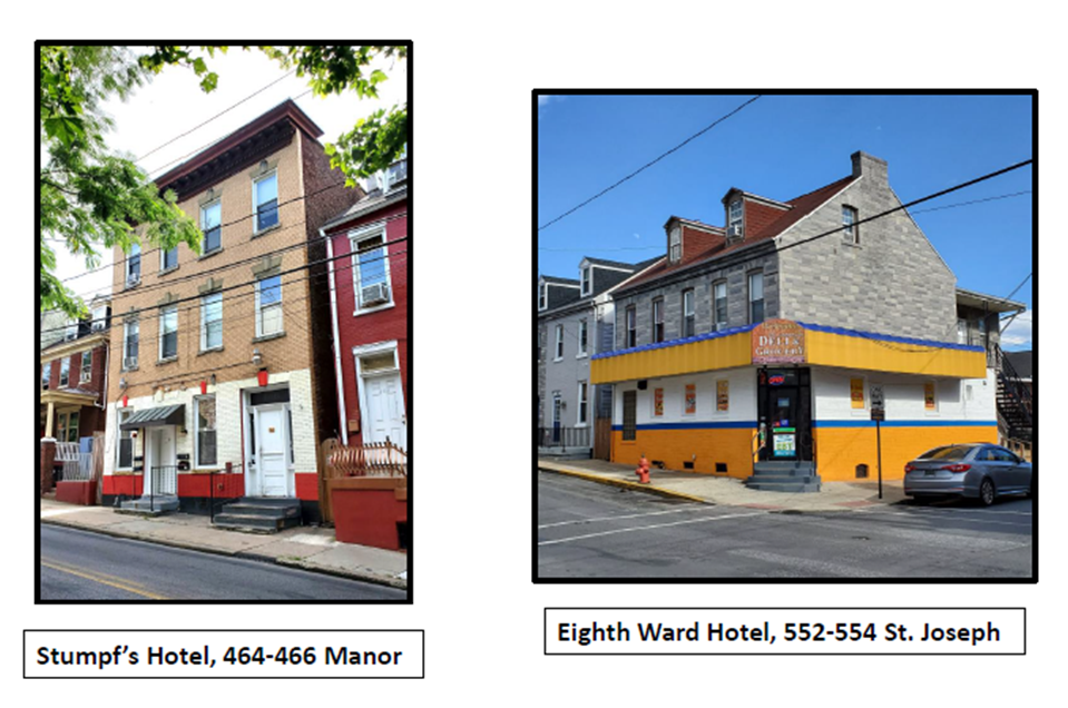
Stumpf’s
Hotel, 464-466 Manor—Started
as Charles Vogt’s saloon in 1874, the original building became William
Schneider’s Manor Street Hotel in the 1880s and 1890s. John Stumpf built a new
hotel (the current building) on the site in 1902, with 16 rooms, hot and cold
running water, and a huge cherry bar. Stumpf ran his hotel until 1937. After
Stumpf’s Hotel closed, a series of owners operated cafes, taverns, and bars
there, including Pat & Denze Café, Manor Bar, Gold Brick Tavern, Manor
Tavern, and Cosmos Bar & Grill, which closed in 2011.
Eighth
Ward Hotel, 552-554 St. Joseph—Alexander Gerz built the current building about 1874 as the
new Green Cottage Hotel. Gerz’ heirs sold the hotel to Lucas Fritz, who ran it
as the Eighth Ward Hotel until the late 1880s, when it was taken over by Fritz’
son Charles until about 1900. William Hoenninger, Jr., ran the hotel and saloon
until about 1915. During Prohibition, Albert Hall sold soft drinks (at least) out
of the dormant saloon. The hotel part of the business closed during the Great
Depression. John Lermer and his wife Fannie ran Lermer’s Café from about 1940
to 1970, and from the late 1970s to 2012, it was the Starting Gate Inn. Formstone
now disguises any covered-up doors and windows from the old building.
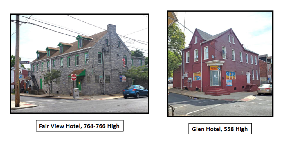
Fair View
Hotel, 764-766 High—In
1894, Frank Schwarz bought a relatively new store and house on the corner of
High and Fairview and a few years later he opened the Hotel Schwarz. Next, Casper
Kirchner ran the hotel until 1910, naming it the Fair View Hotel. Matthew
Miller, Carl Koenig, and Albert Bishop were the main proprietors of the Fair View
for the next 30 years. From 1947 to 1990, William Steinbaecher took over,
naming it Steinbaecher’s Hotel and expanding it farther along High. From the
early 1990s to today, it has been O’Halloran’s Irish Pub. Formstone covers up
any remnants of doors and windows from the old hotel and saloon.
Glen
Hotel, 558 High—The
current building was built in the early 1890s as a grocery store for John Kaetz.
By 1903, it was the Glen Hotel licensed to George Kirchner, and one owner
later, William Kirchner was the proprietor until 1909. Several different men
operated the Glen from 1909 into the 1930s, when the hotel closed and a series
of cafes and taverns and other businesses took over, including Hammel’s Café, Koenig’s
Café, Armand’s Tavern, the Glen Tavern, Tan Hoa Grocery, Peniel Church, and
currently Sunshine Nursery Daycare Center.
The golden
age of Cabbage Hill hotels is long past, but the buildings remain to remind us
of how important they were to the social lives of Hill residents. Now the rooms
in the old hotel buildings are apartments, as are many of the proprietor’s
quarters on the second floor. But many of the old first-floor saloons have been
converted for businesses, which is key to maintaining some of the neighborhood atmosphere
of the old days on today’s Hill.
One last
thing: Did anybody notice while you were reading this how many of the hotel proprietors
were Kirchners? Edward, Charles, John, Casper, George, William—the Kirchners
must have had the hospitality business in their genes!
Life on old Cabbage Hill had many
qualities worth waxing nostalgic about—neighborhood solidarity, a wide range of
owner-operated neighborhood businesses, and vibrant social, cultural, and
religious institutions, among others. But life in the good old days on the Hill
also had its serious drawbacks, some of the worst of which were frightening
outbreaks of infectious diseases, including smallpox, typhoid fever, cholera, diphtheria,
and consumption (tuberculosis), in the latter half of the nineteenth century.
Scientific understanding of the causes
of contagious diseases, and therefore their proper prevention and treatment, was
just in its infancy in the late 1800s. Ignorance and misinformation were rampant,
as were fraudulent prevention and treatment recommendations. Doctors did the
best they could, some heroically, but in many cases all they could do was try
to alleviate the victims’ suffering.
Today, these once feared diseases have
been eradicated in the U.S. through the implementation of public-health measures,
including sanitation and vaccines. Because we are no longer threatened with
these diseases, it is hard for us to imagine how frightening and panic-inducing
they used to be. But the impacts on communities could be truly devastating.
Cabbage Hill was often hard hit when
these diseases visited Lancaster. In some outbreaks, many dozens of Hill
residents came down with the disease, and numerous residents died. The city
Board of Health did its best to monitor and control the diseases, and there are
records of the statistics and public-health responses related to each outbreak.
It is important to remember, though, that behind the faceless statistics were
real families that were changed forever.
In the late spring and summer of 1883,
Lancaster endured a smallpox outbreak that severely impacted a family on the
slope of Dinah’s Hill, on the northern edge of Cabbage Hill. On May 8, Charles
Carr, a 20-year-old bill poster, was committed to the county prison for 45 days
on a charge of drunkenness and disorderly conduct for breaking a transom window
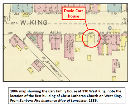
at the Seventh Ward Hotel. Charles lived with his parents, David and Kate Carr,
and seven siblings in a 1-1/2-story frame house at 330 West King Street.
Charles’s family immediately began the
process of trying to get him released through a writ of habeas corpus. In the
meantime, six inmates of the prison, including Charles, had come down with what
appeared to be the early stages of smallpox, a highly communicable disease
caused by the variola virus. The early symptoms of smallpox are fever, back
pain, and red spots on the face, arms, and legs. The prison-keeper was reluctant
to acknowledge this threat to his prison, and despite the warning symptoms,
Charles was released on bail to his family on May 22, just two weeks after he
had been committed. Two of Charles’s older sisters, Annie and Katie, took on
the job of nursing him back to health at their crowded home on West King.
But unlucky Charles was soon beyond
help, and he died on June 4. By then, Annie and Kate had contracted the
disease. Katie, age 25, died June 10, and Annie, age 26, died June 18. By that
time, several of their siblings also had contracted smallpox, and the disease
took brother John, age 18, on June 21; sister Ida, age 17, the next day; and
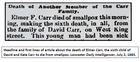
brother Elmer, age 22, on July 2. In less than a month, six of the Carr’s adult
children had died from smallpox. Of the eight children who had still been living
at home, only George, age 23, and Emma, age 15, survived, and Emma would die
the next year from a “lingering illness”, possibly related to the same outbreak
of smallpox that had devastated her family.
Many neighbors chipped in to provide
support for the Carr family during their crisis, although David Carr refused to
accept any donations. Unfortunately, however, one person saw an opportunity to
take advantage of the family. On the night of July 9, just a week after the
sixth Carr child had died, someone broke into the Carr’s fenced backyard and
stole nearly 100 chickens, prompting the local newspaper to editorialize that
“the thief deserves to be shot”.
The Carr family was the hardest-hit
family, but throughout Lancaster, 85 people contracted the disease, and 15
people died. The prison-keeper, the prison doctor, and the lawyer and judge who
had overseen Charles Carr’s release, were all criticized in the local
newspapers, as was the Board of Health for not acting sooner and more
forcefully. A new position of Health Commissioner was added to the city government,
and three special police officers were assigned to guard the houses that were
under quarantine during the outbreak. The new Health Commissioner led a sanitary
cleanup and free vaccination effort in the hardest-hit areas of the city.
Slowly, the city went back to its normal routines, but for the Carr family,
life would never again be normal.
Eight years later, in the spring of
1891, a different scenario involving an infectious-disease outbreak unfolded right
in the center of Cabbage Hill. The disease was typhoid fever, and the location
was the neighborhood around the intersection of New Dorwart and High Streets.
This time, the disease was transmitted by way of water from a polluted backyard
well.
In September 1890, John Dinges, a
carpenter living at 434 High Street, bought a house (602 High) on a large lot
on the south corner of the intersection of High and New Dorwart Streets. Behind
the house was a shallow well that had been dug when the house had first been
built, at least 20 years earlier. The well was in the floodplain of a small
stream called the Run, which in the 1870s and early part of the 1880s ran where
New Dorwart Street is today.
The well also was only about 12 feet
away from the house’s cesspool, making it likely that human waste from the previous
residents of the house had made its way to the well. Typhoid fever is caused by
a Salmonella bacterium that is found in human excrement. The bacteria that
cause typhoid fever are easily transmitted in water. The symptoms of typhoid
include fever, headache, abdominal pain, vomiting, and eventual delirium.
When Dinges acquired the lot and
house, the well had been abandoned for some time, but he installed a pump on it
and put the well back in use. He did not move his family into his new house,
continuing to live at 434 High, but his family started using the well behind
the new house. Dinges also allowed a few other families to use the well,
including neighbors around the corner on New Dorwart—Andrew Braungart and his
wife and seven children. Braungart’s wife was the sister of Joseph Hildmann,
who lived at 414 Poplar with his family, and Hildmann’s family was permitted to
use the well also. At least two other families who were neighbors of Dinges
also began using the well.
Soon after Dinges and his neighbors began
using the well, many of them came down with typhoid fever. Dinges was the first
to contract the disease, and he died on May 24. At the time of his death, a
local newspaper reported that 20 other people had become sick with typhoid.
This number included Dinges’s three children, all nine people in the Braungart
family, and Joseph Hildmann and his wife and children.
When Dinges died, the city Health
Commissioner directed the well to be shut down. Dinges’s widow refused to do
so, so the Commissioner had the pump handle removed and announced that anybody
using the well would be prosecuted. Although some 20 people had already contracted
typhoid fever, no new cases would appear after the well was shut down.
One more person died in the typhoid
outbreak. David Hardy, a 30-year-old tobacco packer and shortstop on the “Ironsides”,
a city baseball team, was admitted to St. Joseph’s Hospital on May 28 and died
on June 2. Hardy had been boarding on Fremont Street with his wife and one
small child.
All the others recovered eventually,
but not without a disturbing incident involving the Braungart family. Andrew
Braungart and three of his children were sick enough to be admitted to the
hospital in late May. On June 5, Braungart was given permission to leave the
hospital for a few hours to visit the rest of his family at home, including a young
daughter who had been too sick to be taken to the hospital. On his way home, Andrew
stopped for whiskey and arrived home drunk, where he “abused his family”. The
authorities were called, and the sick daughter was removed to the hospital for her
own safety.
In this 1891 typhoid fever outbreak,
the city was better prepared than it had been in the smallpox outbreak in 1883.
The Health Commissioner position that was established in 1883 was right on top
of the typhoid outbreak as soon as the first death was reported, and his quick actions
put a halt to any further spread of the disease. Also, while the crisis was
still evolving, the city Water Committee decided to install a 6-inch water pipe
under New Dorwart to replace the lost water supply of the polluted well. The
testing of water in all the wells in the city also was begun. However, as
efficient and effective as the city’s response had been, it was still too late
for the Dinges and Hardy families that were forever impacted by the typhoid
outbreak.
Today, sadly, we continue to be
plagued by outbreaks of new infectious diseases caused by viruses and bacteria.
Each new outbreak has some distinctly unique features, but our reactions and
behaviors often seem to follow the same sequence of steps and missteps as we
try to deal with them. Revisiting past outbreaks like the ones in 1883 and 1891
can perhaps help us make better decisions about what to do and what not to do
during new outbreaks. Reviewing past outbreaks like these two also reminds us that
the good old days on Cabbage Hill and the rest of Lancaster included some
pretty bad moments.