Jim Gerhart
Sometimes an image inadvertently captures a scene just before it changes forever, locking in all the little details that will never be the same again. A lithograph of Lancaster as seen from the southwest in 1852 is just such an image. It was drawn with such attention to detail that it is almost as good as a photograph. But in one way, it is even better than a photograph because a photographer in 1852 would not have had the specialized equipment to take an almost 180-degree panoramic photograph.
The lithograph is entitled “View of Lancaster, Pa.” It was drawn by Charles R. Parsons in 1852 and published by James T. Palmatary in January 1853. Parsons was an English immigrant who apprenticed under George Endicott in New York City, and “View of Lancaster, Pa.”, done when he was thirty-one, was one of the first works of his long and distinguished career. Palmatary, also an English immigrant, was a famous lithographer in the mid-nineteenth century, who published many innovative lithographs of birds-eye views of major American cities. Parsons and Palmatary executed their work well, as an article in the Lancaster Intelligencer of January 18, 1853, advertised their 18×34-inch product as being “drawn from nature” and having a “rich and life-like appearance”.
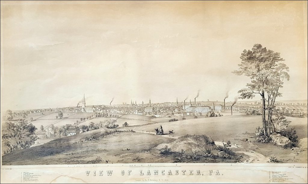
The “View” shown in the lithograph extends from Manor and High Streets (Bethelstown) on the left (northwest) to Woodward Hill Cemetery on the right (southeast). It shows Lancaster as it appeared in 1852 to an artist sitting on a hill with an unobstructed view of the city. It quite faithfully reproduces churches, schools, factories, public buildings, and other landmarks of 1852 Lancaster with exacting precision. It includes some landmarks that had only recently been added to the city’s skyline, such as Fulton Hall (1852), Woodward Hill Cemetery (1852), Conestoga Steam Cotton Mills (1847), St. Joseph’s Catholic Church (1849), and even the new County Courthouse (1852) shown under construction in the scene.
But even more noteworthy for the history of Cabbage Hill is what is captured in the foreground of the “View”—a nearly empty landscape that had no inkling it was about to experience a virtual frenzy of development leading to the densely built and populated neighborhood we see today. Open pastures separated by fences and tree-lined farm lanes dominate the foreground of the lithograph. There are only two buildings seen on the central part of what would soon be called Cabbage Hill—St. Joseph’s Church in the left rear foreground and a house in the left middle foreground.
The topography of the Hill, which is difficult to fully grasp today amid all the houses, is clearly depicted. One can see that Cabbage Hill is really two hills separated by a valley. The hill in the foreground where Charles Parsons stood to draw the “View” is the southern hill and the hill where St. Joseph’s Church stands is the northern hill. The valley traversing the scene from left to right is the valley in which a tributary of Hoffman’s Run flowed on its way to a larger stream along South Water Street.
Several features that are important to the history of Cabbage Hill are captured in the scene. On the far left, several rows of houses trail away from the city toward the edge of the drawing. This is the only part of today’s Cabbage Hill that was developed in 1852. It is the neighborhood of Bethelstown along the first two blocks of High and Manor Streets that was laid out by Samuel Bethel, Jr. in 1762, and that had just begun to finally take off in the late 1840s. In the right center of the drawing are the three large buildings of the Conestoga Steam Cotton Mills on South Prince Street. In the late 1840s, these three mills and St. Joseph’s Church played key roles in attracting the new residents that were about to lead to the explosive growth of Cabbage Hill.
New streets and future streets can be identified on the lithograph. St Joseph Street can be seen as not much more than a fence-lined farm lane emanating from the left side of St. Joseph’s Church and heading down to the tributary stream in the valley, where some thirty years later, New Dorwart Street would be constructed after the stream was drained into a large sewer beneath the street. To the right of St. Joseph Street, another fence-lined and tree-lined lane—Poplar Street—follows the same slope down to the valley bottom (are the trees lining this lane by any chance poplar trees?). Less well defined to the left of St. Joseph Street is another parallel fence line that looks like it might be the future site of West Vine Street. A similar fence line to the right of Poplar Street could be the future Fremont Street, as it seems to be leading to the house in the left foreground, which stands on Fremont Street today.
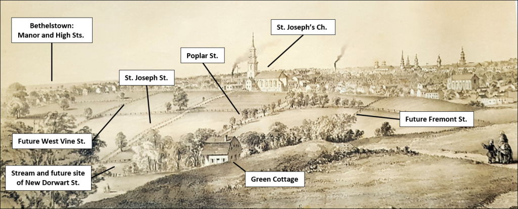
That house, partially hidden from Parsons’ view by the southern hill, and nestled on the lower slope above the valley floor, was the summer cottage of Catherine “Kitty” Yeates, daughter of Jasper Yeates, prominent lawyer and judge of late eighteenth and early nineteenth century Lancaster. The house, known as Green Cottage, was built about 1820 as Miss Yeates’ summer cottage, and was the first house other than small farmhouses in the central part of Cabbage Hill. The artist even captured the slight change in angle of the gambrel roof that can only be seen in today’s roof upon close inspection. The house was later owned by Alexander J. Gerz and used as a hotel, and it still stands today at 613 Fremont Street, adapted for use as apartments.
The buildings in the “View” are drawn with such accuracy that one can use their positions relative to each other to locate the general area where Charles R. Parsons positioned himself to make the drawing. The spot where Parsons set up his easel was the hilltop near where Frank’s Garage is located in the 600 block of Union Street. Only from that location does the alignment of the Yeates cottage with St. Joseph’s Church match the alignment in the “View”. And only there do the relationships among the buildings of the Conestoga Steam Cotton Mills (now Water Street Rescue Mission , Carter & MacRae Elementary School, and the office of the School District of Lancaster), agree with the relationships in the lithograph
Fortunately, a high-quality original of this lithograph survives in the Wheatland Collection at LancasterHistory. It currently hangs in what appears to be its original frame in the rear stair hall at Wheatland. It provides a rare glimpse of a moment in time, fortuitously captured more than 165 years ago, just before the central part of Cabbage Hill blossomed with development.