Jim Gerhart, September 2019
The title of the 1992 film, “A River Runs Through It”, once applied to Cabbage Hill. Up until the early 1880s, a stream flowed where New Dorwart Street is today. It was a tributary to a larger stream that drained a watershed that covered about two-thirds of Lancaster City. The entire stream system has long since been buried in sewers that run under some of the major streets of the city.
When Lancaster was founded in 1729, James Hamilton named one of its north-south streets Water Street, and with good reason. A stream ran from near the intersection of West Walnut and North Arch in northwest Lancaster, southward down most of Water to Engleside, where it emptied into the Conestoga River. The stream was called Roaring Brook in the mid-1700s; Bethel’s Run from the late 1700s to early 1800s; Hoffman’s Run from the early 1800s to late 1800s; and finally Gas House Run around the turn of the 20th century, before it completely vanished.
There were several tributaries to the larger stream that flowed down Water, including one along West King between Christ Lutheran Church and Water; one along West Vine between what is now the Convention Center and South Water; and one from Union through Brandon Park to South Water. But the largest tributary was the one in Cabbage Hill that used to flow where New Dorwart is now, which was sometimes referred to as simply “the Run”.
The Run began at several springs and seeps northwest of Manor between Dorwart and Caroline. From there, it flowed southeast a little more than a half mile before it reached the larger stream on South Water. The area of the Run’s watershed was about 250 acres, covering most of Cabbage Hill. The bedrock beneath the Run was limestone, like under the rest of the city, and the stream banks were lined with trees and wetland vegetation.
Comparing the Run to same-sized streams in similar settings in Lancaster County today, it is possible to estimate its flow characteristics. The Run was likely only a few feet wide and less than a foot deep most of the time, but probably reached more than twenty feet wide and several feet deep during heavy rains. Between storms, the flow rate was probably only a couple hundred gallons per minute, but during storms, the rate would have reached several thousand gallons per minute, enough to flood adjoining streets and basements. High flows would have made it difficult to cross the Run by foot, horse, or wagon, without a bridge.
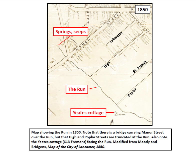
In the early days of development on the Hill, the building lots containing or adjacent to the Run were among the most desirable lots to own. The Run provided not only water for drinking, cooking, washing, and conducting business, but also a conduit for carrying away the wastes generated by residents and businesses. The first house built in the central part of the Hill—Catharine Yeates’ summer home, known as Green Cottage, now 613 Fremont—was built fronting the floodplain of the Run, taking advantage of the benefits of being located near flowing water (see 1850 map). However, when Lancaster’s public water supply became available in the mid-1800s, the problems of flooding, insects, rodents, odors, and pollution associated with the Run soon outweighed the benefits.
In 1878, the city developed a plan for the addition and extension of numerous streets. On the Hill, the plan included many street improvements, including the opening of Fremont and Union and the extension or widening of Filbert, Laurel, Hazel, and Wabank. The plan also included the opening of a new street, soon to be called New Dorwart, which was to be built from Manor to Union, where the Run and its floodplain were located. In 1880, a trench was started down the middle of the street to contain the stream. In 1883, the construction of a six-foot-high brick sewer was started in the trench. By the late 1880s, the sewer had been completed from Manor to Poplar, the new street had been built over it, and new houses had begun to spring up on both sides. By the early 1890s, the sewer had been completed all the way to Union. The Run had disappeared from view, a casualty of development.
But, before it was diverted underground, the Run had a major impact on the establishment of the streets on the Hill. Manor Street, which had existed in the early 1700s as the road to Blue Rock on the Susquehanna River, had long required a bridge over the Run (see 1850 map). High Street, on the other hand, did not extend beyond the Run in 1850, being truncated by the difficulty of crossing the Run during high flows. The newly constructed Poplar Street also was truncated by the Run in 1850.
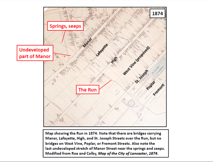
As the Hill developed rapidly from the late 1860s to the mid 1870s, additional streets were extended to the Run and required bridges. By 1874, in addition to a bridge having been built to carry High over the Run, Lafayette and St. Joseph had bridges over the Run as well (see 1874 map). But the recently proposed West Vine and the fledgling Poplar and Fremont did not have bridges. Instead, they had to be forded when the flow was low enough to safely do so.
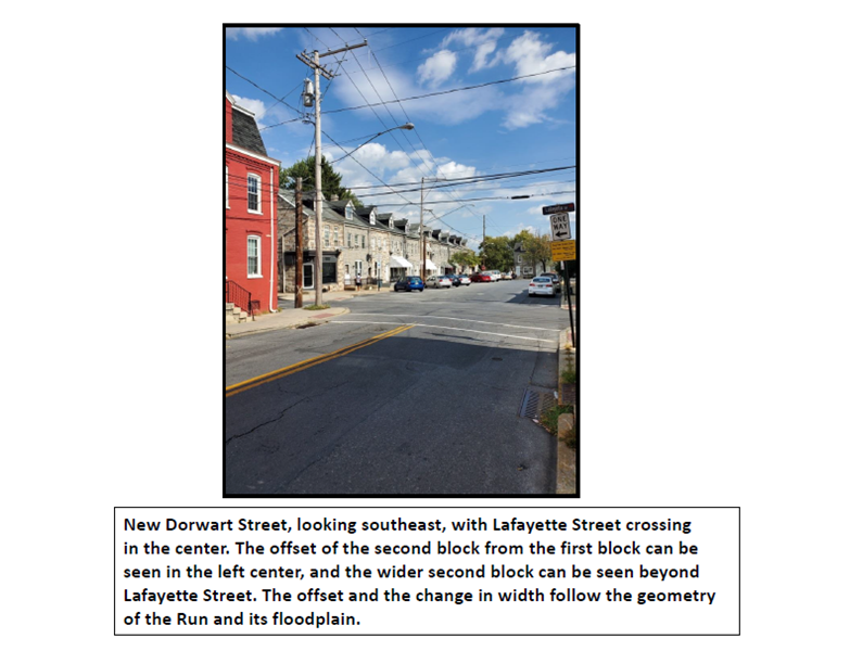
Prior to being buried in a sewer, the Run also affected the geometry of the design for New Dorwart. Due to the slightly northeast-bending shape of the Run east of Manor, and the resulting widening of the floodplain northeastward, New Dorwart was offset from the first to the second block, and again from the second to third block. The resulting stair-step pattern along the northeast edge of the first two blocks of the street remains today. Also, the wider floodplain where the Run curved to the northeast is probably the reason that New Dorwart between Lafayette and High is about twenty feet wider than elsewhere.
Another way that the Run affected early development was that the northwest side of Manor between Caroline and Dorwart was the last stretch of Manor to be developed (see 1874 map). The wetlands associated with the springs and seeps at the head of the Run made that area perpetually wet and difficult to build on. Even as late as 1897, almost two decades after the Run had been diverted underground, this stretch of Manor was still not heavily developed due to wet ground.
The Run that once ran through Cabbage Hill last saw the light of day almost 140 years ago. But it clearly had a significant impact on the development of the Hill, an impact that can still be seen if one takes the time to look for it on historical maps and in today’s arrangements of streets and houses. And, although its time on the land surface has long since passed, the Run still trickles along in the large brick sewer beneath New Dorwart, albeit a mere subterranean shadow of its former self. Now…”a river runs under it”.