(Plus a Valentine’s Day request)
Jim Gerhart, February 2021
A quiz for Cabbage Hill residents: Which of the following five street names were actual street names on Cabbage Hill in the nineteenth century? (1) Buttonwood Alley, (2) Roberts Street, (3) West Washington Street, (4) Williams Lane, and (5) Slab Alley.
The answer to the quiz: All five were actual street names on the Hill. OK, maybe the question is a little unfair, even for old-timers. You would have to be well over 100 years old to have any in-person memory of some of the street names in the quiz.
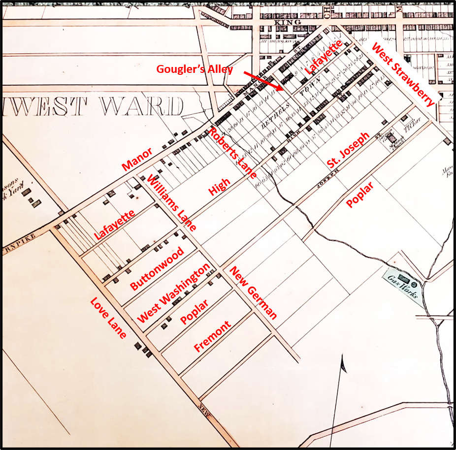
The point is that the names of many of the streets on the Hill have changed over the past 200 years. Specifically, there are 12 main streets in the historic core of Cabbage Hill, which is bounded by Manor, West Strawberry, Fremont, and Fairview. Those 12 streets have had more than 30 different names.

Manor Street, the oldest street on the Hill, was already a well-traveled Native American trading trail when Lancaster was founded in 1729. It was known as the Blue Rock Road in the mid to late 1700s, because it led to an early ferry across the Susquehanna at Blue Rock just south of Washington Boro. In the early 1800s, the southwestern stretch of the street was often called the Manor Turnpike, because of the toll levied on travelers as they crossed the southwestern city limits. Finally, in the mid-1800s, the street became known as Manor Street.
West Strawberry Street is the second oldest street on the Hill, having been a dirt cowpath that marked the southwest edge of central Lancaster when James Hamilton laid out his building lots in 1729. It was known as Slab Alley as late as the 1840s and then in the early 1850s, it became West Strawberry, to distinguish it from its continuation known as East Strawberry on the other side of South Queen Street.
On the opposite end of the historic core of the Hill, Fairview Avenue has been around a long time as a connecting road to South Prince and South Queen at Engleside. From the mid-1800s to 1915, it was called Love Lane, and it has been Fairview Avenue since then. The change of name to Fairview makes sense because it runs along a ridge from which expansive views were possible. I can find no explanation for its first, more amorous, name.
High Street originated with the founding of Bethelstown in 1762 when building lots were laid out on either side of its first two blocks (400 and 500 blocks). By the 1850s, High had been extended southwest to Love Lane, bridging the small stream at the bottom of the hill where New Dorwart is today. Presumably it was called High because of the location of the 400 block on a high point known as Dinah’s Hill.
St. Joseph Street has a complicated naming history. The 400 block of St. Joseph was established in 1850 when St. Joseph Catholic Church was built. At the time the church was built, the street it fronted was called Union Street (not to be confused with today’s Union a few blocks to the southeast, which didn’t exist yet). Then, in the early 1850s, just to make things even more confusing, the street was sometimes referred to as Poplar Street (before today’s Poplar a block over was established). Finally, by the end of the 1850s, the 400 and 500 blocks were renamed St. Joseph. However, at that time, St. Joseph did not extend beyond what is now New Dorwart, and in the meantime the 700 block between Fairview and Laurel had been laid out, and the street there was known as West Washington Street. In the late 1850s, when the two streets were connected by the building of a bridge over the small stream at the future New Dorwart, the entire street became known as St. Joseph.
Now that we’ve brought up Poplar Street……When St. Joseph Church was built in 1850, the small alley behind the church with no houses on it had no name. In the late 1850s, it became Poplar and it was extended to the stream at the bottom of the hill at about the same time the future 700 block of Poplar was laid out on the far side of the stream. In 1870, building lots were laid out on the east side of the 400 block of Poplar. A year later, on the other side of the stream, the 700 block was named Poplar Alley. In the late 1870s, the street was connected with a bridge over the stream, and the whole street was named Poplar Street.
Moving farther east, Fremont Street was established in the late 1850s, starting with the 700 block between Fairview and Laurel. In 1870, when the building lots were laid out along the 400 block of Poplar, so too were building lots on both sides of the 400 block of Fremont. In the early 1870s, the two ends of Fremont were connected by completing the street in between them. Like Love Lane, I don’t know the origin of the name of Fremont Street, although when the street was first laid out in the 1850s, John C. Fremont was a popular national personality who had been an explorer of the West and then the Republican opponent of James Buchanan in the 1856 presidential election.
Now heading back to the west……West Vine Street started as a narrow alley behind the Bethelstown lots that fronted on the southeast side of High in 1762. The first inkling of the street that would become West Vine was born between Fairview and Laurel, where Buttonwood Alley was established in the late 1850s. When the blocks to the northwest up to West Strawberry were established by the 1880s, they were called Buttonwood Street. Buttonwood was renamed West Vine in 1890 as the southwestern continuation of the older West Vine on the other side of West Strawberry.
Next, to a street that cuts across the Hill from the northwest to the southeast—Laurel Street. It was first named in the early 1850s when it was a private lane providing access to the 25-acre property of John Williams between Manor and St. Joseph, and naturally enough it was called Williams Lane. In the 1860s, it was briefly known as New German Street, and then just New Street, and by about 1870, it became known as Laurel Alley, possibly named for local vegetation. From about 1885 to today, it has been Laurel Street.
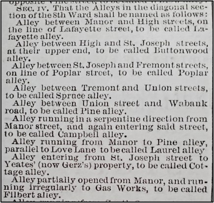
Another northwest-southeast street is Filbert Street. From the establishment of Bethelstown in 1762, there had always been an alley where the first block of Filbert is now. In the late 1850s to early 1860s, it was known locally as Gougler’s Alley, so named because of the house of Jacob and Rebecca Gougler at its intersection with Manor. But it wasn’t until 1871, when the city named or renamed all its alleys, that it became Filbert Alley. About 1890, Filbert Alley was promoted to Filbert Street. Because of irregular property boundaries near the old St. Joseph Cemetery, Filbert had to be offset slightly at St. Joseph Street.
Another alley that eventually grew up to be a street is Lafayette Street. In old Bethelstown, the lots on the southeast side of Manor extended back to meet the lots on the northwest side of High. They met at a narrow alley that would eventually become Lafayette Alley. In the late 1850s, houses had started to be built fronting the alley and the 400 block of the alley was widened to become Lafayette Street. At the same time, the 700 block of Lafayette was established, with a gap in the street where the 500 and 600 blocks would soon be. By about 1890, the two developed ends of the street met in the middle, making one continuous Lafayette Street. The street may have been named for the Lafayette Hotel, which existed on Manor in the 1840s and 1850s, and backed to the alley that would become Lafayette.
All the streets that run from West Strawberry to Fairview had to contend with the small stream that used to run where New Dorwart is today. For most of those streets, the last segments to be built (the 500 and 600 blocks) were the ones nearest the stream. In the 1860s, it appears that a rough path that ran along the stream valley was known as Roberts Lane, likely named for Anthony Roberts who owned land nearby. In the 1880s, the city placed a 6-foot-high brick sewer under the stream, diverted the stream into it, and built New Dorwart on top of it. New Dorwart was first named South Dorwart, a name that faded gradually over time and was finally replaced with New Dorwart about the 1920s. New Dorwart had to be offset at Lafayette, and again at High, because of bends in the now-vanished stream around which early houses had to be built.
Now, if your eyes have not yet completely glazed over with all these street names………In honor of this month’s Valentine’s Day, if anybody has any ideas on why Fairview Avenue was originally called Love Lane, please comment with your ideas!