Applications are now open for Lancaster City’s Love Your Block, Park Adoption Mini-Grants, and the Neighborhood Leaders Academy!
Want to clean up your stretch of road? Have a project idea
on how to fix a local issue? Love Your Block provides funds of $500-$2000 for
community-led projects addressing issues surround litter, urban blight, and
façade improvements. The projects must affect the whole block and require a
coalition of at least 5 neighbors from 3 different households. Americorps
VISTAS, Renee and Christian, will assist with project management, scheduling,
budgeting and implementation, so don’t worry about needing experience. Find
more information about Love Your Block, along with an online application here.
Additionally, Lancaster has a Park Adoption grant that also
provides $500-$2000 for projects improving and expanding the usability of local
parks or green spaces. Find more information about Park Adoption, along with an
online application here.
Applications for both grants are due by March 20, 2020. They
can be submitted online or, physical versions can be mailed to City Hall at 120
N. Duke Street, Lancaster, PA.
The Neighborhood Leaders Academy is open for applications as well! The program is a six-month training and grant program for community leaders to imagine, develop, test and realize projects that build community and provide positive outcomes. The program will empower leaders in all Lancaster neighborhoods to encourage one another, identify problems, plan projects to beautify the neighborhood and remedy issues, and celebrate the community and each other. Applications are due March 27th, 2020. For more information click here.
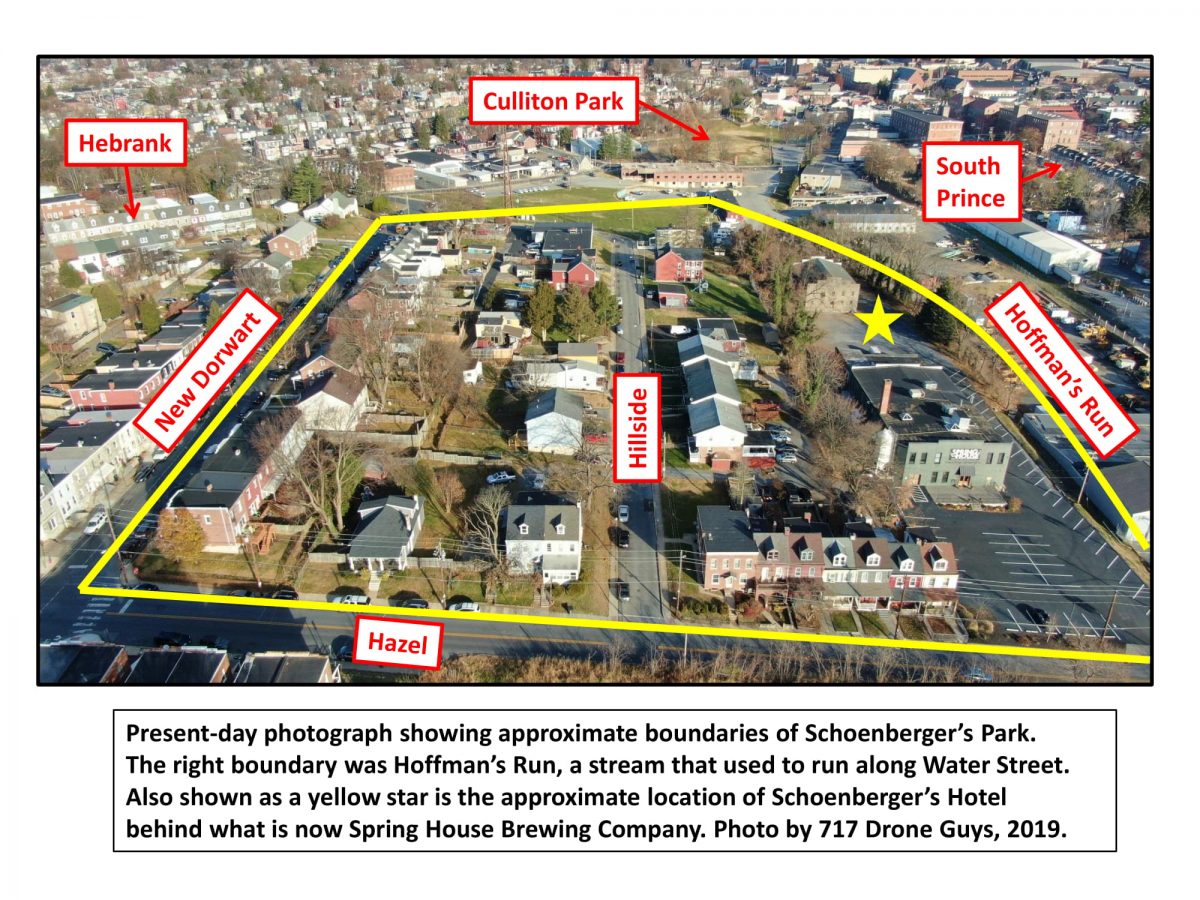
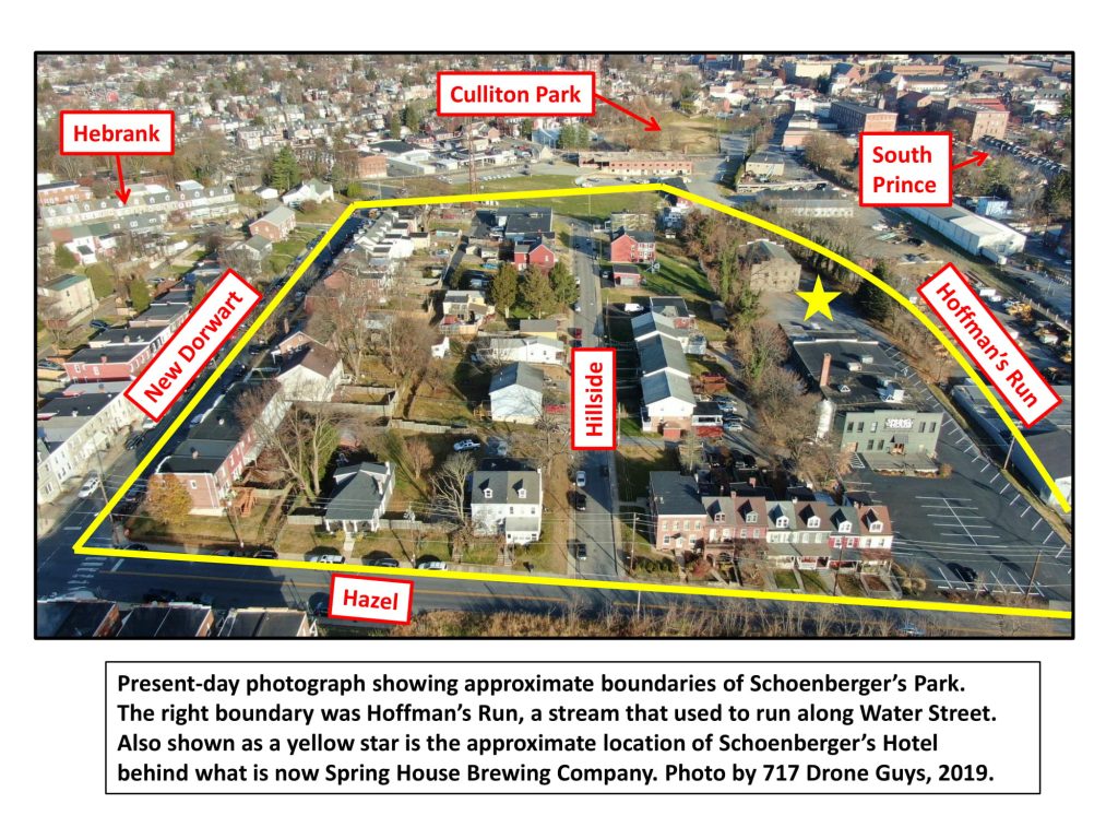
Before
Farnum (now Culliton), Rodney, Brandon, and Crystal Parks in southwest
Lancaster City, and before larger regional parks such as Rocky Springs, People’s,
and Maple Grove, there was a large park known as Schoenberger’s Park on the
eastern edge of Cabbage Hill. It was a popular place for various family and social
gatherings in the 1870s and 1880s. Unfortunately, it also was home to a gang that
plagued the park and all of southern Lancaster for many years.
William
August Schoenberger was three years old in 1851 when he immigrated to Lancaster
from Baden-Wurttemberg, Germany, with his parents, August and Catharine
Schoenberger. His father was a wealthy brewer, and William learned the brewing
trade working in his father’s saloon on the east side of North Queen Street above
Orange.
In 1869, when
William was 21, he purchased a little more than nine acres of rugged land on
the eastern slope of Cabbage Hill just west of Hoffman’s Run. Hoffman’s Run was
a stream that ran north-south along Water Street until its last surviving reach
was buried in a sewer in the late 1800s. The nine acres that Schoenberger
bought was a mixture of meadows and woods, and was bounded on the west by what
is now the southern leg of New Dorwart Street, on the north by the old gas works,
on the east by Hoffman’s Run, and on the south by Hazel Street.
By the early
1870s, Schoenberger had built a two-story brick hotel with six rooms and a saloon,
which became known as Schoenberger’s Hotel. The hotel was on a level spot on a slight
rise on the west bank of Hoffman’s Run, behind what is now the Spring House
Brewing Company. A boarded-up, cinder-block warehouse stands near the site now.
Schoenberger built a large beer vault that was used to store his beer, as well
as the beer of other Lancaster breweries, most notably Wacker Brewery. The beer
vault was 68 feet long, 20 feet wide, and 14 feet high, with an arched ceiling.
Schoenberger left the rest of the land in meadows and woods, creating a
park-like setting that would attract the residents of Lancaster.
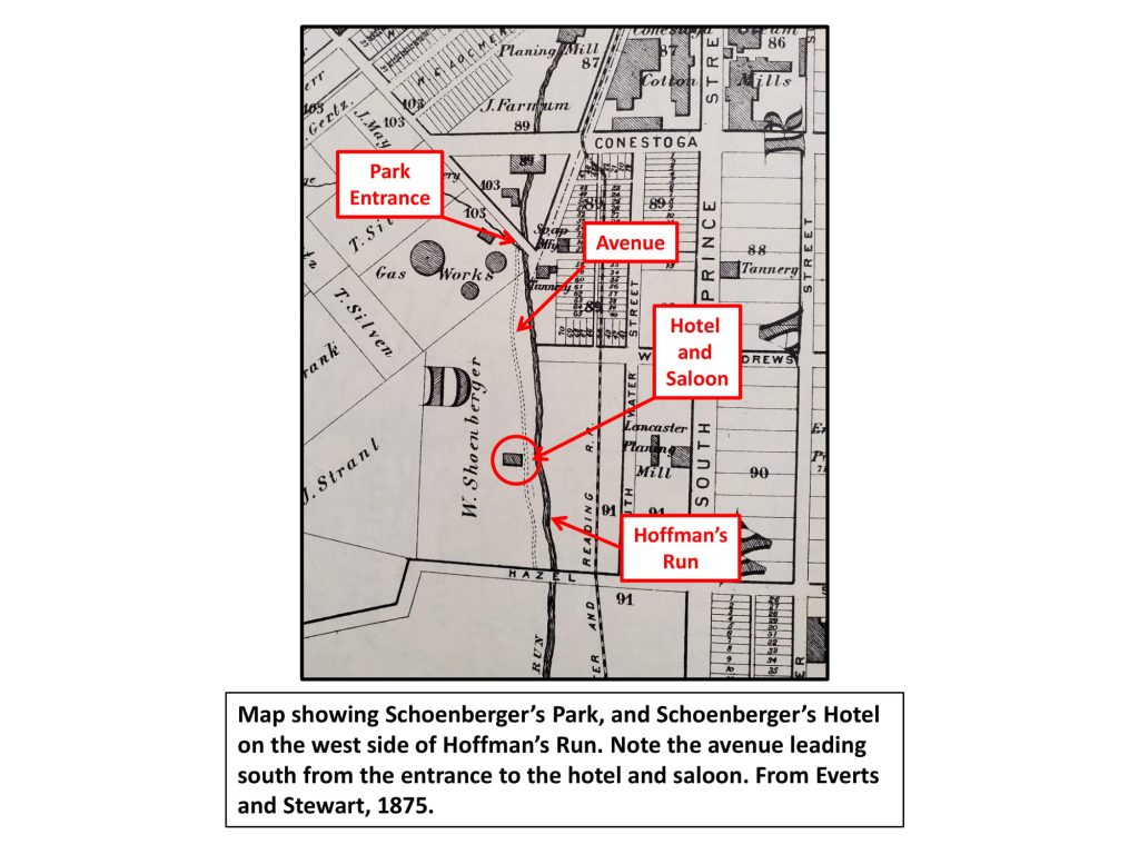
The entrance
to Schoenberger’s Park was a bridge over Hoffman’s Run about 200 feet south of
Conestoga Street, due south of what is now Conlin Field in Culliton Park. An
avenue shaded by planted trees wound its way through a meadow along the west
bank of Hoffman’s Run and then up a slight rise to the hotel. The hotel, which
had gardens of flowers planted around it, was on the edge of the more rugged,
steep, forested part of the park to the west. A wooden dance floor encircled a
large tree near the hotel. An old-timer, Charles A. Kirchner, recalled in 1938
that “people went for walks and picnics in the park”, and that it was “a
beautiful place with grass and trees—some fruit trees…”
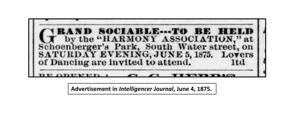
In addition
to a place for people to take walks and enjoy picnics, the park quickly became
a popular spot for larger gatherings. In the 1870s, various clubs and other
organizations held events there. Many of the events were “sociables” that
involved music and dancing, organized by groups such as the Eighth Ward Club,
the Sun Steam Fire Engine and Hose Company No. 1 (William Schoenberger was a member),
and the Keystone Drum Corps. Daniel Clemmens’ City Band, the Fiddlers Three,
and Godfried Ripple’s String Band were some of the providers of dance music.
Other events included political rallies (the Meadow Reform Club of the Fourth
Ward), pigeon shoots with turkeys as prizes, and Temperance Mass Meetings. One
well-attended event was an ox roast in honor of the visiting Allentown Cornet
Band.
William
Schoenberger was deep in debt by 1876, and his park, along with his hotel, had
to be sold at auction to repay his debts. Benjamin Greider bought the property
at a sheriff’s sale. Schoenberger moved back in with his widowed mother at his
late father’s saloon on North Queen and helped run the saloon there for a few
years. Eventually, he had a long career as a bank messenger for the Lancaster
Trust Company, dying at the age of 73 in 1922. The park continued to be known
as Schoenberger’s Park for another 15 years after Schoenberger last owned it,
but the hotel became known as Snyder’s Saloon when Greider brought on Michael
Snyder, and then Michael’s son Adam, to run it, which they did into the late
1880s.
The park and
its hotel had a good run in the 1870s and 1880s, but the combination of wayward
young men, a secluded wooded setting, and beer, often led to violence and criminal
activities. As early as 1875, drunken fights broke out and people were injured,
thieves broke into the beer vault and stole kegs, and passersby were harassed
and assaulted. The saloonkeepers didn’t always help their cause, as both
Schoenberger and the Snyders were charged with selling beer on Sundays, which
was against the law.
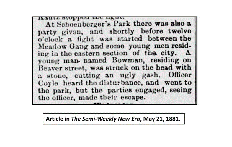
Things got
even worse with the rise of the Meadow Gang in the late 1870s. A group of
several dozen young troublemakers took advantage of the relative remoteness of
the park to make it their hangout. By the mid-1880s, incidents were happening
with increasing frequency. The city police could spare little manpower to the
“suburbs” of southern Lancaster, but they tried to respond when they could. Often
when the police were summoned, by the time they got to Schoenberger’s Park, the
Meadow Gang was long gone.
Some of the
nefarious activities of the Meadow Gang included: Saloonkeeper Michael Snyder was injured when
hit by a chair in a fight with the Meadow Gang. A large amount of lead was
stolen by the Meadow Gang from a plumbing shop on South Queen. A young man was
seriously injured in a fight between the Meadow Gang and some young men from
the Schiffler Fire Company. The Meadow Gang threatened to kill a man who had
leased part of the park for grazing his cattle. Five members of the Meadow Gang
were arrested for breaking into a railroad car near Hazel. The Meadow Gang ran
a plow through a nearby field of tobacco and potatoes, damaging the crops.
One particularly
nasty incident caused an uproar among the people of the city, and probably had
something to do with the decline of the park. In the summer of 1885, a young
girl 16 or 17 years of age claimed to have escaped from the Meadow Gang after
having been held by them for two months in the area of the park. She claimed
that she had been poorly fed and assaulted numerous times. Subsequent
investigation into her claims revealed some inconsistencies in her story, to
the point that it was not clear exactly what had actually happened. However,
the damage had been done, the public was outraged, and the reputation of
Schoenberger’s Park suffered.
The Meadow Gang
was active in the park and the rest of southern Lancaster well into the early
1900s, with some of the same men staying active in the gang for more than 20
years. Even as late as the early 1920s, the Meadow Gang was still causing sporadic
trouble. By the late 1920s, however, the gang disappeared from the scene. Strangely,
as time passed, memories of the Meadow Gang seemed to soften, with their less
severe antics remembered somewhat fondly and their more serious crimes downplayed.
In 1931, one
Lancaster newspaper even did a feature story on the old Meadow Gang, with a
headline, “Meadow Gang 1880s Flaming Youth”, comparing them to the harmlessly rowdy
youth of the Roaring Twenties. In the article, an original member of the Meadow
Gang was interviewed and claimed that the more serious crimes attributed to the
gang had not actually been committed by its members. According to him, they
were just young men acting out, with no serious offenses to their name. True or
not, the Meadow Gang was instrumental in changing the park from a nice place to
visit to a dangerous adventure.
The park was purchased by Stephen Owens in 1889, and a small limestone quarry was opened on its western edge, on the lower slope near the hotel/saloon. Owens then sold part of the park to the Lancaster Gas Light and Fuel Company in 1895 to expand the gas plant. By the mid-1890s, the hotel was gone, and much of the land was subdivided for building lots. Streets were laid out and houses began to be built on the slope above where the hotel had been. The 25-year run of Schoenberger’s Park was over. By then, new city parks had been established, and memories of Schoenberger’s Park began to fade.
Today, the
site where bands once played and people once danced, and where the Meadow Gang
once roamed, has become the home of Spring House Brewing Company and the first
blocks of New Dorwart and Hillside off Hazel. It’s hard to visualize now, but
there used to be a “beautiful place with grass and trees” called Schoenberger’s
Park in southwest Lancaster more than 125 years ago.
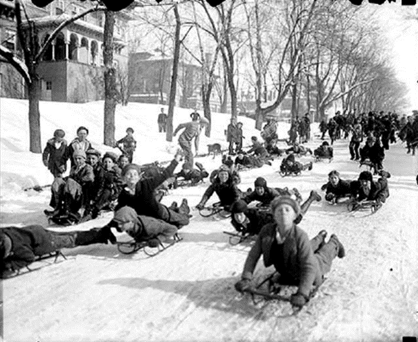
“The narrow, icy path in the middle of the long and very steep
grade was as smooth as glass and the sleds dashed down the icy incline at a
speed which nearly took one’s breath.” (January 1892)
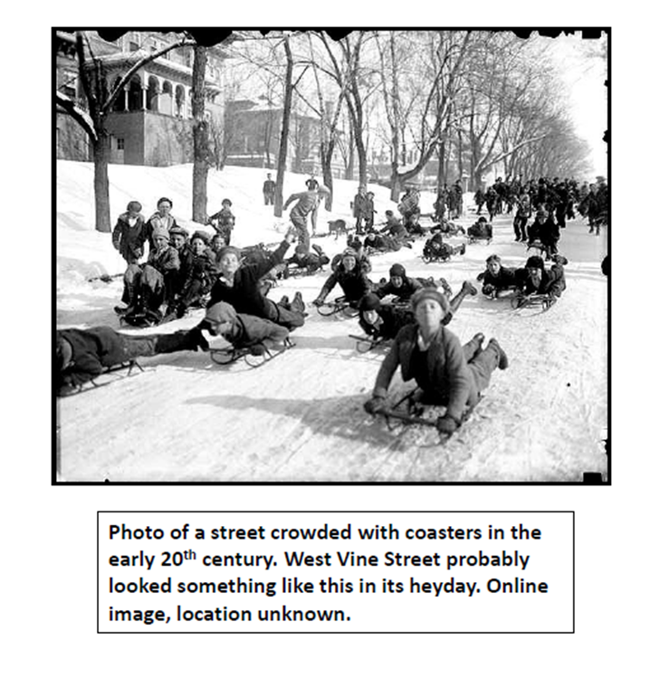
Coasting, or sledding as many of us know it today, was once a major
form of entertainment during winters in Lancaster, drawing both hundreds of
participants as well as thousands of spectators. It was mostly done in the
evening, using a variety of sled types, on all the hilliest streets in the
city. The steepest and most dangerous coasting spot, and therefore the most
popular among Lancaster’s more adventurous young people, was Dinah’s Hill on
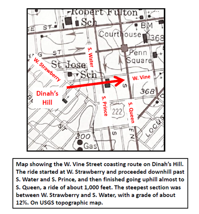
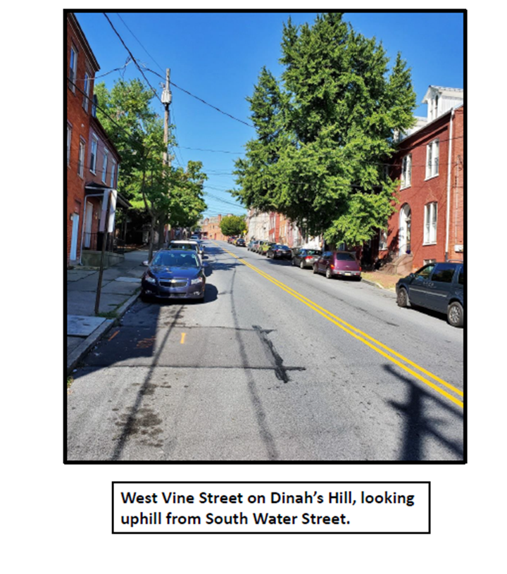
West Vine Street, on the northeast edge of Cabbage Hill.
Dinah’s Hill, named for Dinah McIntire, an old African-American
fortune teller who lived there, is the northernmost of Cabbage Hill’s two
hills, with its highest point along West Strawberry Street between Lafayette
and West Vine Streets. West Vine drops steeply from West Strawberry to South
Water, at a grade of about 12%, which makes it an ideal street for fast
coasting, especially when the snow gets packed down and becomes like ice. It’s
no wonder that Dinah’s Hill was the hill of choice for Lancaster’s young
coasters, and for the many spectators who came to watch them risk their lives
and limbs.
Coasting down West Vine was a dangerous sport. Lancaster’s
newspapers carried numerous stories of injured coasters every winter from the
early 1870s to the late 1920s. The injuries ranged from bruises to deep cuts to
concussions to broken bones. More than once, particularly violent accidents
left young coasters unconscious and word would spread that they had been
killed. One young coaster actually did die from his injuries in 1875. Doctors
in the vicinity of Dinah’s Hill were kept busy on the evenings following
snowfalls and ice storms.
The dangers of coasting on Dinah’s Hill were several. The most
serious risk came at the intersections of streets that crossed West Vine, such
as Arch, Water, and Prince. Wagons and carriages, and later cars and trucks,
crossing West Vine often were the cause of coasting accidents. Pedestrians
crossing West Vine also were hit by coasters. But the most serious crossing
risk was at Water Street, where trains of the Quarryville Railroad would rumble
across West Vine. Other obstacles were lampposts, telegraph poles, trees, and
other coasters. Following a spill, the riders strewn across the street were at
risk of being run over by the next sled coming down.
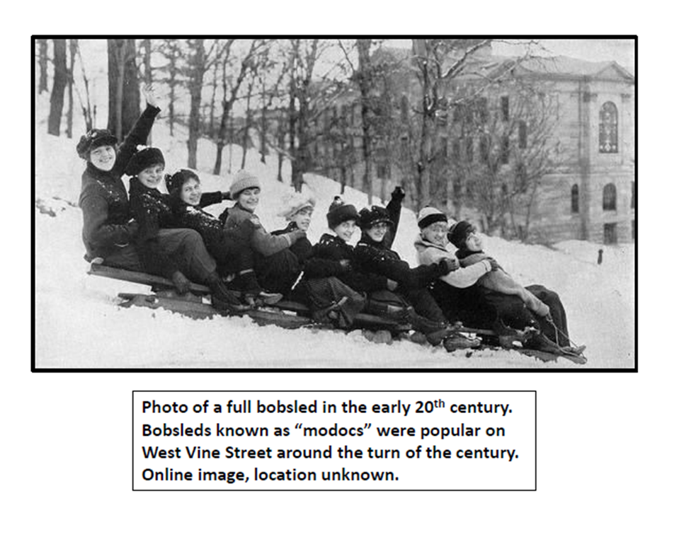
A wide variety of sleds were used. Many coasters used small one-
or two-person bent-wood sleds with iron rails, but they were sometimes
outnumbered by larger sleds such as toboggans and bobsleds. These longer sleds
often carried six, and as many as 12-15, riders. One particularly large
toboggan-like sled reportedly used in the southeast part of the city was
22 feet long and carried 30 riders. A popular form of the longer sleds
used in Lancaster was the “modoc”, which could carry as many as a dozen
riders.
On evenings with favorable coasting weather, more than 500
spectators would line West Vine between Strawberry and Prince. On at least one
occasion, a crowd of 2,000 onlookers was reported. On evenings like these,
coasting was especially dangerous due to the number of people who might be
standing and walking along and on the street. Pedestrian involvement in
accidents was not uncommon.
Young people being young people, there was usually some
competition to see who could go the fastest, and races would be staged, adding
to the risk on a narrow street. The slight rise in Water Street where the
railroad tracks were located provided a chance for a sudden bump and jump for
the most daring coasters. At times, coasters would turn around after reaching
Queen and start coasting back down to Water, against the flow of sled traffic,
but the danger of head-on collisions was too high and the police would usually
prohibit this practice.
There was a constant struggle between coasters and city
authorities to maintain some sort of balance between entertainment and safety.
Several times, after particularly close calls or serious injuries, the mayor
would impose a curfew, have ashes spread on the icy roads, or temporarily close
down coasting altogether. But each year the coasters would be back and the
struggle would be renewed. It was difficult to police hundreds of young people
on numerous hills throughout the city over several hours each evening.
Residents who were affected by the coasting, as well as businesses and the
railroad, complained each year until the mayor had to get involved once
again.
The newspapers seem to have covered the coasting scene with a bit
of a sensationalistic approach. The accidents were usually the reason for the
articles, and the headlines were almost always about the injuries. One can
picture eager reporters near the bottom of the hill rushing out into the street
to accident scenes to record the names of the injured and their injuries. And
the language used in the newspaper articles was typically breathless, if not
sometimes downright lurid.
Here are a few snippets from newspapers that provide a flavor of
the coasting phenomenon on Dinah’s Hill in its heyday from the 1870s to the
1920s, starting with the earliest newspaper story I could find:
“From time immemorial, ‘Dinah’s Hill’, located in the Southern
part of this city, has been quite a resort, in sledding seasons, for juveniles.
Its length and gradual declivity gives it preponderance, and hence the rush.
Last evening the hill was crowded with smiling urchins, male and female.” (January 1871)
“…on some nights the number of persons who came to ‘Dinah’s Hill’
merely to look on, ran into the thousands! It was one of the “sights of the
town” and afforded more thrills per minute to onlookers or participants in the
fun than any boxing match…” (April 1929)
“A collision was then inevitable, and the sled struck the team (of
horses) with terrific force. Both boys were hurled to the ground, and by many
believed to be killed. Both were unconscious and lay bleeding in the street.” (December 1902)
”A very painful accident occurred last night to a young man of
about twenty years of age, named Martin Metzroth, while coasting down Dinah’s
Hill. By some means the sled ran against a tree, striking the young man’s knee
with great force against the latter, and knocking the knee-cap off.” (January 1873)
“…four boys on a sled shooting down ‘Dinah’s Hill’ almost ran into a
Quarryville engine. They escaped by throwing themselves off. The driving wheel
hit their sled and broke it.” (January 1903)
“John Kane, aged 12 years, and son of Patrick Kane, residing on
West Vine Street, met with a serious accident on Tuesday evening. While coasting
on Dinah’s Hill, he was run into by a sleigh and his heel was struck and badly
bruised. Dr. A.J. Herr dressed the wound, but the boy may be permanently
crippled.” (December
1880)
“We have heard of many strange accidents. We know of cases of
boys, who, in coasting on Dinah’s Hill, have gone under railroad trains without
injury. Others have hit automobiles, or, in avoiding them, they have struck
trees and pedestrians.” (January 1925)
“…Mrs. R. Frank….stepped directly into the path of a bob-sled speeding down
Dinah’s Hill with over a dozen boys and girls aboard. The woman was knocked
down and sustained lacerations of the forehead and chin.” (January 1925)
“…one of the coasters, Francis Suter, who, in coming down Dinah’s
Hill at a fearful rate of speed, ran his sled and his head against a lamp-post
with so much force, that it is feared he will lose one of his eyes.” (February 1872)
“…a badly-frightened motorist reported to police that he had narrowly
escaped colliding with a big bob-sled that had streaked across South Prince
Street right in front of his car. After the close shave, he said, he stopped
the car and was immediately surrounded by a group of angry sledders, who
claimed he hadn’t sounded his horn.” (February 1924)
“…several yards before the crossing, the locomotive hove into view.
The youths desperately rolled off the sled, tumbling over and over and picking
up a variety of ice burns as their vehicle slammed into the wheels of the train
and was ground to bits.” (January 1903)
“While Oscar Erb, aged ten years, was coasting on Dinah’s Hill on
Thursday evening, he fell off his sled and the sleigh following him, struck the
lad. His head was cut open, and he was otherwise bruised about the body.” (February 1914)
“Yesterday afternoon about 5 o’clock as three boys were descending
Dinah’s Hill on a sled, they came in collision with a six-horse team that was
coming up Prince Street. The sled struck the lead horse and frightened him,
rendering him for a moment unmanageable. The boys fell headlong under the
horse’s feet, and were in imminent danger of being trampled to death by their
hoofs, or crushed beneath the wheels of the heavy wagon. Luckily they escaped
unhurt, but the sled was smashed all to pieces.” (February 1873)
“John Kress, the young man who had his leg shattered several weeks ago while coasting on Dinah’s Hill, and who has suffered terribly ever since the accident, died of lock-jaw about 5 o’clock on Saturday afternoon.” (February 1875)
After the 1920s, the increasing number of cars driving on the streets and parked along the curbs, as well as more and more safety precautions on the part of city officials, put a gradual end to the glory days of street coasting in Lancaster. Today, coasting doesn’t seem to be as popular, and most of those who do go coasting do so at parks and other open areas, rather than on city streets. For many years, though, the youth of Lancaster had their fun, and risked their lives, coasting down the best hill in the city—West Vine Street on Dinah’s Hill.
St. Joseph Catholic Church was founded in 1849, when a group of German parishioners from St. Mary’s Catholic Church convinced the Archdiocese of Philadelphia that a second Catholic church was needed in Lancaster to serve the growing German population on Cabbage Hill. The new church quickly became the spiritual, cultural, and social hub of the Hill, roles that it continues to fill today. Here, in honor of the church’s 170th anniversary, are nine factoids about the church’s early years, some of which may be familiar and others which may not.
Lot purchase: The lot on which St. Joseph Church was built was purchased for $260 from Casper Hauck on January 8, 1850, by Bishop Francis Patrick Kenrick of the Diocese of Philadelphia, on behalf of “the German Catholics of the City of Lancaster”. The lot, which was on the southeast slope of Dinah’s Hill, was 137 feet wide and 191 feet long, and had no buildings on it. In fact, at the time the lot was purchased, there were no buildings at all on the first two blocks of the streets that would soon become West Vine, St. Joseph, Poplar, and Fremont. The lot and the land surrounding it were pastures.
Church and street names: The original St. Joseph Church, the first ethnic Catholic church in the U.S., was built in 1850. Although it was St. Joseph Church from day one, it was commonly known around Lancaster as the “German Catholic Church” for its first few years. Also, when the church was built in 1850, the street on which it fronted was known as Union Street (not to be confused with today’s Union Street, which didn’t yet exist in 1850). Then, for a brief time, the street appears to have been known as West Washington Street. Finally, by the mid-1850s, at about the time the church became commonly known as St. Joseph Church, the street became St. Joseph Street.
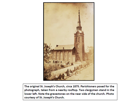
First building: The original church was 50 feet wide
and 105 feet deep, and it seated about 350 people. Its cornerstone was laid in
May 1850, it went under roof in the fall of 1850, and it was consecrated in
December 1850. It was made of brick, had a slate roof, and had five tall
windows on each long side. There was a basement for the school and society
meetings, and a small tower at the front entrance. By 1852, the tower had been
built taller and a wooden spire had been added. By 1854, the finishing touches
were completed—adding pews, finishing the basement, installing an organ, adding
the altar, installing bells in the tower, and adding a clock with four faces in
the tower.
Pastor conflict: St. Joseph’s had five pastors in its
first five years. The third pastor was John Dudas, a young Hungarian priest who
turned out to be a controversial choice. He had only served about five months
when his pastoral assignment was revoked by the Diocese of Philadelphia because
he had taken sides in political matters and had consorted a little too freely
with Lutherans. In March 1852, he was asked to vacate the rectory next to the
church, but refused to do so until the church paid him some money he was owed.
Dudas then refused to open the church for a funeral, and when he left the
locked church and went downtown for breakfast, a group of church founders broke
into the building and threw his belongings out on the street. Dudas pressed
charges against the offending parishioners but a verdict of not guilty was
delivered. He quickly left his post at St. Joseph’s, and within a few years he
had become a pastor of a Christian congregation in Constantinople, Turkey.
Cemetery: The lot purchased in 1850 did not
include the cemetery that is now southwest of the church. Early burials took
place in a narrow strip along the northeast side of the church where the
driveway to the left of the church is today. The current cemetery lot next to
the rectory seems to have been acquired by the late 1850s. The early graves on
the northeast side of the church were moved to the larger cemetery on the
southwest side in 1881 to make room for a new school building.
Political dispute: The German immigrants on the Hill had always been staunch Democrats, and were not shy about voicing their views on political matters. In early July 1863, just days after the Battle of Gettysburg, President Lincoln, a Republican, declared a new military draft to replenish the Union troops. Many members of St. Joseph Church, including a small group of about a dozen vociferous German women, disagreed with the draft and a large demonstration took place at the Courthouse on July 16, as draftees were about to start signing up. The demonstration was led by the German women, and a major riot was just barely averted. In his sermon the following Sunday, Pastor Schwartz of St. Joseph’s admonished his parishioners, especially the women who were “a disgrace to their womanhood”, making it known that good citizens of this country must obey its laws whether they agree with them or not.
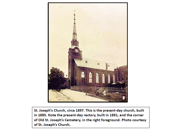
Unique construction approach: By the early to mid-1880s, the
growing number of St. Joseph’s parishioners necessitated a larger church. To
avoid missing any Masses, a clever approach was taken to replace the old
smaller church with a new larger one. The new church was to be 15 wider, 54
feet longer, and significantly taller than the old one. The church leaders
decided to build the new church around the old one, enabling the congregation
to continue to have Mass in the old church while the new one was being built.
When the external structure of the new church was completed, the basement of
the old church was set up for Mass, and the congregation then worshipped in the
basement while the old church was dismantled and taken out from inside the new
one. When the old church had been removed, Mass was held in the new church
while the finishing touches were completed on the interior. Even the extensive
painting and frescoing in the upper reaches inside the new church did not
prevent the use of the church for Mass. Scaffolding that would have interfered
with Mass was not required, as the artisans doing the high decorative work did
so from scaffolds hung from ropes through holes in the roof. When the new
church was completed in 1885, the only vestige of the old church that remained
was the tower and spire, and even that had been modified a bit to harmonize
better with the taller roof.
The builders: The new 1885 St. Joseph Church building, which seated more than 1,100 people, was designed by William Shickel, New York City. The principal contractor for the construction of the building and the finishing of the interior was Dionysius Rapp. John Mentzer and William Westman supplied the stone. The stone-cutting was done by Zeltman & Cron. Krieg & Streiner did the stone steps. Henry Drachbar laid the bricks and the lumber was provided by Sener & Sons and Baumgardner, Eberman, and Co. William Wohlsen provided the millwork. The plumbing was done by L.H. Bachler, and George M. Steinman & Co. provided the hardware. Jerome Dosch & Son did the plastering and Leonard Yeager did the painting.
German craftsmen: Tradition has it that the craftsmen and artisans who built the larger St. Joseph Church in the mid-1880s were German immigrants who lived on the Hill. This is mostly true. Indeed, nearly all of the principal contractors and companies were of German heritage, and about half of them had been born in Germany. Dionysius Rapp, Krieg & Streiner, Jerome Dosch & Son, and Leonard Yeager had their businesses on the Hill, while the remaining contractors were from other parts of Lancaster City. Most of the laborers on the contractors’ crews were no doubt Germans from the Hill. The gravestone of superintendent Dionysius Rapp and his wife Rosina still stands near Poplar Street in Old St. Joseph’s Cemetery.
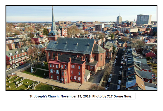
There is
much more to the story of this venerable old church on the Hill. Another 135
years of history has happened since the mid-1880s when the present-day church
was built. The gravestones of the Old St. Joseph Cemetery adjacent to the
church represent many interesting stories of the church’s founders, some of
which may be explored in future posts on this site.
As many of you know, St. Joseph Church has willingly allowed SoWe to occupy office space in one of its buildings, and to hold monthly Board meetings in another of its buildings. Happy 170th anniversary from SoWe to the centerpiece of Cabbage Hill!
We are all familiar with stories of immigrants who arrived
in America with nothing and ended up being very successful. In fact, Cabbage
Hill has had its share of German immigrants who were very successful through
some combination of talent, ambition, hard work, perseverance, and luck. But no
less important to the progress of the Hill were the many hundreds of German
immigrants who struggled for years just to get by.
The great majority of German immigrants to the Hill in the
late 19th and early 20th centuries were only able to
achieve modest success, and for many, the fruits of their struggles only
accrued to their children or grandchildren, who often succeeded because of the
foundation laid by their parents’ and grandparents’ struggles. The small
successes of these struggling immigrants, in aggregate, helped build a strong,
resilient neighborhood. Their stories, as painful as some of them are, are an
important part of the history of Cabbage Hill.
One such story is that of Georg Friedrich Mosser (George
Moser), who arrived in New York City from Bavaria, Germany, on May 8, 1906. He
was a single, 23-year-old laborer with $25 in his pocket. He was quickly processed
through Ellis Island and got on a train to Lancaster, where he came to meet up with
his friend Frank Bernauer on St. Joseph Street. George got a job as a laborer
at a brewery, and started what he hoped would be a successful life in America.
Back in Bavaria, George had fathered two children (Theresa
and Alphonse) with Rosa Reitberger, a woman five years his senior, who also had
relatives and friends who had immigrated to Lancaster. A year later, in 1907,
Rosa followed George to Lancaster, leaving her two young children with her
widowed mother in Bavaria. On November 19, 1907, George Moser and Rosa
Reitberger were married at St. Joseph’s Catholic Church.
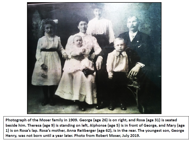
In 1909, as they were getting settled in their new life on
the Hill, George and Rosa brought daughter Theresa and son Alphonse to
Lancaster from Germany, along with Rosa’s mother, Anna. One month after Anna,
Theresa, and Alphonse arrived in 1909, George and Rosa bought a two-story frame
house at 662 Poplar Street for $1,050. George and Rosa had two more children
(Mary and George Henry) in 1908 and 1910. The Moser family unit had been
established. Things were going according to plan.
George became an American citizen in 1912, and for the next
eight years, he worked in various capacities at breweries in Lancaster,
including laborer, brewer, and delivery wagon driver. He was arrested but found
not guilty of assaulting a strikebreaker at Sprenger Brewery. He was elected
vice-president of the Brewery Workers labor organization. By 1920, he was
working at Empire Brewery on Locust Street.
Although George was having some success in the brewery
business, he and Rosa had to borrow money several times in the 1910s, and each
time they were unable to keep up with payments on the resulting debts. They
were sued by their creditors and were just barely keeping up with the required
payback plans handed down by judges in civil court.
Then, Prohibition took effect in January 1920, and it became
illegal to make, sell, or transport alcoholic beverages. The Empire Brewery
closed and George’s income from the brewery industry was suddenly gone. Out of
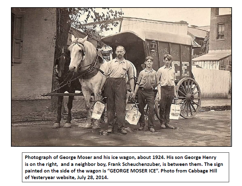
necessity, George started his own business—peddling ice. He had a wagon and two
horses (Jim and Dick) to pull it, and he and his 16-year-old son Alphonse began
selling blocks of ice around Lancaster. His was one of eighteen ice-peddling operations
delivering ice from the Lancaster Ice Manufacturing Company at Engleside. He ran
his ice business out of the rear of the Moser house at 662 Poplar. To augment
the family income, daughter Theresa worked as a weaver at the Conestoga Steam
Cotton Mills on South Prince Street.
The ice business must have seemed promising. In 1921, George
and Rosa purchased another two-story frame house and three lots at 615 Fremont
Street for $1,500. They likely had to borrow money to make the purchase, but
they must have thought the investment would pay off in the long run. When their
daughter Theresa married Charles Kirchner in 1922, the new couple moved into
the house on Fremont. George and Rosa continued to live with the rest of their
family at 662 Poplar, and George and his son Alphonse continued to peddle ice.
Soon, the youngest son, George Henry, was old enough to help in the ice
business as well. Alphonse also worked for a while at the Conestoga Steam
Cotton Mills, and daughter Mary took a job at the Follmer-Clogg silk mill on
Manor Street to help out.
Despite all the hard work, the Mosers still struggled
financially. Several times between 1920 and 1925, they were again unable to pay
back various loans, and they were taken to civil court and ordered to pay off
the loans, which they seem to have somehow done. Then, in 1924, their son
Alphonse left Lancaster, and George lost a key pair of hands to help in the ice
business. Again, out of financial necessity, George and Rosa decided to start a
second new business—a café.
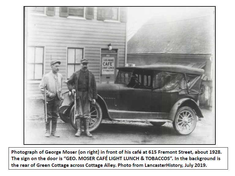
By 1927, they had established a café in the first floor of
their house at 615 Fremont, and sold “light lunch and tobaccos”, as their sign
on the front door stated. Daughter Theresa and her husband Charles continued
living upstairs, and an extra room was rented to boarders. George brought on
Philip Kirchner, a cousin of son-in-law Charles, to run the day-to-day café
business. When Theresa and Charles moved out of the upstairs living quarters,
George and Rosa rented out their rooms as well and the café became known as a
hotel. George continued to peddle ice, with his son George Henry’s help, and daughter
Mary continued to work at the silk mill. It seemed that George and Rosa and
their family were finally going to be able to make ends meet, but things were
about to take a turn for the worse.
George had purchased a touring car and in April 1927, he had
a serious accident on Lincoln Highway East near Bridgeport. His car was
demolished and he was taken to the hospital with what was feared to be a
fractured skull, a broken jaw, and broken ribs. Fortunately, his injuries
turned out to be only severe cuts and bruises. In October 1927, he had another
accident in which his car was broadsided and overturned at the intersection of
Manor and Filbert Streets. Again, he was not badly injured. Adding to the
family’s problems, George, who had been a drinker for a long time, began to
drink too much. Prohibition was in full effect, but George seemed to be able to
acquire illegal beverages. In the same year, 1927, that he had his two car
accidents, he was cited for being “drunk and running a car”.
Then, in December 1928, the police raided the café/hotel on
Fremont and confiscated three cases of “high-powered beer”. It seems the Moser establishment
had become one of the numerous speak-easies in Lancaster, and that George was manufacturing
illegal beer for sale to his café customers. As a result of the raid, George
was charged with violating the Prohibition liquor law, a crime that often carried
a large fine and substantial jail time. A mid-January trial date was set, and George
was released on $500 bail put up by his close friend and neighbor on Poplar,
Albert Scheuchenzuber. But just two weeks before the case made it to trial,
George suddenly died on January 3, 1929, at the young age of 45. The doctor
attending him attributed his death to chronic alcoholism complicated by
influenza.
Following George’s death, Rosa tried to make a go of the
café and hotel business, but within a few years, the business had closed. Their
son Alphonse, who had come back to Lancaster after his father’s death, teamed
up with his younger brother George Henry to keep the ice business going, moving
it from 662 Poplar to where Alphonse was living at 615 Fremont. This last of
the Moser family’s two business enterprises lasted until the early 1940s.
In the less than 25 years since George Moser had immigrated
to Lancaster, he had accomplished a lot. He had gotten married, bought two
houses, raised four children, worked in the brewing industry, and started two
businesses of his own. On the other hand, he had failed to repay loans, violated
the liquor laws, and become addicted to alcohol. Although George’s immigrant
experience was certainly not an unqualified success, he had accomplished enough
to allow his four children to succeed. All four of the children of George and
Rosa Moser got married and all four owned their own houses on the Hill by the
1940s.
George Moser’s story, with different details, has been
repeated many hundreds of times over the years on Cabbage Hill, and the true history
of the Hill cannot be told without those stories. Today, new immigrant families
are creating their own stories of struggling to succeed on the Hill. A much
more diverse group of immigrants are now calling the Hill their first American
home, but their language, housing, and employment struggles are not all that
different from those of German immigrants more than 100 years ago. SoWe is helping
today’s new immigrants overcome their struggles, by trying to create a neighborhood
that is safe, clean, and welcoming, and by providing services that facilitate
their transition into their new community on the Hill.
Postscript: This
story of George Moser and his family was prompted by correspondence with Robert
Moser, Ph.D., former Executive Director of Catholic Charities, Diocese of San
Diego. Bob, who was raised on Manor Street , contacted me after reading a
history piece on the SoWe website, and expressed an interest in learning more
about his grandfather George Moser’s business enterprises on the Hill. I thank
him for allowing me to present this story of his grandfather’s immigrant
experience. Appropriately enough, Bob’s position with the Diocese of San Diego
involved helping immigrants—in this case refugees—start new lives in
California.
The title of the 1992 film, “A River Runs Through It”, once
applied to Cabbage Hill. Up until the early 1880s, a stream flowed where New
Dorwart Street is today. It was a tributary to a larger stream that drained a
watershed that covered about two-thirds of Lancaster City. The entire stream
system has long since been buried in sewers that run under some of the major
streets of the city.
When Lancaster was founded in 1729, James Hamilton named one
of its north-south streets Water Street, and with good reason. A stream ran
from near the intersection of West Walnut and North Arch in northwest
Lancaster, southward down most of Water to Engleside, where it emptied into the
Conestoga River. The stream was called Roaring Brook in the mid-1700s; Bethel’s
Run from the late 1700s to early 1800s; Hoffman’s Run from the early 1800s to
late 1800s; and finally Gas House Run around the turn of the 20th
century, before it completely vanished.
There were several tributaries to the larger stream that
flowed down Water, including one along West King between Christ Lutheran Church
and Water; one along West Vine between what is now the Convention Center and South
Water; and one from Union through Brandon Park to South Water. But the largest
tributary was the one in Cabbage Hill that used to flow where New Dorwart is
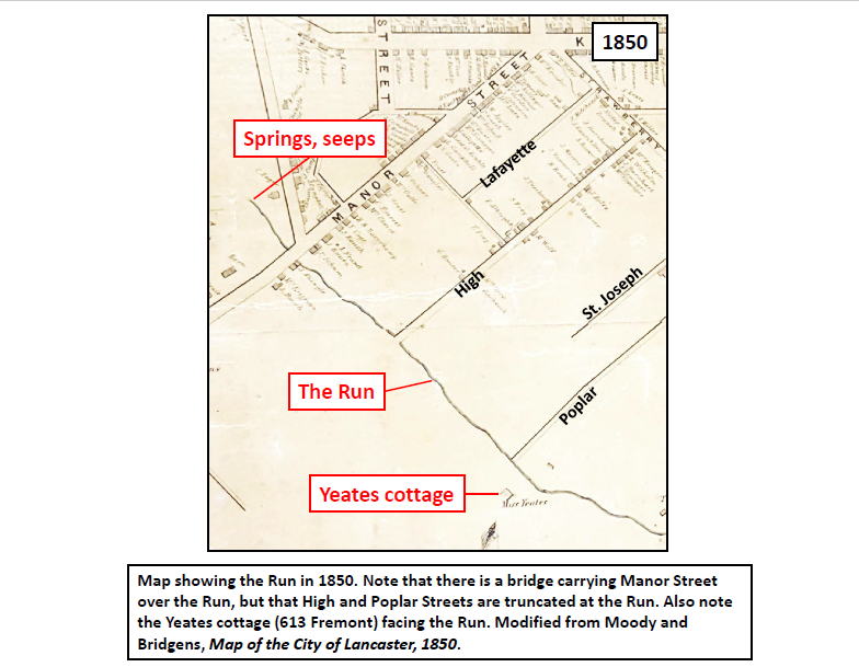
now, which was sometimes referred to as simply “the Run”.
The Run began at several springs and seeps northwest of
Manor between Dorwart and Caroline. From there, it flowed southeast a little
more than a half mile before it reached the larger stream on South Water. The
area of the Run’s watershed was about 250 acres, covering most of Cabbage Hill.
The bedrock beneath the Run was limestone, like under the rest of the city, and
the stream banks were lined with trees and wetland vegetation.
Comparing the Run to same-sized streams in similar settings in
Lancaster County today, it is possible to estimate its flow characteristics. The
Run was likely only a few feet wide and less than a foot deep most of the time,
but probably reached more than twenty feet wide and several feet deep during
heavy rains. Between storms, the flow rate was probably only a couple hundred gallons
per minute, but during storms, the rate would have reached several thousand gallons
per minute, enough to flood adjoining streets and basements. High flows would
have made it difficult to cross the Run by foot, horse, or wagon, without a
bridge.
In the early days of development on the Hill, the building
lots containing or adjacent to the Run were among the most desirable lots to
own. The Run provided not only water for drinking, cooking, washing, and
conducting business, but also a conduit for carrying away the wastes generated
by residents and businesses. The first house built in the central part of the
Hill—Catharine Yeates’ summer home, known as Green Cottage, now 613 Fremont—was
built fronting the floodplain of the Run, taking advantage of the benefits of
being located near flowing water (see 1850 map). However, when Lancaster’s
public water supply became available in the mid-1800s, the problems of
flooding, insects, rodents, odors, and pollution associated with the Run soon outweighed
the benefits.
In 1878, the city developed a plan for the addition and extension of numerous streets. On the Hill, the plan included many street improvements, including the opening of Fremont and Union and the extension or widening of Filbert, Laurel, Hazel, and Wabank. The plan also included the opening of a new street, soon to be called New Dorwart, which was to be built from Manor to Union, where the Run and its floodplain were located. In 1880, a trench was started down the middle of the street to contain the stream. In 1883, the construction of a six-foot-high brick sewer was started in the trench. By the late 1880s, the sewer had been completed from Manor to Poplar, the new street had been built over it, and new houses had begun to spring up on both sides. By the early 1890s, the sewer had been completed all the way to Union. The Run had disappeared from view, a casualty of development.
But, before it was diverted underground, the Run had a major
impact on the establishment of the streets on the Hill. Manor Street, which had
existed in the early 1700s as the road to Blue Rock on the Susquehanna River,
had long required a bridge over the Run (see 1850 map). High Street, on the
other hand, did not extend beyond the Run in 1850, being truncated by the
difficulty of crossing the Run during high flows. The newly constructed Poplar
Street also was truncated by the Run in 1850.
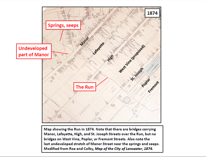
As the Hill developed rapidly from the late 1860s to the mid
1870s, additional streets were extended to the Run and required bridges. By
1874, in addition to a bridge having been built to carry High over the Run, Lafayette
and St. Joseph had bridges over the Run as well (see 1874 map). But the recently
proposed West Vine and the fledgling Poplar and Fremont did not have bridges.
Instead, they had to be forded when the flow was low enough to safely do so.
Prior to being buried in a sewer, the Run also affected the
geometry of the design for New Dorwart.
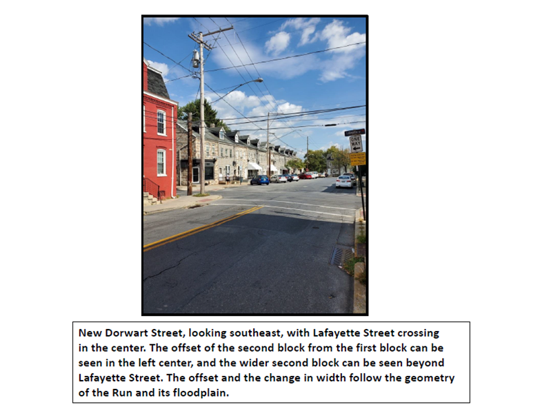
Due to the slightly northeast-bending shape of the Run east of Manor, and
the resulting widening of the floodplain northeastward, New Dorwart was offset
from the first to the second block, and again from the second to third block.
The resulting stair-step pattern along the northeast edge of the first two blocks
of the street remains today. Also, the wider floodplain where the Run curved to
the northeast is probably the reason that New Dorwart between Lafayette and
High is about twenty feet wider than elsewhere.
Another way that the Run affected early development was that
the northwest side of Manor between Caroline and Dorwart was the last stretch
of Manor to be developed (see 1874 map). The wetlands associated with the springs
and seeps at the head of the Run made that area perpetually wet and difficult
to build on. Even as late as 1897, almost two decades after the Run had been
diverted underground, this stretch of Manor was still not heavily developed due
to wet ground.
The Run that once ran through Cabbage Hill last saw the
light of day almost 140 years ago. But it clearly had a significant impact on
the development of the Hill, an impact that can still be seen if one takes the
time to look for it on historical maps and in today’s arrangements of streets
and houses. And, although its time on the land surface has long since passed,
the Run still trickles along in the large brick sewer beneath New Dorwart, albeit
a mere subterranean shadow of its former self. Now…”a river runs under it”.
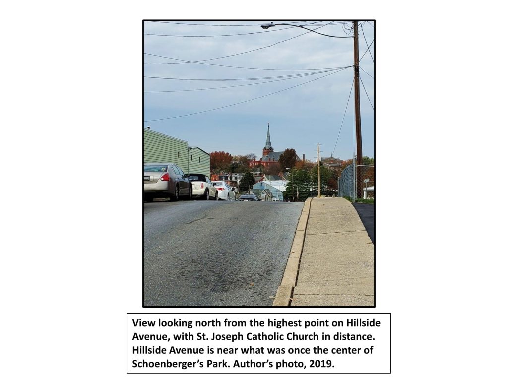
Dinah McIntire died 200 years ago in Lancaster, in May 1819,
at the reported age of 113. She was well known around Lancaster in the early
years of the nineteenth century as the fortuneteller who worked at the White
Swan Tavern in the square. Her death warranted a rare obituary in the Lancaster Journal, something usually
reserved only for prominent male citizens, as well as a note in Reverend Joseph
Clarkson’s journal about her burial in the St. James Episcopal Church cemetery,
despite the fact that he was in Philadelphia at the time.
Dinah was one of the few women of her time who owned
property; she had a small house near the intersection of West Strawberry and
West Vine Streets. The site of her house was said to be near the highest point
in that part of Lancaster, at the angle between West Strawberry and West Vine, and
her notoriety was such that the hill on which she lived became known as Dinah’s
Hill (see photo). By all accounts, she lived a remarkable life—all the more
remarkable because she was African American and a slave for most of her life,
including here in Lancaster.
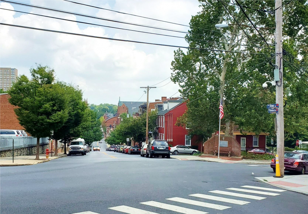
Photograph of the intersection of West Strawberry and West Vine Streets, looking east down the hill on West Vine. Dinah McIntire lived in a small frame house at this intersection, which is near the highest point in this part of Cabbage Hill, which was called “Dinah’s Hill” throughout most of the 1800s.
According to several sources, Dinah McIntire was born into slavery
in the town of Princess Anne, Somerset County, Maryland, about 1706. She spent
the first half of her long life in Maryland, and raised four children there. She
was already in her fifties when Matthias Slough, a prominent early citizen of
Lancaster, bought her and brought her north to work at his White Swan Tavern.
When Dinah died in 1819, she owned two, and possibly three,
lots of land on the northeast edge of Cabbage Hill. She owned two of the lots
as early as 1798, when the lots were taxed as part of the 1798 federal Direct
Tax. The tax was based on the amount of land owned and the number of windows
and the total number of panes in the windows. One of Dinah’s lots was 62 x 242
feet and contained an 18 x 22 foot house and a 15 x 20 foot stable. The house
was a one-story log and brick house with two windows of six panes each, and the
stable was made of logs. The other lot she owned in 1798 was larger and
apparently not built on; it measured 137 x 191 feet, adjoining the first lot.
In 1816, three years before her death, Dinah McIntire,
having long outlived her four children, prepared a will in which she left all
of her property and belongings to Jacob Getz, a young Lancaster silversmith. Like
Dinah, Getz attended St. James Church in 1815, when he and his wife Martha had
their first child baptized there. By 1816, when Dinah wrote her will, Getz had apparently
befriended her to such an extent that she named him as her executor and sole
heir.
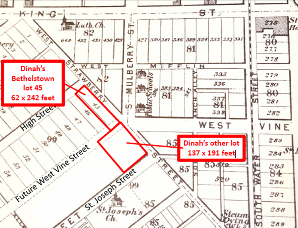
Map showing the two lots that Dinah McIntire owned from at least 1798 to 1819 when she died. The lots are near the intersection of West Strawberry and West Vine, where Dinah is supposed to have lived. (The map is from 1875, so the features shown are not the same as they were when Dinah was living there. The map is modified from Everts & Stewart, Lancaster County Atlas, 1875.)
When Dinah died in 1819, Getz became the owner of Dinah’s
property. Ground-rent records for Bethelstown, laid out by Samuel Bethel, Jr.,
in 1762, show that Jacob Getz became the owner of Bethelstown lot 45 after
Dinah’s death. Lot 45 was 62 feet wide and 242 feet deep, and was bounded on
its long dimension by West Strawberry between High and West Vine. This was
clearly one of the two lots left to Getz by Dinah McIntire, and an examination
of deeds shows that the other lot, which was a little larger, was immediately
adjacent to the southeast across what is now the extension of West Vine southwest
of West Strawberry (see map).
However, there is still some uncertainty surrounding exactly
where Dinah McIntire actually lived. One obvious possibility is the 18 x 22 log
and brick house on Bethelstown lot 45. But the most likely place for a house to
have been built on that lot was on the High Street end of the lot. At the time
Bethelstown was laid out, the other end of the lot did not front a street (the
extension of West Vine Street didn’t occur until much later). And if Dinah had
lived on the High Street end of lot 45, she would not have been at the angle of
West Strawberry and West Vine, and she would not have had a direct view down
the hill on West Vine, as numerous writers have claimed for her.
An article in The News
Journal of Lancaster on June 9, 1898, provides an alternative, and I think
more likely, location where Dinah may have lived. The article discusses how
“another old landmark of the city” was about to be removed. The landmark had
been condemned because it was too close
to the street and had become an eyesore. That landmark was a small frame cabin
on the corner of West Vine and West Strawberry, and the article states that it
was reputed to have been the house where Dinah had lived almost a century
before.
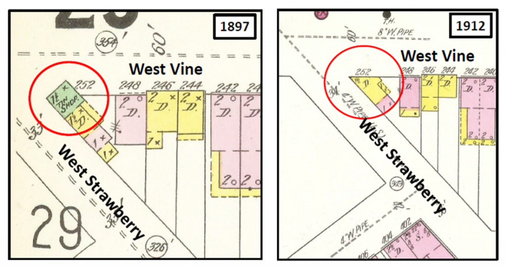
An examination of an old fire-insurance map of the city from
1897 shows that a small one-and-a-half-story frame house, then being used as a
tin shop, did indeed stick out into the street at the angle where West
Strawberry and West Vine meet. A 1912 fire-insurance map shows that the small
frame house was no longer there, which is consistent with the claim of the newspaper
article that the house was about to be removed in 1898 (see side-by-side maps).
I believe it is likely that this small house is where Dinah McIntire lived, and
that this small piece of land was the third lot that some writers have
attributed to her. The exact site of Dinah’s little house was where the
flagpole is today in front of the memorial to fallen soldiers.
Dinah McIntire probably lived in the small house shown in the 1897 map as a tin shop (green) jutting out into the street. An 1898 newspaper article stated that Dinah’s old house was about to be removed. The 1912 map shows that Dinah’s old house was removed as planned. Maps modified from Sanborn Insurance Maps of 1897 and 1912.
Now, to complete the story of Dinah McIntire, we are
compelled to circle back to the potentially problematic life of Matthias
Slough, Dinah’s Lancaster slave master. Slough was as prominent a citizen as there
was in Lancaster in the late 1700s. During the Revolutionary War, he served as
the Colonel of the Seventh Battalion of the Pennsylvania Militia, and saw
action at the Battle of Long Island. He also served at various times as assistant
burgess, county coroner, county treasurer, and member of the Pennsylvania
Provincial Assembly and General Assembly, all while he was running the very popular
White Swan Tavern.
Certainly, this is a fine list of accomplishments worthy of
our respect. However, just like numerous other prominent Lancaster citizens in
the eighteenth century, Slough’s legacy is compromised by the fact that he was
a slave owner. From 1770 to 1800, Slough owned at least three to four slaves at
a time. In fact, a registry of Lancaster slaves indicates he owned eleven
slaves in 1780.
Curiously, Dinah McIntire is not one of the eleven listed
slaves in 1780. Did Slough free her before 1780? We know she was freed at least
by 1798, because she owned property then. It is possible she was freed before 1780,
because it was common for slave owners to free slaves when they reached old age
and Dinah was already in her seventies in 1780. Whether he freed Dinah before
1780 or closer to 1798, it is reasonable to think that the wealthy Slough may
have rewarded her for her years of servitude, and that her ownership of land
may have been a result of that reward.
Whether we should temper our respect for Matthias Slough
because he was so thoroughly invested in the “peculiar institution” of slavery
is a question for individual conscience and professional historians. It seems fitting,
though, that Dinah McIntire outlived her former slave master Slough, and that
her newspaper obituary was almost as long as his obituary. On top of that, Dinah
was the only one of the two for whom a hill was named.
The greatest expression of civic pride ever to take place on
Cabbage Hill in the Eighth Ward of Lancaster occurred on June 15-16, 1923. On
the evenings of those two days, a huge festival drew close to 10,000 people to
Manor Street to celebrate the long-awaited completion of the paving of the
street. More than $6,000 (about $84,000 in today’s dollars) was raised to
benefit Rodney Park, a new city park on a triangle of land between Third,
Rodney, and Crystal Streets.
The surface of Manor Street had been in terrible condition
for many years. Finally, in early August 1922, work crews began the process of
excavating the street so it could be paved with concrete. The city’s
contractor, Swanger-Fackler Construction Company of Lebanon, was responsible
for the overall project and the paving of most of the street, and Conestoga
Traction Company was responsible for moving the trolley tracks from the edge of
the street to the middle, and paving the street around the trolley tracks. The
work proceeded slowly, as the crews ran into several unexpected complications
as they excavated 150 years’ worth of old street surfaces.
When cold weather set in during the late fall and concrete
could no longer be poured, work was halted for the winter, leaving some
sections of the street torn up and virtually impassable. Fortunately, by the
first week of April in the spring of 1923, the weather was good enough for the crews
to get back to work. Progress was steady throughout April and May, and by late
May the residents of the Eighth Ward were hopeful that the work would finally
be completed by mid-June.
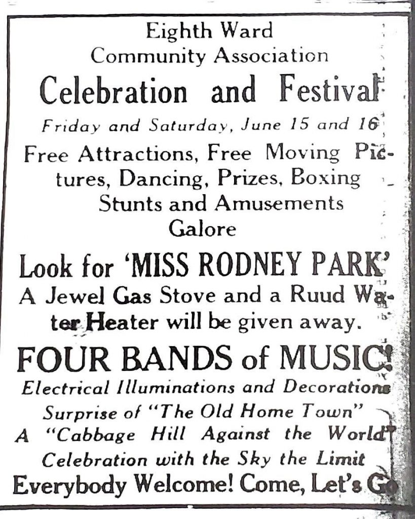
The Eighth Ward Community Association met on May 25, May 31,
and June 7 to develop plans for a festival to celebrate the opening of the
newly paved Manor Street. The festival was scheduled for June 15-16, 1923, and
the Association decided to dedicate the proceeds of the festival to outfitting
Rodney Park—acquired by the city just two months earlier—with playground
equipment and a surrounding sidewalk for roller-skating.
Advertisement for festival in Examiner & New Era, June 15, 1923
In late May, the Association canvassed door to door in the
Eighth Ward to gauge the level of interest and ask for donations to support the
festival. The canvassing generated much enthusiasm and many donations; in fact,
the level of interest was so high that the Association decided to expand the
scope of the event from just a Manor Street opening to “A Cabbage Hill Celebration and Festival”. One
of the leaders of the Association said that “this is the first time in the
history of the city that such a celebration has been held” and that “it is for
all the people”.
To plan the festival, twenty-six committees were established,
with each committee having a chairman and three to five other men as members. The
women had their own committees, most of which corresponded in topic with the
men’s committees, and the two sets of committees worked together to prepare for
the festival. Committee chairs were selected for their expertise in the area of
the committee’s topic. For example, Christ Kunzler of Kunzler’s Meat Market was
the chair of the Hot Frankfurter committee, and Leo Houck of boxing fame was
the chair of the Sports committee.
The committees included: Program, Publicity, Music,
Decorations, Amusement, Sports, Dancing, Candy, Prizes, Hot Frankfurters, Soft
Drinks, Popcorn, Flowers, Ice Cream, Fruit, Truck, Ice, Printing, Cigars,
Equipment, Lumber/Chairs/Tables, Public safety, Tags, Cakes, Novelties, and Fancy
Work. Probably to many people’s chagrin, there was no Beer committee—at least
not officially—because the 18th Amendment (Prohibition) had gone
into effect a few years earlier.
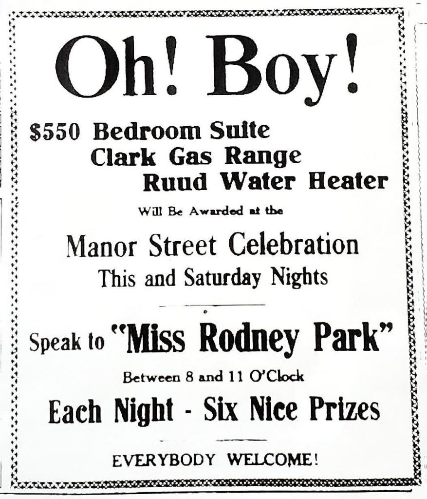
Advertisement for festival in Intelligence Journal, June 15, 1923
In the days leading up to the festival, several items were
donated to be used as prizes. Congressman William Griest donated a new Ruud water
heater that was put on display in the window of Louis Fellman’s hardware store
(568 Manor Street) to help ratchet up interest. The Conestoga Traction Company donated
a new Clark Jewel gas range, which was also displayed at Fellman’s store. The Friends
of the Eighth Ward Community Association donated a $550 mahogany bedroom suite
that was displayed at Hoffmeier’s furniture store on East King Street near the
square.
Cash donations also were made. Christ Kunzler took up a
collection of $87 at an Elks Club dinner held the week before the festival, and
he also paid for the first hour of music by a band at the festival. Hamilton
Watch Factory and Armstrong Linoleum Company each gave $50, as did the
Fraim-Slaymaker Lock Company. The Select Council also presented a cash
donation. In addition, the Intelligencer Journal and the Examiner-New Era newspapers
would supply Rodney Park with a drinking fountain and a flagpole.
To the relief of all the committees, the paving of Manor
Street was completed on time, and by the afternoon of Friday, June 15, the
final preparations for the festival were underway. Two large banners were
strung across the street at the ends of Manor Street—one at the crest of the
hill near West King Street and one near South West End Avenue. American flags
and bunting were displayed along the street and on many of the houses (Flag Day
was the previous day), and colored electric lights were strung along and across
Manor Street from West King Street to Fairview Avenue. Dozens of booths that
had been built by the residents and decorated with flowers lined the street on
both sides.
It was partly cloudy and about 80 degrees when the festival
kicked off at 6:30 p.m. Friday evening. At that time, the leaders of the Eighth
Ward Community Association, the American Legion Band, and some 500 school
children of the Eighth Ward departed in a parade from the intersection of Manor
and Dorwart Streets. They marched to City Hall, where they met Mayor Frank
Musser and other city officials and escorted them back in the parade to the
intersection of Manor and West King Streets, where a fence barrier had been
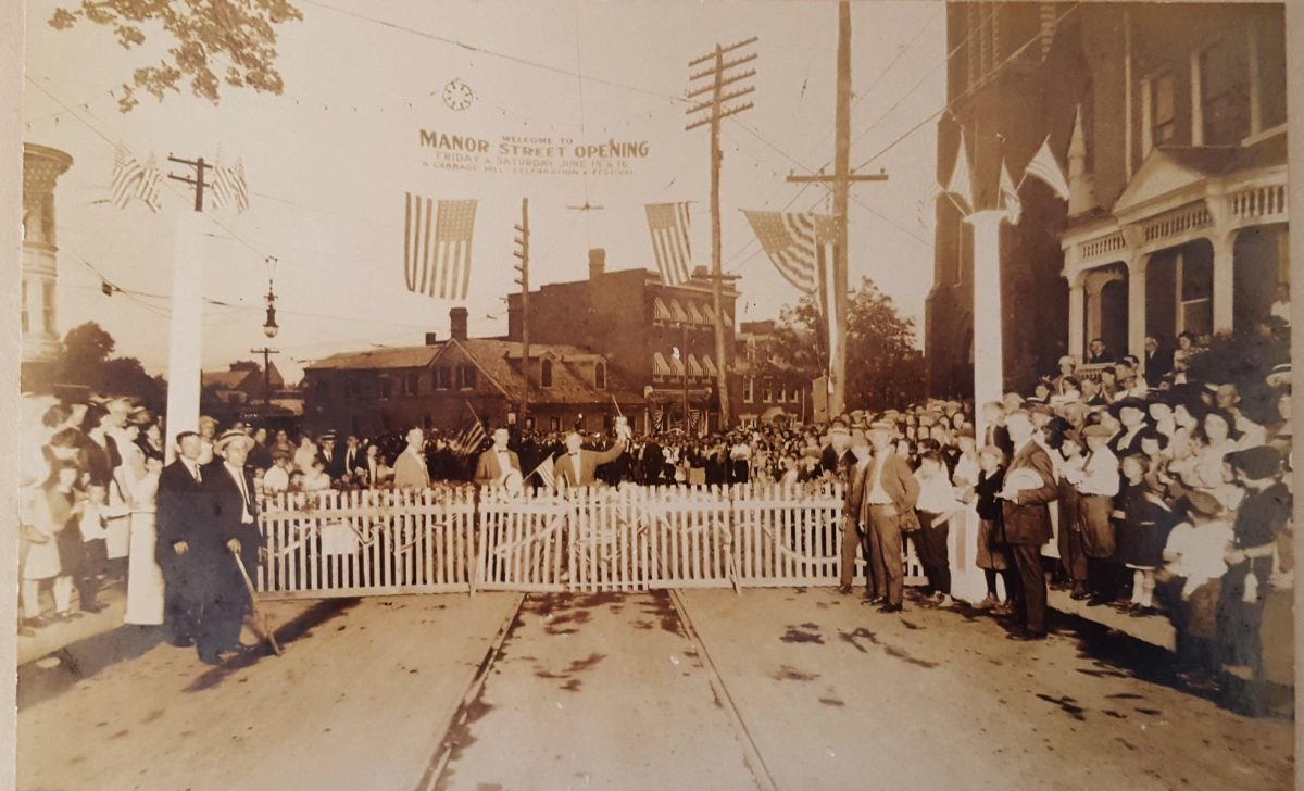
erected across Manor Street.
At the barrier, the mayor was presented with a new axe, and
with one stroke he broke through the ceremonial barrier, officially opening the
newly paved street. Immediately after
the barrier was broken, a chorus of children sang a welcoming song, and a
switch was flipped, lighting all the colored electric lights along the street.
The Star Spangled Banner was played, followed by a short speech by the mayor.
At the end of the ceremony, the whole group of officials, school children, and
the American Legion Band paraded the length of Manor Street to great cheering.
The festival was officially underway.
Photo of the ceremonial breaking of a barrier to open the newly paver Manor Street on June 15, 1923. The barrier is in front of 412-414 Manor St. Mayor Frank Musser stands in front of the barrier to the left. The banner reads, “Welcome to the Manor Street Opening, Friday & Saturday, June 15 & 16, A Cabbage Hill Celebration and Festival”.
For the festival, Manor Street was divided into three segments,
each with a distinct focus—dancing, boxing, and amusements. Four bands,
including the American Legion Band, the Iroquois Band, and the City Band, participated
over the two nights, and each one was stationed at a different segment. The
segments were linked together by the strings of colored lights that extended
along the entire stretch of the street, and by 33 booths that lined the streets
between the segments, offering the Eighth Ward’s best food, drinks, clothing,
novelties, and hand-made items for sale.
The block of Manor Street between Laurel Street and Fairview
Avenue was set aside for street dancing, with the music supplied by the
American Legion Band. Rousing Roaring Twenties music was no doubt on the
program, and the young people of the Eighth Ward danced until the festival
closed each night. At one point during the dancing, the lights briefly went
out, and the newspaper slyly reported that this unexpected feature was much
appreciated by the young revelers.
The intersection of Manor and Dorwart Streets was designated
for exhibition boxing matches, and a ring was set up in the street. Each night,
there were five, three-round exhibition matches arranged by Leo Houck, the
Eighth Ward’s own boxing hero. One match was for the championship of the
Fraim-Slaymaker Lock Company (Young Biddy vs. Willie Bloom) and another was for
the 125-pound title of Manor Street (Battling Fuzzy vs. Kid Carney). The final,
much anticipated match was Leo Houck, who had fought many of the world’s best
boxers in the previous two decades, facing off against his long-time sparring
partner, Jule Ritchie. Unfortunately, Ritchie was late and the feature bout had
to be replaced with a quickly arranged one between two different boxers.
The intersection of Manor and Third Streets was set up for
amusements. Eddie Fisher, a well-known local clown, was in charge of the
program at this location. Each night, the YMCA provided a gymnastics and stunts
exhibition, and Fisher and a troupe of clowns performed. A little farther down
the hill, the Strand Theater in the 600 block of Manor Street provided a free
showing of a silent movie, and Brinkman’s Metropolitan Four sang a selection of
songs. On Saturday night the Strand hosted a public wedding of a couple from
Columbia, officiated by a pastor from Marietta.
An unusual feature of the festival that must have served as
a good ice breaker was the Miss Rodney Park contest. Each evening, in three
different hour-long time slots, a secretly selected young woman was designated
as Miss Rodney Park for that hour. She went out among the crowd incognito and
the first person who approached her with “You are Miss Rodney Park”, would be
the prize winner for that hour. No doubt many young women were approached by
many young men, but Miss Rodney Park was only correctly identified three times.
By the time midnight rolled around on Saturday night and the
festival was over, it was clear to everyone that it had been a much bigger
success than anyone had imagined. The crowds had been huge (almost 10,000 over
two nights), the booths were almost completely sold out of their merchandise,
and every featured event on the program had been a big hit. Over the next
couple of days, as cleanup took place, the Eighth Ward Community Association
counted up the proceeds and decided on the distribution of prizes, which were then
awarded on Tuesday night, June 19, at Fellman’s hardware store. The amount of
money raised exceeded $6,000, and on the night of June 20, again at Fellman’s
store, the Community Association met with the City Parks Committee to discuss
how to best use the money for Rodney Park.
The Eighth Ward had done itself proud. For two nights, the
residents had channeled their abundant civic pride into accomplishing the
largest festival ever seen on Cabbage Hill. The people of other parts of
Lancaster who had joined in the festivities left with “a lot of respect for the
manner in which the Eighth Ward does things”, as one of the newspaper articles
put it. It was hoped that the paving of the street and the successful festival
might end the long held opinion that Cabbage Hill was not treated like a fully
accepted part of the city. In fact, one of the newspaper articles stated that
the reconstruction of the street was “the first thing worth while the Hill has
ever gotten from a city administration”. At least for two nights, on June 15-16,
1923, Cabbage Hill had finally gotten its due.
The City of Lancaster and SoWe are committed to promoting the
same kind of neighborhood pride that made the 1923 celebration such a success.
The city has installed pedestrian-style streetlights along Manor Street and
part of West King Street, and has started the process of planting trees along
the street as well. And SoWe, with its many partners, is working on numerous
initiatives to build neighborhood pride, including a cost-sharing program to
improve building façades on Manor Street, especially those that once had
storefronts. It is hoped that all these efforts will help rekindle some of the
proud neighborhood spirit of the past.
In 1919, things were generally looking up in the U.S.—World
War I had just ended, unemployment was nearly negligible, and women finally
were getting the right to vote. On the other hand, the Spanish flu pandemic
made a comeback, and the Ku Klux Klan continued to stoke fear in many states. And,
for better or worse, depending on your point of view, the 18th
Amendment (Prohibition) went into effect. In the midst of these national
events, Cabbage Hill was beginning to recover from the anti-German sentiment
brought on by the war. As part of that recovery, the Hill was definitely “open
for business”.
Ever since its first neighborhood was established in 1762 on
Manor and High Streets, Cabbage Hill has been home to enterprising residents
who have operated their own local businesses. In the late 18th and
early 19th centuries, these businesses provided necessary subsistence
services that reflected the trade skills of its mostly German immigrants.
Blacksmith, shoemaker, carpenter, and butcher shops were common local
businesses.
During the late 19thcentury, Cabbage Hill
businesses continued to evolve with the times, and businesses such as bakeries,
barber shops, tailor shops, cigar factories, and grocery stores were common. A community
of immigrants that often felt somewhat separate from the main part of
Lancaster, the Hill seemed to have at least one of every type of business,
allowing it to get along without depending too much on the rest of the city.
In the early years of the 20th century, continuing
technological change led to another gradual shift in the types of businesses on
the Hill, but the businesses still offered nearly every possible desired service
no more than a couple blocks away. The businesses continued to provide what the
residents needed and wanted, but they also embraced new technologies. For
example, one might find a car repair shop around the corner from a blacksmith
shop, or a new movie theater on the same block as an old beer saloon.
The year 1919 was typical of this evolving business
environment on the Hill, as the following paragraphs will show. But first, let
me define what I mean by “the Hill”. For this discussion, I focused on what
many consider the historic core of Cabbage Hill, that is, the area bounded by
Manor on the northwest, West Strawberry on the northeast, Fremont on the southeast,
and Laurel on the southwest. Defined this way, the Hill contains seven main
streets running northeast-southwest, and four main streets crossing those seven
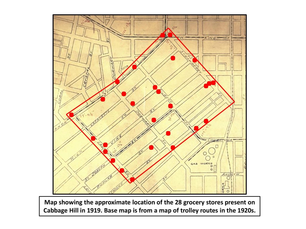
in a northwest-southeast direction, resulting in 21 blocks and 28
intersections.
The 1919 directory for Lancaster City advertised 125
businesses in the 21 blocks of the Hill. They ranged from the small scale (a
nurse operating from her house) to the large scale (Follmer-Clogg Silk Mill). Most
of the businesses (32) were on Manor, but High, West Vine, St. Joseph, and
Poplar each had about 15 businesses. Fifty-eight of the 125 businesses were
located on a corner of one of the 28 intersections. Nearly every business was
owner-operated, and nearly every business owner lived in or next to his/her
place of business.
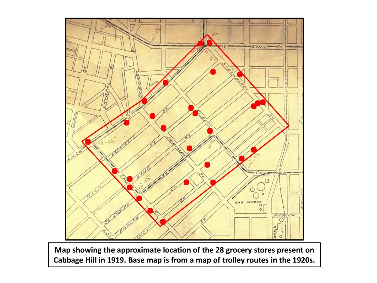
All the major types of businesses were found in multiple
locations on the Hill. Amazingly, there were 28 grocery stores (see map), more
than one per block on average. The Hill also had six hotels, six meat markets,
five bakeries, five shoemaker shops, five tailor shops, five dressmaker shops,
and five barber shops. Additionally, there were seven contractors and eight
nurses offering their services on the Hill.
As a sign of the changing times, there was a car repair shop
(Crawford Garage, on New Dorwart) and a movie theater that showed early silent
moving pictures (The Manor, on Manor). Twenty-five other types of
businesses—ranging from a jewelry shop to plumber shops to cigar stores to
saloons—were represented at least at one, and at as many as four, locations. No
doubt the owners of the two saloons (Joseph Fritsch’s, on High, and Charles
Kirchner’s, on Poplar) were wondering how the new Prohibition law might affect
them.
Also of interest are the types of businesses that were absent
from the Hill in 1919. Despite there being 70 physicians in Lancaster, there
was only one doctor’s office (Lewis Shear, on Manor). There were 86 lawyers in
Lancaster, but no lawyer’s offices were located on the Hill. There were no banks,
insurance-agent’s offices, dentist’s offices, real-estate offices, optician’s
offices, photography studios, or restaurants. Clearly, Cabbage Hill was very
much a working-class neighborhood. The businesses on the Hill served the basic,
day-to-day needs of its residents, who had to go into Lancaster proper on
occasion to avail themselves of the professional services found there.
The plethora of businesses on the Hill, and the fact that
business owners were also residents, helped make the Hill a dynamic and
pleasant place to live in 1919. Starting in the second half of the 20th
century, for a variety of reasons, the number of businesses on the Hill declined
dramatically. Today, there are only six groceries, and only about a dozen other
businesses with advertising signage, and most of the businesses on the Hill
today are no longer owned and operated by Hill residents or located in their
houses.
SoWe hopes to reverse that trend. One of SoWe’s goals is to
improve support for southwest Lancaster’s entrepreneurs and small business
owners, which among other approaches involves revitalizing abandoned business
locations and opening up old storefronts. If SoWe is successful, perhaps the
Hill can recapture some of the favorable business environment that allowed the
neighborhood to be so “open for business” 100 years ago.
If you know of a historic Cabbage Hill business that may
have an interesting history, and think that its history might make a good topic
for a future post on this blog, please contact me at SoWeCommunicate@sowelancaster.org,
and I will look into it.
For those of you who like the details…….here’s the list of
125 businesses on the Hill 100 years ago, alphabetically by street name:
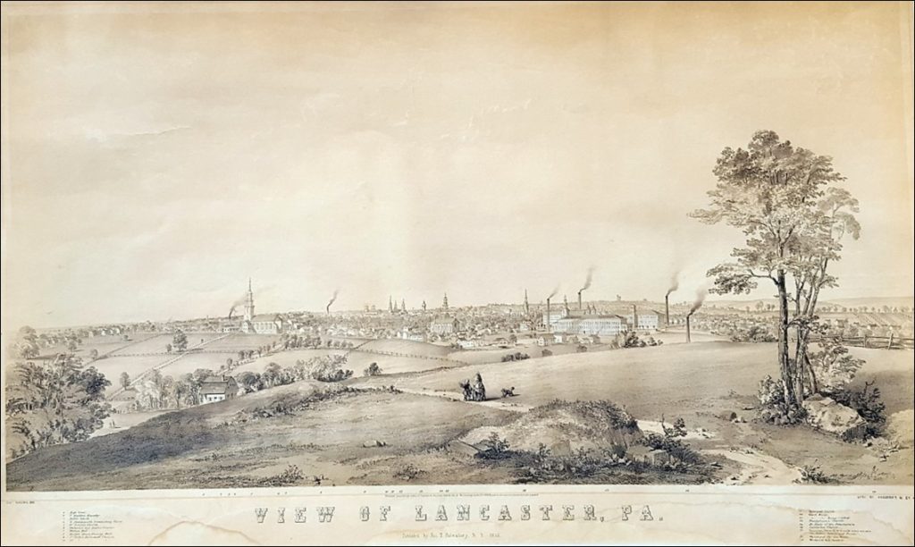
Sometimes an image inadvertently captures a scene just
before it changes forever, locking in all the little details that will never be
the same again. A lithograph of Lancaster as seen from the southwest in 1852 is
just such an image. It was drawn with such attention to detail that it is almost
as good as a photograph. But in one way, it is even better than a photograph
because a photographer in 1852 would not have had the specialized equipment to
take an almost 180-degree panoramic photograph.
The lithograph is entitled “View of Lancaster, Pa.” It was
drawn by Charles R. Parsons in 1852 and published by James T. Palmatary in
January 1853. Parsons was an English immigrant who apprenticed under George Endicott
in New York City, and “View of Lancaster, Pa.”, done when he was thirty-one, was
one of the first works of his long and distinguished career. Palmatary, also an
English immigrant, was a famous lithographer in the mid-nineteenth century, who
published many innovative lithographs of birds-eye views of major American
cities. Parsons and Palmatary executed their work well, as an article in the Lancaster Intelligencer of January 18,
1853, advertised their 18×34-inch product as being “drawn from nature” and
having a “rich and life-like appearance”.
“View of Lancaster, Pa.”, drawn by Charles R. Parsons in 1852 and published by James T. Palmatary in 1853.
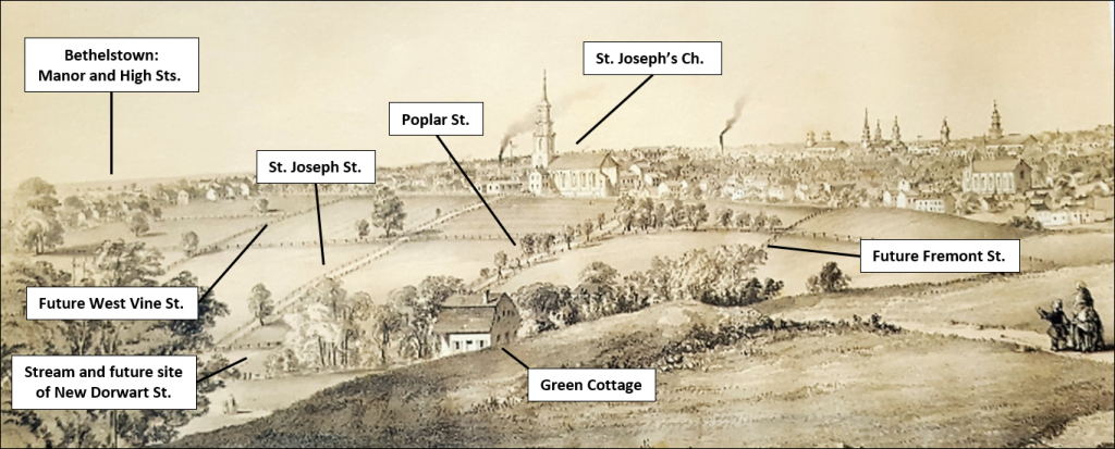
The “View” shown in the lithograph extends from Manor and
High Streets (Bethelstown) on the left (northwest) to Woodward Hill Cemetery on
the right (southeast). It shows Lancaster as it appeared in 1852 to an artist
sitting on a hill with an unobstructed view of the city. It quite faithfully
reproduces churches, schools, factories, public buildings, and other landmarks
of 1852 Lancaster with exacting precision. It includes some landmarks that had
only recently been added to the city’s skyline, such as Fulton Hall (1852),
Woodward Hill Cemetery (1852), Conestoga Steam Cotton Mills (1847), St.
Joseph’s Catholic Church (1849), and even the new County Courthouse (1852) shown
under construction in the scene.
But even more noteworthy for the history of Cabbage Hill is
what is captured in the foreground of the “View”—a nearly empty landscape that
had no inkling it was about to experience a virtual frenzy of development
leading to the densely built and populated neighborhood we see today. Open
pastures separated by fences and tree-lined farm lanes dominate the foreground
of the lithograph. There are only two buildings seen on the central part of what
would soon be called Cabbage Hill—St. Joseph’s Church in the left rear
foreground and a house in the left middle foreground.
The topography of the Hill, which is difficult to fully
grasp today amid all the houses, is clearly depicted. One can see that Cabbage
Hill is really two hills separated by a valley. The hill in the foreground
where Charles Parsons stood to draw the “View” is the southern hill and the
hill where St. Joseph’s Church stands is the northern hill. The valley traversing
the scene from left to right is the valley in which a tributary of Hoffman’s
Run flowed on its way to a larger stream along South Water Street.
Several features that are important to the history of Cabbage
Hill are captured in the scene. On the far left, several rows of houses trail
away from the city toward the edge of the drawing. This is the only part of
today’s Cabbage Hill that was developed in 1852. It is the neighborhood of
Bethelstown along the first two blocks of High and Manor Streets that was laid
out by Samuel Bethel, Jr. in 1762, and that had just begun to finally take off
in the late 1840s. In the right center of the drawing are the three large
buildings of the Conestoga Steam Cotton Mills on South Prince Street. In the
late 1840s, these three mills and St. Joseph’s Church played key roles in
attracting the new residents that were about to lead to the explosive growth of
Cabbage Hill.
New streets and future streets can be identified on the
lithograph. St Joseph Street can be seen as not much more than a fence-lined farm lane emanating from the left side of St.
Joseph’s Church and heading down to the tributary stream in the valley, where
some thirty years later, New Dorwart Street would be constructed after the
stream was drained into a large sewer beneath the street. To the right of St.
Joseph Street, another fence-lined and tree-lined lane—Poplar Street—follows the
same slope down to the valley bottom (are the trees lining this lane by any chance
poplar trees?). Less well defined to the left of St. Joseph Street is another
parallel fence line that looks like it might be the future site of West Vine
Street. A similar fence line to the right of Poplar Street could be the future
Fremont Street, as it seems to be leading to the house in the left foreground,
which stands on Fremont Street today.
Enlargement of the left side of “View of Lancaster, Pa.”, showing important features of Cabbage Hill in 1852.
That house, partially hidden from Parsons’ view by the southern
hill, and nestled on the lower slope above the valley floor, was the summer
cottage of Catherine “Kitty” Yeates, daughter of Jasper Yeates, prominent lawyer
and judge of late eighteenth and early nineteenth century Lancaster. The house,
known as Green Cottage, was built about 1820 as Miss Yeates’ summer cottage, and
was the first house other than small farmhouses in the central part of Cabbage
Hill. The artist even captured the slight change in angle of the gambrel roof
that can only be seen in today’s roof upon close inspection. The house was
later owned by Alexander J. Gerz and used as a hotel, and it still stands today
at 613 Fremont Street, adapted for use as apartments.
The buildings in the “View” are drawn with such accuracy
that one can use their positions relative to each other to locate the general
area where Charles R. Parsons positioned himself to make the drawing. The spot
where Parsons set up his easel was the hilltop near where Frank’s Garage is
located in the 600 block of Union Street. Only from that location does the
alignment of the Yeates cottage with St. Joseph’s Church match the alignment in
the “View”. And only there do the relationships among the buildings of the
Conestoga Steam Cotton Mills (now Water Street Rescue Mission , Carter & MacRae
Elementary School, and the office of the School District of Lancaster), agree
with the relationships in the lithograph
Fortunately, a high-quality original of this lithograph
survives in the Wheatland Collection at LancasterHistory. It currently hangs in
what appears to be its original frame in the rear stair hall at Wheatland. It
provides a rare glimpse of a moment in time, fortuitously captured more than
165 years ago, just before the central part of Cabbage Hill blossomed with
development.